

What is Wilderness?
Examining tree rings, researchers reconsider the history of human influence in the Boundary Waters.
by Evan Larson
Published with permission of the Minnesota Conservation Volunteer
Wilderness is a poignant word that conjures up images of sweeping tundra, rugged mountains, and primeval forests broken only by lakes and winding rivers. The common feature shared by these images is the absence of human influence. This perspective was codified in the 1964 federal Wilderness Act, which defined wilderness as land “untrammeled by man, where man himself is a visitor who does not remain.”
What would it mean if landscapes we now consider wilderness were, at least in part, the legacies of human activity?
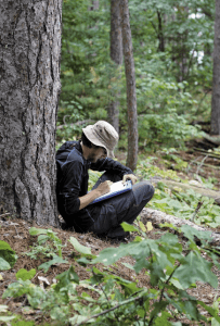
As an associate professor of geography at the University of Wisconsin–Platteville and a dendrochronologist, or tree-ring scientist, I am pursuing answers to such questions. Over the past five years, I have collaborated with professor Kurt Kipfmueller and research specialist Lane Johnson from the University of Minnesota, as well as students from both of our institutions, on research to seek a more complete and nuanced understanding of wilderness. Funded by the National Science Foundation, this research may help guide the management of the Boundary Waters Canoe Area Wilderness—an iconic Minnesota landscape—by considering the role of people in its history.
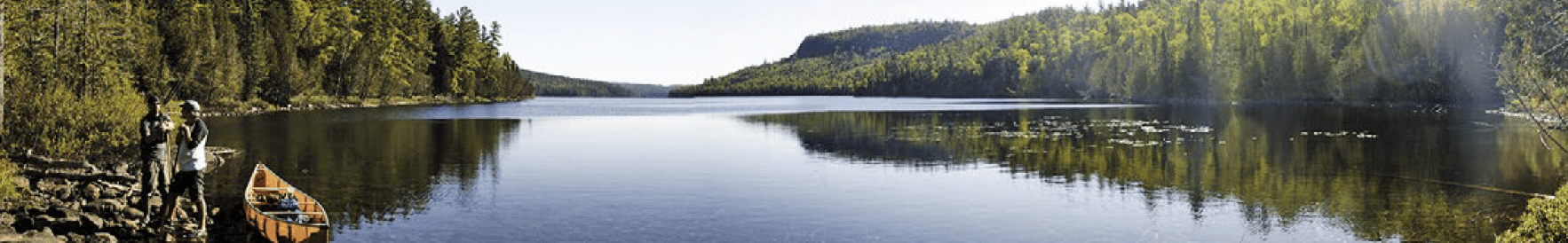
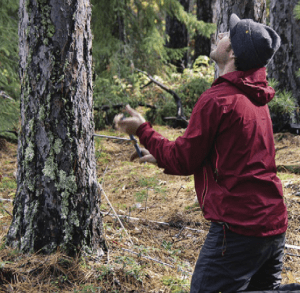
My own perspective on wilderness in the BWCAW was transformed on day four of a late August trip to Lac La Croix, a massive island-studded lake along the border of the United States and Canada. The winds had picked up and the water was growing choppy as my research crew and I neared a site that Johnson had urged me to visit. We paddled around a small point, spotted a landing, and pulled up our canoes in the shade of towering pines. The landing was directly along the Border Route, once a primary fur-trade corridor from Lake Superior to Rainy Lake.
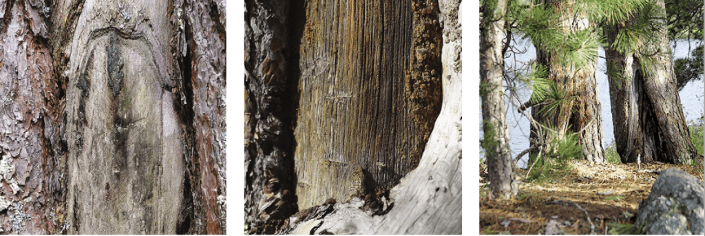
The trees at this site had stories to tell. Nearby, the trunk of a fire-scarred, wind-thrown red pine displayed a long, vertical wound. Upon closer inspection, marks from an ax were evident, but barely, as centuries of healing wood curled over the wound. The injury was intentional. At one time, this injury ran thick with resin. When combined with wood ash and animal fat, this resin created the gum used to seal the seams of birch-bark canoes. Scanning the forest, we noted that nearly every large red pine within sight bore a similar scar.
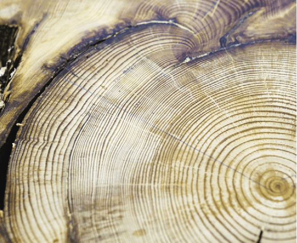
By examining annual growth rings in increment cores taken from tree trunks, we found that many pines at this site were more than 250 years old. Distinct injuries recorded within their rings denoted the passage of multiple low-severity surface fires that damaged but did not kill many of these trees. In all, 16 fires burned here between 1660 and 1909, after which fires abruptly ceased.
Lightning certainly caused wildfires in the area, but the abundance of past fires seems too great to have been the product of lightning alone. And if lightning had been the cause, why were so many fires limited to this one stand?
In pursuit of answers to these questions, our research group has studied tree rings at 75 sites across the BWCAW. From these studies, we’ve developed an environmental narrative that helps us explore the meaning of wilderness.
Forest Sanctuary.
Protected by the BWCA Wilderness Act of 1978, this million-plus-acre landscape harbors some of the last pine forests spared during the logging era. Since then, the BWCAW has become a vital natural laboratory for scientists to understand the dynamics of northern ecosystems. With more than 150,000 visitors each year, the area has also become an integral part of many Minnesotans’ cultural identity through outdoor adventures and the search for wilderness experience.
Clear waters and deep forests convey a sense of the primeval, yet this landscape has a rich human history that spans thousands of years. In the 1700s Ojibwe settled in the area following a westward migration over the preceding decades. After the arrival of early European explorers during the 1700s and early 1800s, the area became a hub of trade among the Ojibwe and French-Canadian voyageurs. The journals of explorers and voyageurs include numerous mentions of trade relationships and locations of Ojibwe settlements.
Oral traditions and ethnographic research tell of the Ojibwe people using fire to clear encampments and trails and to promote plants such as blueberries, a highly valued food that grows vigorously on recently burned land. The intensity of land use varied from place to place, depending on local conditions and proximity to travel routes, resources, and settlements, yet people were clearly a part of the landscape.
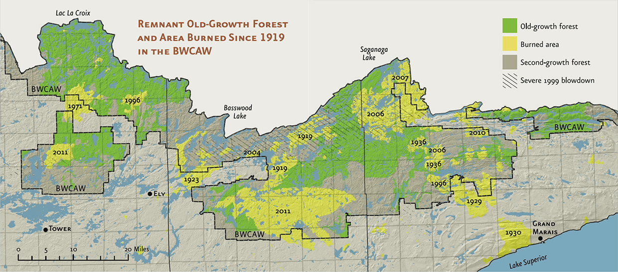
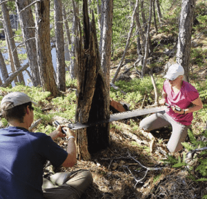
Working with historical documents and the advice of U.S. Department of Agriculture Forest Service archaeologists, our research team identified red pine stands on and off the historic Border Route. At each site we used tree rings to reconstruct historical patterns of fire.
Our work builds on the groundbreaking research of Miron “Bud” Heinselman, a preeminent scientist and strong advocate for the BWCAW until his death in 1993. As a U.S. Forest Service researcher during the 1960s and 1970s, Heinselman documented the role of fire in Boundary Waters forests. To do so, he used the ages of trees established after severe fires and fire scars recorded in the growth rings of living trees.
Heinselman’s research was fundamental to developing the field of fire ecology. He pioneered the concept of a “shifting forest mosaic” shaped by landscape-scale fires. Despite his remarkable efforts, questions remained. In a landmark 1973 publication, he wrote, “In the Boundary Waters, people were primarily an added source of ignitions until about 1910. … A relevant question, then, is how much burning would
have taken place prior to 1910 if only lightning ignitions had occurred? A direct answer is unobtainable.”
The rings of long-dead pines may now bring an answer within reach. Our research uses a technique known as crossdating, which provides us access to information hidden from Heinselman. Through previous research, we know that the amount of moisture available to red pine trees during the growing season influences the relative width of each annual growth ring. Wide rings correspond to wet summers, and narrow rings to dry ones. As weather and climate vary, uniform patterns emerge in the rings of trees across the region. Distinct as fingerprints, the patterns can be read to assign calendar dates to the rings of dead trees with absolute certainty. Through crossdating, we used fire scars in remnant stumps to produce a network of sites with fire history that spans the wilderness and tells a detailed story of fire activity over the last 400 years.
Cultural History.
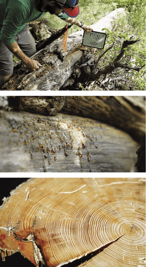
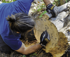
sample that still shows the resin Ojibwe people gathered
from such scars. Dendrochronology, the study of tree
rings, allows scientists to precisely date peel scar samples. Photos by Evan Larson.
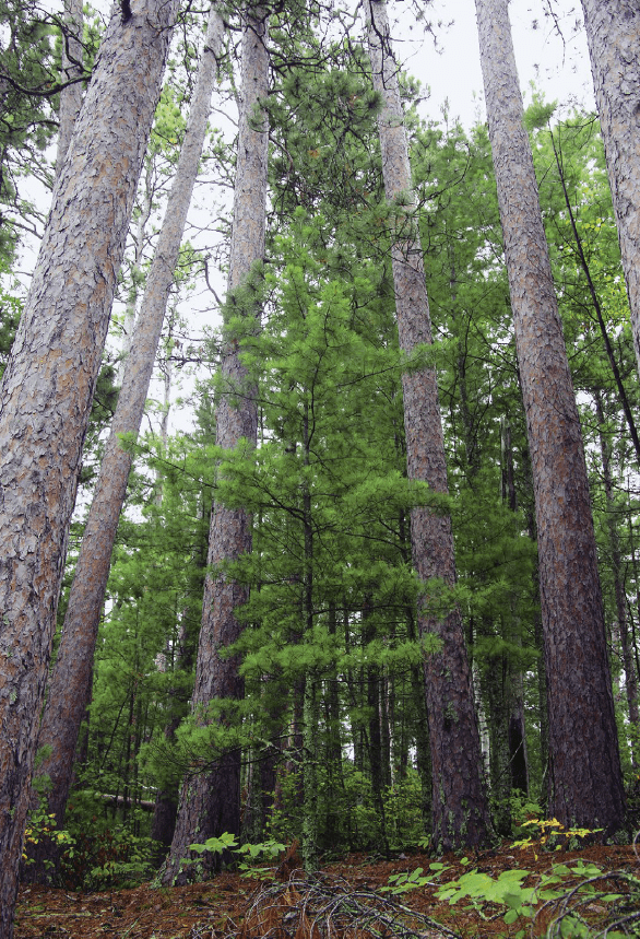
The fire patterns illustrated by our data are stark. Fires were most common along the Border Route. In some places, the open stands of red pine we see today experienced fires every five to six years during the 1700s and 1800s—the period when fur-trade networks were expanding across the region. Our data make a strong case that many of these spectacular red pine stands are, in part, legacies of the region’s cultural history.
In The Boundary Waters Wilderness Ecosystem, Heinselman stated that “old-growth red and white pine groves of the Boundary Waters reserves are among the most endangered forest communities of the entire Great Lakes region of the United States and Canada. They are an irreplaceable element in the biodiversity of the region.” Our data suggest that at least some of these pine stands took root and flourished in the presence of frequent surface fires, many
of which were likely set by people. By burning away tree seedlings and underbrush, these fires created the open, parklike forest structure prized by people in the past and today.
The more complete understanding of BWCAW forests emerging from our work poses challenging questions for managing the nation’s most visited wilderness area, particularly in an era of profound environmental changes.
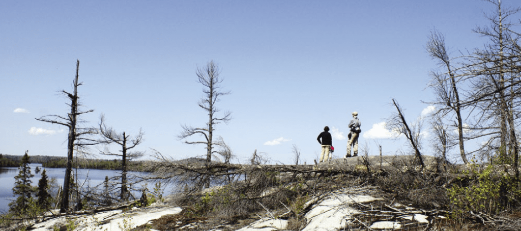
How then does the legal definition of wilderness square with stands of red pine that are quite possibly a product of historical land use? Should managers take a hands-off approach based on the idea of “untrammeled wilderness”—even while once-open pine stands grow denser and more susceptible to conflagrations? The severe effects of the recent fires such as Pagami Creek, Ham Lake, and Cavity Lake, which reduced many groves of old-growth pines to ashes and charred snags, illustrate the likely outcome.
Alternatively, do we identify heritage stands of ancient pines that represent the confluence of human and ecological processes and then actively manage them with prescribed fire? The aim would be to increase their resilience to the impacts of severe wildfires, provide opportunities for future regeneration of red pine, and maintain a vital component of the region’s ecological diversity.
These are difficult questions that require careful thought and reflection, but with the long absence of forest fires enabling a buildup of fuels, answers cannot wait long.
Wilderness Views.
In his essay “The Loons of Lac la Croix,” Sigurd Olson evoked a longing for the deep connections between people and wilderness through his lyrical descriptions of pictographs on granite cliffs and a hill challenged by Ojibwe runners.
Olson wrote about a pine stand along the Border Route “as perfect as any we had seen” where a trapper’s cabin had “seemed a part of that scene, its quiet serenity part of the tall, smooth trunks and the silences.” As researchers, we have been to this stand and documented peeled trees that tell of human land use in the 1790s and early 1800s. From the tree rings of charred stumps, we now know that fires passed through in 1739, 1757, 1764, 1867, 1875, 1892, and 1915. Fires stopped burning here as the traditional lifeways of the Ojibwe were constrained. The pines Olson refers to remain on the landscape today, though the forest around them is changing.
“ladders” that will allow fire to climb to the canopy. Photo by Evan Larson.
In the end, people decide the definition and designation of wilderness. Today, public land managers are charged with the difficult task of preserving the beauty, function, and biodiversity of wilderness areas in the face of changing climate conditions and increasing human use. A growing body of evidence suggests that active management that includes the use of prescribed fire can help maintain resilient forest communities. Wild places that were profoundly impacted by the actions of people in the past need not devalue the wilderness concept. Rather, this knowledge can make them richer through tangible connections to our human history.
The stands of ancient pines on Lac La Croix embody the ideal of wilderness, yet they have felt the tread of moccasins and boots on their roots for centuries. Recognizing the role of past human influences in creating these magnificent stands may help people learn how to be better stewards of wilderness today.
Contributors:
Evan Larson, Associate Professor, Department of Geography, University of Wisconsin-Platteville
Dr Kurt Kipfmueller, Associate Professor of Geography, Environment and Society at the University of Minnesota
Lane Johnson, Research Forester, Cloquet Forestry Center, University of Minnesota