

By Matthew Davis
The National Park Service and North Country Trail Association (NCTA) are trying to obtain passage of legislation in Congress that would enact the “Arrowhead Re-route”– a proposal to route the nation’s longest hiking trail through the BWCA Wilderness.
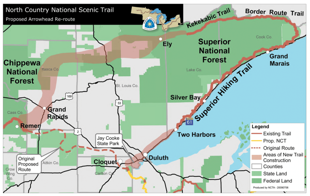
This legislation, when passed, would bring the 4,600-mile long North Country National Scenic Trail to the Arrowhead region of Minnesota by linking the Superior Hiking Trail with the existing Border Route and Kekekabic Trails which cross through the BWCA Wilderness. The NCTA’s Arrowhead Chapter will build new sections of trail from the western end of the Kekekabic Trail near Ely to the existing North Country Trail segment within the Chippewa National Forest near Remer.
Identified as the preferred alternative in the National Park Service 2004 Northeastern Minnesota Route and Environmental Assessment, the re-route is supported by many Minnesota outdoors entities including the Superior Hiking Trail Association, Border Route Trail Association, Kekekabic Trail Club, Parks & Trails Council of Minnesota, Minnesota Department of Natural Resources, Superior and Chippewa National Forests, as well as many local government units.
The Border Route Trail stretches 65 miles from Cook County Rd. 12 (the Gunflint Trail ) to Otter Lake Road north of Hovland. Started in the 1970’s, the trail was completely finished by volunteers of the Minnesota Rovers Outing Club in 1993. The trail includes 35 miles within the
BWCA Wilderness and closely follows the US-Canadian border. Generally located on top of the ridges, the trail affords great views. As the Border Route Trail: a Trail Guide and Map published by the Minnesota Rovers says…
“Towering cliffs. Pristine lakes. Waterfalls. The quavering call of the loon. Mud. These and more await you on the Border Route Trail. Its remoteness in the boreal forest lets you see an ungainly bull moose and realize it’s not ugly—but majestic. Lets you be as high as a raven often flies. Or lets you see the snoot of a black bear and not panic.”
The Kekekabic Trail is a 38-mile long wilderness hiking trail that runs from Snowbank Lake Road near Ely to the Gunflint Trail near Round Lake. Originating as a forest fire fighting access trail from the 1930’s, the trail received its name from its original destination, Kekekabic Lake, now located along the central part of the trail. Most of the eastern half was cleared in 1949 by Boy Scouts while the eastern 2.5 miles follow the remains of a wagon road of a failed 1880’s iron mine. After falling into a state of disrepair from the lack of use and maintenance, the Kekekabic Trail Club re-opened the trail in 1990 and has maintained it since, working in close partnership with the Superior National Forest. Here is how one of the 1949 Boy Scouts described the ‘Kek’ as quoted in the Kekekabic Trail Club’s Hiker’s BWCA Wilderness Companion: Kekekabic Trail Guide…
“The Kekekabic Trail is one of the toughest, meanest rabbit tracks in North America. The trail struggles its way through swamps, around cliffs, up the sides of bluffs, and across rocky ridges. It is choked with nightmarish patches of clinging brush. It is blocked with tangles of windfalls and standing timber… It is the kind of trail that would break the heart of a man who didn’t have what it takes to go into the wilderness and try and ‘smooth it.’”
Since 99% of the BWCAW’s use is by canoe campers, hiking either of these two trails offers a fantastic way to experience the wilderness “via the back door.” The opportunity is yours to get above the landscape and see its beauty from the raven’s perspective. Of course, hiking these two trails is not for everyone. Hikers should be experienced backpackers and need to be prepared to deal with the true wilderness conditions found there.
Both the Border Route Trail Association and Kekekabic Trail Club organize trail clearing trips each spring to remove blowdowns and cut brush and both organizations are always looking for more volunteers. The Order of the Arrow Wilderness Voyage program of the Boy Scout’s Ely Canoe Base, Superior National Forest, and Conservation Corps of Minnesota/Iowa also help out annually with trail maintenance.
More information on the North Country Trail and the Arrowhead Re-route can be found online at www.northcountrytrail.org while the NCTA-Arrowhead Chapter’s online home is at www.meetup.com/Arrowhead-NCT-hikers/. Specific information on the Border Route and Kekekabic Trails can be found at www.borderroutetrail.org and www.kek.org.
This article appeared in Wilderness News Summer 2010