

The USFS–Superior National Forest began prescribed burns on 3,600 acres across the forest in mid-September. The agency will continue burning through early winter in areas identified as high wildfire risk or near communities. These efforts support a healthy ecosystem while reducing wildfire danger. As a result, forest specialists surveyed and scheduled controlled burns for nearly 8,200 acres for the 2025 season. Maps and locations of current burns, as well as resources for residents and visitors, are included.
Burn season kicks off
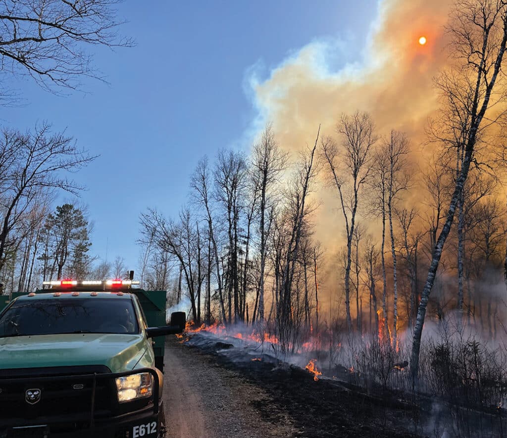
When fire danger is low in the Superior National Forest, Forest Service crews complete prescribed burns, typically in the spring and fall. The USFS-Superior National Forest (USFS) began prescribed burns for this year in mid-September. Crews usually carry out these prescribed burns in areas at high risk for wildfires or near communities. In some areas, crews will work for about a week and include 4 firefighters plus 2 contingency firefighters.
Indigenous people began using prescribed burning long before European contact, managing the land through natural cycles of fire. Lightning strikes also sparked wildfires across the landscape.“Fire is natural, and it needs to be part of the solution. Putting fire back on the landscape will rejuvenate areas needed for Indigenous people to exercise their treaty rights by creating better habitats to hunt and gather, and improve forest conditions. We have been burning in this area and across the nation for centuries, and we know it works,” said Damon Panek, Fond du Lac Wildfire Operations Specialist, in an interview with Boreal.org.
In the mid-20th century, the Forest Service implemented modern methods by scheduling prescribed burns in Minnesota. These burns mimic the natural wildfires that once swept through the region. They promote a healthy ecosystem by reducing overgrown vegetation and playing a key role in fuel reduction. Additionally, prescribed burns help restore wildlife habitat by creating natural cycles and eliminating invasive species.


Site specific planning
According to the USFS, crews develop site-specific plans for each burn location. During the planning phase, they conduct surveys to identify any cultural or natural resources that need protection.
Additionally, the plan includes measures to protect any threatened or endangered species. For example, if an eagle’s nest sits near a planned burn area, crews clear vegetation around the nest and install a sprinkler system to preserve it.
Forest specialists also evaluate fuel characteristics, topography, and the location of any nearby structures. Before lighting the fire, the USFS ensures the weather conditions are suitable. According to the USDA webpage, “Several factors, including fuel moisture, relative humidity, temperature, and wind, will be used to determine the actual date of ignition. We will evaluate weather conditions in the hours before a burn begins. If conditions are not conducive for objectives, scheduled prescribed fire activities may be canceled.”
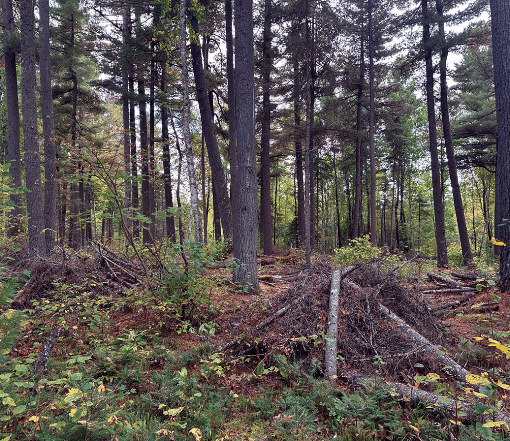
Once the agency approves a plan, crews create burn piles from forest debris, such as tree cuttings left over from timber harvests. Ground crews usually ignite burn piles using drip torches. Once ignition begins, crews manage the fire line usually by using fire hoses. After the burn, the forest quickly regenerates, encouraging new growth and a healthy understory.


Locations & maps
The agency released a list of locations and maps where prescribed burns will take place throughout the forest. The Forest Service plans to continue prescribed burning projects through December, as long as conditions remain optimal. During active burning, drivers and nearby visitors may see smoke and flames from roads and areas near the burn unit.
While almost 4,600 acres were scheduled for prescribed burns in the spring, 3,600 acres are slated for burning this fall. In preparation for their work, the agency also notifies the public and local communities about upcoming burns by posting advisories on their website, along roads, at campgrounds, and in other forest access areas.
Superior National Forest (Western Region)
Burntside Pile Burn Units
- Crab Creek-–T63N, R13W, Sec17 (40 acres)
- Cool Crab–T63N, R13W, Sec19 (23 acres)
- Pine Peaks East–T63N, R13W, Sec1 (18 acres)
- Pine Peaks West–T63N, R13W, Sec1 (17 acres)
- Twin Shoreline–T63N, R13W, Sec1 (14 acres)
- Twin North–T63N, R13W, Sec2 (47 acres)
- Twin South–T63N, R13W, Sec1-2 & 11-12 (48 acres)
- Twins-T63N, R13W, Sec1 & 12 (31 acres)
- Twin Point–R63N, R13W, Sec 11-12 (57 acres)
- West Twin Point–T63N, R13W, Sec11 & 14 (34 acres)
- Chant Point–T63N, R13W, Sec14 (18 acres)
- Hunch Creek–T64N, R13W, Sec13 (29 acres)
- North Everett–T64N, R12W, Sec31 (12 acres)
Lake Vermilion Pile Burn Units
- Bystrom Bay–T63N, R16W, Sec28 (5 acres)
- North Pine–T63N, R16W, Sec26&27 (3 acres)
- Rice Bay South–T63N, R15W, Sec34
Superior National Forest (Eastern Region)
Gunflint Pile Burn Units
- Reindeer 2 –T61N, R2W, S32 (57 acres)
- Heavyweight 1-4–T60N-61N, R2W, Sec11-14, 21 & 31 (370 acres)
- Hound 3–T61N, R1W, Sec10 (54 acres)
- Nova 4–T60N, R2E, Sec7 (39 acres)
- Atlas–T63N, R1E, Sec15 (6 acres)
- Rescue 7, 8, 10 & 11–T64N, R1E, Sec20,21, & 27 (193 acres)
- East Bearskin 1 & 2–T64N, R1W, Sec12 (130 acres)
- Squint–T64N, R1W, Sec9 (118 acres)
- Hungry Jack–T65N, R1W, Sec34 (152 acres)
- Flour–T64N, R1W, Sec 1,2, & 11 (138 acres)
- Caribou–T65N, R1W, Sec33 (68 acres)
- Seagull Guard Station–T65N, R4W, Sec9 (10 acres)
- Airport–T62N, R1W, Sec23 (40 acres)
- Menogyn–T65N, R1W, Sec34 (12 acres)
- Cross River–T65N, R4W, Sec26 (40 acres)
- Greenwood–T61N, R2W, Sec14 (40 acres)
- East Bearskin–T64N, R1W, Sec 11 (40 acres)
- Pike Lake–T61N, R2W, Sec14 (40 acres)
Tofte Prescribed Pile Burn Units
- Eddy 1, 2, 7, 10, 11, 14 & 17–T61N, R9W, Sec 15, 16, 21 & 22 (171 acres)
- Fry 4 & 5–T60N, R4W, Sec8, 9, 15 & 15 (28 acres)
- Little Isabella Campground–T60N, R9W, Sec25 (14 acres)
- Isabella Compound–T59N, R8W, Sec5 (5 acres)
- Harriet Pit–T60N, R6W, Sec29 (40 acres)
- Crooked Pit–T59N, R6W, Sec10 (40 acres)
- Caribou Pit–T59N, R3W, Sec3 (40 acres)
- Tofte Compound–59N, 4W, Sec21 (5 acres)
- Starbuck 7, 8 & 10–T60N, R8-9W, Sec3, 8, & 36 (79 acres)
- Slither 1, 5, 6, & 8-10–T58N, R8&9W, Sec1, 13-14, and 31 (99 acres)
- Cowboy 2, 4 & 6–T59-60N, R7W, Sec4&33 (26 acres)
- Sofa 6–T61N, R6W, Sec19 (17 acres)
- Ninemile 3&4–T59N, R6W, Sec22 (84 acres)
- Kosmo 1, 3, 4, 6-10, 12-17–T59N & 60N, R5W, Sec3, 9, 21, 23-24, 26-27 & 33 (645 acres)
- Tail 3, 4 & 5–T61N, R4&5W, Sec19, 24 & 32 (36 acres)
- Frisk 6, 7, 10 & 12–T60N, R4W, Sec8-9 & 15-16 (221 acres)
- Breezy 2–T60N, R3W, Sec18 (8 acres)
- Babble 12 & 15–T61N, R3W, Sec2 (77 acres)
All of these areas lie outside the Boundary Waters Canoe Area Wilderness (BWCAW). The USFS has not conducted any prescribed burns in the BWCAW since 2010 due to factors like the Pagami Creek Fire, limited funding, and unfavorable weather. However, after recently reviewing and reaffirming its original 2001 decision, the agency determined it can now complete prescribed burns on the remaining 19,917 acres of its treatment plan. This clears the way to resume prescribed burning under the existing plan. That said, the USFS has not published any dates for when it may carry out these burns.
You can find up-to-date information on current prescribed burns in the national forest online.

More info:
- Prescribed Fire Notice – USFS-Superior National Forest
- What is prescribed fire? – USFS-Superior National Forest
- Boundary Waters Canoe Area Wilderness Fuel Treatment Final Environmental Impact Statement