

 Named for an early explorer,
LaVerendrye Provincial Park offers
backcountry camping, and a walk
on the Canadian side.
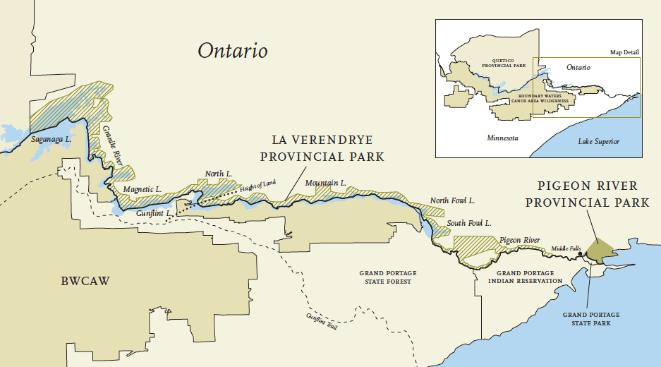
LaVerendrye is a Waterway Provincial Park spanning the distance from Saganaga Lake at the eastern end of Quetico Provincial Park to the lower falls on the Pigeon River. The waterway runs along the Canadian side of the Minnesota/Ontario border, and connects Quetico Provincial Park to the Boundary Waters Canoe Area Wilderness. Once part of an historic fur trade route, today LaVerendrye is part of the Canadian Heritage River system. It encompasses scenic cliffs, mesas and waterfalls, and protects several types of rare and unusual plants. The Height of Land that crosses the park between North and South Lakes is the
point where water flows eastward to the Atlantic and westward to the Arctic Ocean. Park Boundaries The Park’s southern boundary is the International Border between Ontario, Canada and Minnesota. The northern boundary extends 200 yards inland from the shoreline along
the majority of the Waterway.
Park Facilities and Activities There are no visitor
facilities, but backcountry camping and car
camping is permitted, and there are established
trails and portages throughout the park. The park
is used by canoeists, hikers, boaters, and
fishermen, and offers winter activities including
cross-country skiing and snowmobiling.
Camping The park encourages low-impact camping,
allowed at established campsites only. These
sites can be found from Saganaga Lake, along the
Granite and Pine Rivers, to North Lake.
LaVerendrye is classified as a ‘Non-Operational
Park’ and no entry fees or permits are required.
There is a limit of 9 individuals per campsite,
though there is no quota for groups entering the
park. Car camping is allowed on Mountain Lake
and North Fowl Lake.
Access to the park is available on Red Sucker
Bay on Saganaga Lake, Gunflint Lake, Mountain
Lake, and North Fowl Lake.
Camping is not allowed in areas that are set
apart to preserve rare plant species or natural earth
formations; these areas are limited to hiking and
backcountry travel. These ‘Natural Reserve Zones’
include the eastern tip of North Lake, the Arrow
River, portions of North and South Fowl Lakes,
and areas along the Pigeon River.
Park Management of Natural Resources
Commercial forestry and logging is not permitted
within LaVerendrye. Campers are allowed to
cut dead trees for campfires, and park officials
may remove trees that are diseased or pose
safety hazards.
Park waters are monitored to determine
water quality. Certain lakes are stocked with fish,
and fishery levels are studied and maintained –
park officials work with the State of Minnesota to
determine the length of season and catch limits.
Wild fires are suppressed within the park
boundaries to protect the safety of visitors, and
area residents.
The use of motorboats is allowed throughout
the park, except in the protected ‘Wilderness Area’
from the Granite River to the entry of Magnetic
Lake. Snowmobiles are allowed in limited areas,
and motorized all-terrain vehicles and off-road dirt
bikes are allowed in designated areas near main
access points.
For More Information
Northwest Zone
Suite 221
435 James Street South
Thunder Bay, ON P7E6E3
Phone: (807) 475-1495
http://www.ontarioparks.com/