


The U.S. Forest Service entered the fall burn season determined to carry out as many prescribed burns as possible in the Boundary Waters Canoe Area (BWCA), including several that they were unable to complete during the fall of 2001 and spring of 2002.
This fall’s goal was to reduce the backlog of planned burns and eliminate approximately 11,000 acres of extremely dry wildfire fuels that resulted from the huge 1999 blowdown storm. Fire teams worked quickly during a two-week window of dry, sunny weather in mid-September, completing 3,700 acres of burns – more than three times the 1,000 acres that were burned the previous fall.
They had hoped for another burn window during October but cold, wet weather put a halt to prescribed burning for 2002. In 2001, only one-fourth of planned acreage was burned; the proportion improved to one-third in 2002. A seven-year plan calls for burning 75,000 acres of blowdown-created wildfire fuels and creating a patchwork of burned areas that can hold wildfires in check in and around the BWCA.
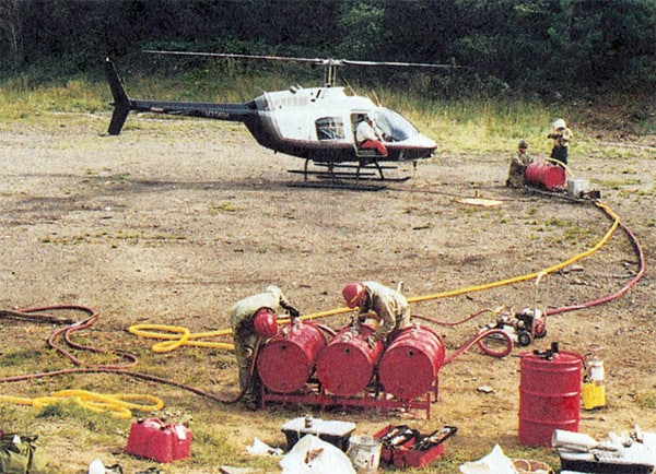
flight to the Three Mile Island/Seagull Lake prescribed burn
area. The staging area, a gravel pit, is located off the Gunflint
Trail. Photo courtesy of Jim Wiinanen, Wilderness Canoe Base
Of the priority areas for this fall, prescribed burns were completed at: Magnetic Lake, 2,486 acres; Iron Mash/Overlap/Meditation Lake, 169
acres; and Three-Mile Island, 1,034 acres. Those burns were in the East Zone of the Superior National Forest near the Gunflint Trail. Crews were
not able to complete East Zone burns at Kekekabic Lake, One-Island Lake and Dogleg Lake, nor planned West Zone burns near Ely between
Snowbank and Moose lakes, at Horseshoe Island, Wind Lake, Wood Lake, the four-mile portage between Fall and Basswood lakes and Knife Lake.
Jim Sanders, Forest Service supervisor of the Superior National Forest, said officials were extremely pleased with what was accomplished this year
during a “phenomenal September” and said no burn window opportunities were missed in 2002.
“When you put the whole picture together, we’re sitting in great shape,” he said. “We’ve completed the burns that were most difficult to accomplish, that carried the highest risk level and cost the most because of their proximity to populated areas. We have a couple more of those to do – near Snowbank Lake and at the end of the Gunflint corridor – but we’ve created a great anchor and the risk goes down as we begin to work our way into the wilderness.”
Sanders said the initial focus was along the Gunflint corridor, which has high public use, and is now moving into the BWCA. Results of the burns done so far have been excellent, he said. For example, the relatively cool prescribed fires have succeeded in maintaining soil conditions so that new seedlings will sprout right away. In addition, approximately 70 percent of the older trees that were not blown down in 1999 remain in areas such as Three-Mile Island where burns have been completed.
“Our objective is to prevent a wildfire that would threaten the health and safety of people in the area,” he said. “The danger of a big fire is
still there; that won’t be gone for 10 to 15 years until we’ve completed the burns and everything has decomposed. But with what we’ve accomplished, we have more options and better ability to control a wildfire.”
Master Plan, Weather Woes
The Forest Service’s master plan calls for prescribed burns in the BWCA to be completed over a five- to seven-year timeframe, starting with the
signing of the Environmental Impact Statement (EIS) September of 2001. Acreage goals spike in year four. Burns are planned for periods in the fall and spring when materials are dry enough, but not so dry that a prescribed fire could easily become an uncontrollable wildfire. Jim Hinds, fire management officer for the West Zone of the Superior National Forest near Ely, said: “It’s not going to be easy by any means; it’s a real aggressive program.”
Weather conditions are crucial to prescribed burning – and extremely unpredictable. The last several falls have been uncharacteristically wet. In the fall of 2001, an additional challenge was that aircraft used for the burns were grounded after the September 11 disasters and later were
diverted to fight western wildfires. Last spring, Forest Service officials said the burn window never opened because conditions went from wet to hot and dry almost overnight. The summer was relatively dry, with campfire restrictions imposed in May, lifted in late June and imposed
again in July. In early July, crews fought to contain a wildfire between Hovland and Grand Marais that started in trees that had been blown
down in a storm 10 years ago, and 1,400 Superior National Forest employees spent much of the summer on the road assisting crews fighting huge wildfires burning in the western United States. Fortunately, the need for national firefighting resources out west dropped off as the September burn window opened in the BWCA. This winter the Forest Service will critique the 2002 burns, make detailed plans for 2003 and hope to be able to do some burning in the spring. Spring burns would take place between mid-April and mid-May, after the snow is gone and before things begin greening up. Lee Frelich, a forest ecologist with the University of Minnesota, said last summer that he hoped the Forest Service would be able to complete a large number of burns in 2002 and 2003. After that, he said, seeds in the cones of downed jack pine trees will be dead, and a different type of forest dominated by aspen would come back in the wake of a burn.
“Ideally, they would have started the burning sooner,” Frelich said. “At this point, I would try to stick with the plan. But if it rains in September for the next few years, they’re not going to get it done.” In Frelich’s opinion, the EIS for the burn plan took a long time to complete because the Forest Service approached the burns from a public safety perspective rather than a benefit to the ecosystem, which he said would have been more compatible with the Wilderness Act. Sanders said two EIS’s were completed in 18 months, which is a very fast pace. He said the prescribed burn plan is benefiting both public safety and the health of the wilderness.
Divergent Views on Danger
Opinions about fire danger and priorities in the BWCA reflect the independent nature of the people who live in northeastern Minnesota.
“People in this area are generally very supportive of the prescribed burning and glad to see what we’ve been doing,” Sanders said. “There are very few communities who’ve taken on preparedness themselves like the Gunflint has.”
Cook County Sheriff Dave Wirt agreed, saying residents understand the need for a conservative, cautious approach to the prescribed burns. He noted that some people still advocate mechanical harvesting of downed trees to salvage the lumber, but that any action on that front is
unlikely because logging is not allowed in the area and could not happen without Congressional approval.
Hinds said he is a strong supporter of using prescribed burning in the wilderness to help restore ecological balance in areas such as the BWCA where nature’s fires have been suppressed for many years, but he knows there is a lot of opposition to his stance. Forest Service policy has long supported prescribed burning for fuel hazard reduction, he said, but has not viewed it as an ecological tool for wilderness
management.
Frelich of the University of Minnesota said the rapid growth of dogwoods in the blowdown area is shading fallen logs, which are rotting more quickly than expected. But Sanders and Ellen Bogardus-Szymaniak, a fire behavior specialist with the Forest Service, said that while the shade will keep humidity levels up and delay the timing of the fire season, drying fuels from the blowdown remain and it will be many years before decomposition will mitigate the wildfire danger.
Dan Baumann, president of the Cook County Fire Chiefs Mutual Aid Association and owner of Golden Eagle Lodge, believes the Forest
Service should have started doing prescribed burning years ago, and should use it to reduce wildfire fuels after an area is logged. He said the Forest Service is doing a good job with the BWCA burn plan – balancing caution with action and working well with private property owners. “I disagree with the amount of red tape the Forest Service has to go through to please a small minority of environmentalists,” he said. “It’s
micromanagement. The Forest Service had enough knowledge to do this without going through the whole EIS process.”
Bogardus-Szymaniak said: “Our biggest message is that we will have a fire at some point, and we need to be sure we’re prepared. I don’t have a sense that people are paying attention to this, and it’s easy after two or three years to think that there isn’t going to be a big fire if there hasn’t been one yet. That’s not the case.”
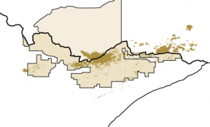
Priority Prescribed Burns in the BWCAW
1. Little East Creek Project
465 acres completed 2001
2.Wood Lake 580 acres planned
3. Sommers 277 acres planned
4. Snowbank Lake 1,372 acres planned
5. Horseshoe Island 54 acres planned
6. Thunder Point 386 acres planned
7. Bonnie Lake 848 acres planned
8. Three Mile Island 1,034 acres completed 2002
9. Meditation Lake 129 acres completed 2002
10. Arc Lake 2,633 acres planned
11. Tuscarora Lake 2,112 acres planned
12. Magnetic Lake 1,090 acres completed 2002
13. Saucer Lake 2,369 acres planned
14. Skipper 192 acres completed 2001
15. Meeds Lake 1,626 acres planned
16. Crocodile Lake 731 acres planned
17. Brule River/One Island Lake 313 acres completed 2001
18. Rum/Sled 515 acres planned
19. Bower Trout 1,039 acres planned
This article was published in Wilderness News Winter 2003