


By Diane Rose, Wilderness News Contributor
The Nature Conservancy of Minnesota is making two land purchases that will help preserve the scenery, history and unusual ecosystem of the Pigeon River border area between Minnesota and Ontario.
In early March – with help from its independent partner,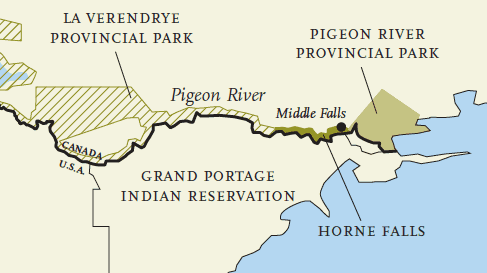 Nature Conservancy of Canada (NCC), Ontario Provincial Parks and a Quetico Superior Foundation contribution – the Conservancy purchased the last unprotected seven miles of river frontage on the
Canadian side of the river from the Purnell family of Milwaukee. The 750-acre purchase, known as Horne Falls, extends from LaVerendrye Provincial Park to
Middle Falls, where it adjoins Ontario’s Pigeon River Provincial Park.
The partners in the transaction plan to work with the Ontario Ministry of Natural Resources to turn Horne Falls over to Ontario Provincial Parks within
the next year. The Nature Conservancy and its supporters will contribute half the cost of the project. Ontario Provincial Parks will contribute the other half through an agreement with NCC to add ecologically significant parcels to the parks.
Both sides of the river have stately pine forests and Rove shale formations. Known as Rove Hills, these formations have sheer cliffs of exposed soft
shale on their northern slopes. They provide habitat for plants typically found in alpine and arctic ecosystems, including an assortment of ferns and woodsia, also known as rock ferns. Some of the plants are quite rare, including: encrusted saxifrage, an herbaceous
plant with small cream-colored flowers; wartyfruited fairy bells; and sticky locoweed, a legume with purple flowers.
“This is very beautiful, wild, spectacular country,” said Tom Duffus, northeast Minnesota program director for The Nature Conservancy. “Our goal is to protect the watershed and unique habitats that make this one of the Great Lakes’ last great places. We want to help heal and protect the river and its biodiversity for future generations.” An example of challenges associated with the parcels, Duffus said, is that historic logging has reduced the number of conifers in the area. That has resulted in soil erosion, faster snow melt and rapid fluctuations in water levels. Restoration of the forest and trail management to safeguard plants from trampling are two of the Conservancy’s goals for the area, he said.
The areas that The Nature Conservancy has purchased are part of the Canadian Heritage River system and the historic Voyageur Waterway. In the 1700s and 1800s, this was known as the Grand Portage trading route and was a key waterway used by the French and British explorers and fur traders. For centuries before that, it was an important travel route for the Cree, Assiniboin Dakota and Anishinaabe (Ojibwe or Chippewa) peoples. Logging and river drives became the dominant activity in the early 1900s, and today the area is a favorite wilderness destination for campers, canoeists and hikers. Most of the land along the waterway, which includes a series of border lakes and the Pigeon River, has long been protected in parks, state forests and other public lands. To the south of the waterway, from west to east, are the Boundary Waters Canoe Area, Grand Portage State Forest, Grand Portage Indian Reservation and Grand Portage State Park. To the north are Quetico Provincial Park, LaVerendrye Provincial Park and Pigeon River Provincial Park.
The Conservancy also plans to purchase the last unprotected stretch of property on the American side of the river. The 100-acre parcel includes approximately one mile of river frontage on the U.S. side, and would complete the chain of protected lands on both sides of the border lake country.
This article appeared