Skip to content
  • NEWS
    • SUBSCRIBE
    • ARCHIVES
  • FIRE
  • MINING
  • ENVIRONMENT
  • PARKS
    • Boundary Waters Canoe Area Wilderness News
    • Quetico Provincial Park News
    • Voyageurs National Park News
    • Special Places
  • HISTORY
  • PARTNERS
    • Events
    • Canoe Camps
    • Organizations
  • ABOUT
  • DONATE
  • HOME

glifwc

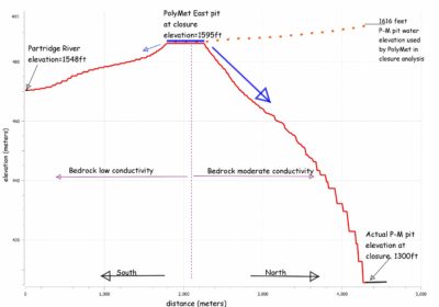
DNR: Miscalculation in PolyMet Analysis Means Pollution Might Flow Toward the Boundary Waters

December 9, 2015December 9, 2015 by Greg Seitz

Incorrect data led to previous predictions that groundwater would flow south.

Supporting the protection of the Minnesota-Ontario border region and Superior National Forest including the Boundary Waters Canoe Area Wilderness, Quetico Provincial Park, Voyageurs National Park, La Verendrye Provincial Park, Isle Royale National Park, and Lake Superior. Published by the Quetico Superior Foundation Since 1964. More About Us >
Follow us:


Help us preserve the wilderness character of canoe country for future generations.


Quetico Superior Wilderness News is published, in part, with a contribution from the Andrews-Hunt Fund of The Minneapolis Foundation.
CATEGORIES
TOP STORIES
  • 8 must-see waterfalls in the Boundary Waters Canoe Area Wilderness 4.8k views
  • Towboat regulations for BWCAW are back in court 2.1k views
  • Everything you need to know about the new BWCA food storage order 1.5k views
  • Wildfires burn in the southern part of the Superior National Forest 1.5k views
  • Trump administration prioritizes NorthMet mine in Northern Minnesota 1.5k views

INSTAGRAM

Instagram
All material © 2025 Quetico Superior Foundation | Web Site Privacy Policy & Terms of Use

Supporting the Protection of the Minnesota-Ontario border region and Superior National Forest including the Boundary Waters Canoe Area Wilderness, Quetico Provincial Park, Voyageurs National Park, La Verendrye Provincial Park, Isle Royale National Park, and Lake Superior. More About Us >