


Northern Minnesota’s canoe country is famous for its clean, cold, and clear waters. Thanks to the geologic history, undeveloped watersheds, and other factors, the region’s lakes have been referred to as “crystalline,” “gin clear,” “transparent,” “glassy,” and more over the millennia.
In places, a paddler can look down and see a rocky lake bottom far below. It gives the impression of floating through the atmosphere, suspended between Earth and sky. This clarity is cherished by many visitors to the Boundary Waters Canoe Area Wilderness and the surrounding area. The water appears pure and pristine, perfect for drinking, swimming, fishing, and much more.
Which of the Boundary Waters’ 1,200 lakes are clearest can be an interesting discussion among those who have spent time in the wilderness. Some scientists have attempted to provide as close to a definitive answer as possible, thanks to advanced technology and complex computing.
Satellite technology
The typical way of measuring water clarity is for someone in a boat to lower a Secchi Disk into the water. When the black-and-white, foot-wide disk disappears from view, the observer records a measurement of its depth. But, that takes a lot of time to get even just one sample, and is certainly not feasible on remote wilderness lakes.
The University of Minnesota’s Remote Sensing and Geospatial Analysis Laboratory has developed technology to analyze satellite imagery provided by NASA to estimate water clarity on more than 10,000 of Minnesota’s lakes. The measurements are all available to view on the LakeBrowser map website.
“Recent advances in satellite technology (improved spatial, spectral, radiometric, and temporal resolution) and atmospheric correction, along with cloud and supercomputing capabilities, have enabled the development of automated regional-scale measurements of water clarity,” the lab wrote. “These new capabilities provide opportunities to improve lake and fisheries management by measuring more variables (chlorophyll, colored dissolved organic matter (CDOM), and total suspended matter, the main determinants of water clarity) more frequently.”
Accurate assessments
The method has been published in peer-reviewed journals and is generally considered accurate. Researchers determined the accuracy by taking Secchi Disk measurements on some lakes and comparing them to clarity computed by the satellite computer model. Nonetheless, the data should be considered a good estimate of clarity, not a precise measurement — an interpretation of information collected remotely.
The data we use is the annual mean from 2008, the most recent year for which data is available. Conditions on any given lake on any given day may differ.
We’ve broken the rankings into two categories. The first looks at all lakes (larger than 10 acres), while the second includes only large, more well-known lakes (more than 500 acres).
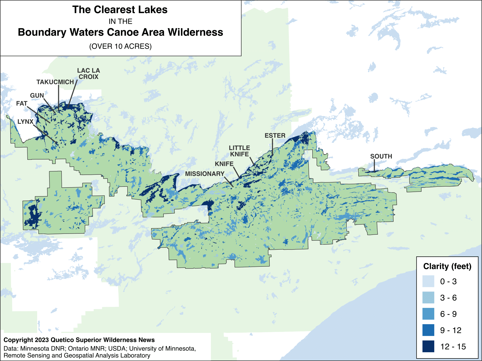
Top ten clearest lakes
| Rank | Lake name | Clarity (feet) |
|---|---|---|
| 1 | Fat Lake | 16.24 |
| 2 | Missionary Lake | 15.39 |
| 3 | Takucmich Lake | 14.80 |
| 4 | South Lake | 14.67 |
| 5 | Ester Lake | 14.57 |
| 6 | Gun Lake | 14.47 |
| 7 | Knife Lake | 14.47 |
| 8 | Little Knife Lake | 14.44 |
| 9 | Lynx Lake | 14.27 |
| 10 | Lac la Croix | 14.21 |
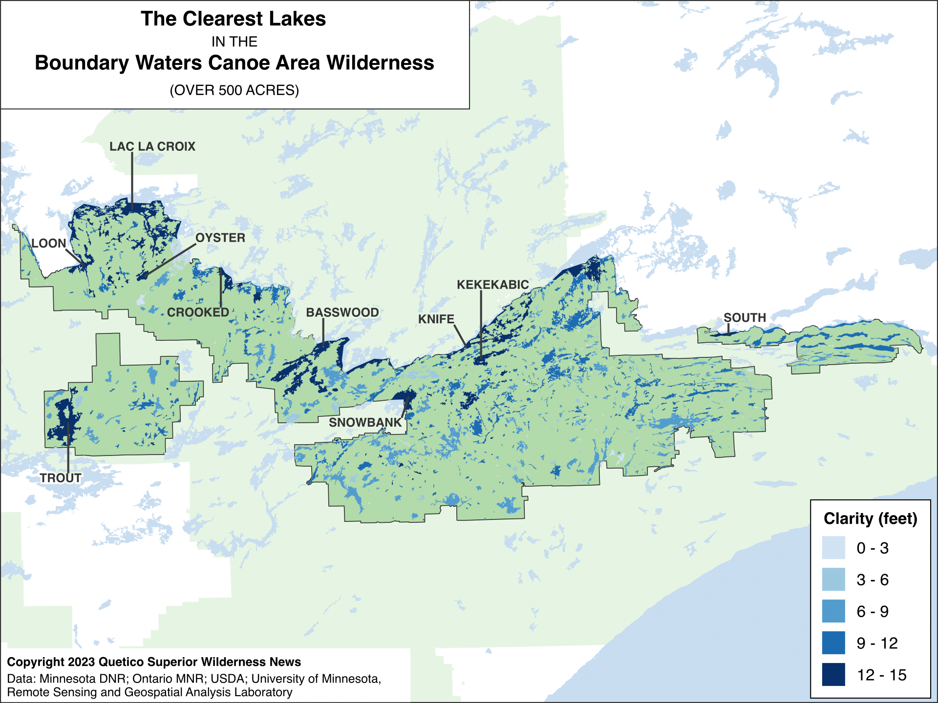
Top ten clearest lakes over 500 acres
| Rank | Lake name | Clarity (feet) |
|---|---|---|
| 1 | South Lake | 14.67 |
| 2 | Knife Lake | 14.47 |
| 3 | Lac la Croix | 14.37 |
| 4 | Trout Lake | 13.85 |
| 5 | Loon Lake | 13.81 |
| 6 | Kekekabic Lake | 13.22 |
| 7 | Crooked Lake | 13.12 |
| 8 | Oyster Lake | 12.86 |
| 9 | Snowbank Lake | 12.63 |
| 10 | Basswood Lake | 12.57 |
Reference
Leif G. Olmanson, Marvin E. Bauer, Patrick L. Brezonik, A 20-year Landsat water clarity census of Minnesota’s 10,000 lakes, Remote Sensing of Environment, Volume 112, Issue 11, 2008, Pages 4086-4097, ISSN 0034-4257, https://doi.org/10.1016/j.rse.2007.12.013.