

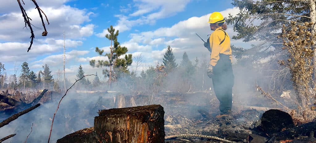
Wildfire is a normal part of healthy ecosystems in the Superior National Forest. However, USFS personnel are warning that this spring could see a higher incidence of wildfires due to low snow cover and precipitation. As a result, they encourage those who live and recreate in the region to be watchful.
Urging caution
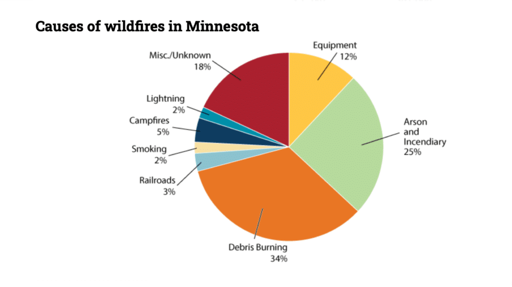
Wildfires are starting earlier in the spring and lasting later into the fall. Roughly 34% of wild-land fires in the state are caused by debris burning while a total of 7% are as a result of lightning or campfires.
According to Nick Petrack, SNF/CNF Fire Management Officer, “Staying vigilant in fire prevention year around is key, especially during dry and warm conditions. We are gearing up earlier on fire prevention messaging, wildland firefighter crew preparedness, and focused on working with our communities to reduce vegetation across more fire-prone landscapes.”
Wildfires in 2023
Minnesotans will recall last year’s fire season beginning in early March. By early May, significant wildfires burning in Saskatchewan and Alberta had sent plumes of smoke into parts of the state. As a result, June was marked by poor air quality.
The Boundary Waters Canoe Area Wilderness (BWCAW) experienced a wildfire early on in the summer of 2023. The Spice Lake fire began in mid-June. In order to contain the fire, a 100,000-acre emergency closure was initiated. By the end of the month, lakes with direct impact had been opened. Located on the eastern side of the wilderness, the fire was believed to be human-caused. By the end of the season, 813 wildfires covering more than 8,600 acres had spread throughout the state.
Seasonal comparisons and spring forecast
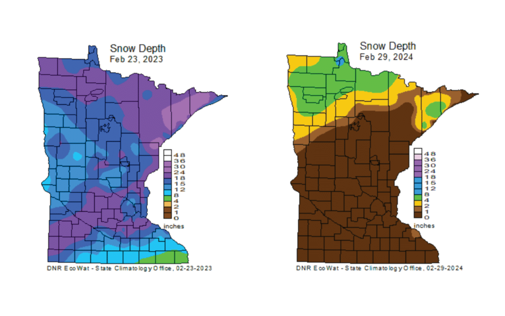
At a glance, it’s easy to tell that the Quetico Superior region is well below normal snow levels. Maps show drastic differences from 2023 to 2024. Reports indicate that Duluth has averaged just seven-tenths of an inch of snow in February compared to average depths of 15 inches. Most of northern Minnesota has less than 4″ of snow cover. The National Interagency Fire Center is predicting a higher-than-normal potential for fire in the upper Midwest. They report that, “a late January warm spell across the northern Plains into the Great Lakes resulted in temperature anomalies up to 30 degrees above normal.”
Prescribed burns
The USFS conducts prescribed burns throughout the season when conditions are right. Using specific guidelines, they’re carefully managed so that humans and property are protected. Prescribed burns reduce fuel loads, lessening the likelihood of a high-intensity wildfire.
Numerous elements come into play when planning a burn. It includes evaluating weather and forest conditions, resource availability for response, and adherence to forest management plans regarding fire management. Above all, the priority is firefighter and public safety.
The spring season is shaping up to be drier than normal. Unless springtime weather trends wetter, it could be a busy season for wildland management. Burning restrictions are in place in some areas. Current fire restrictions and maps can be found on the MNDNR’s webpage.
Avoiding human-caused wildfires
Central Minnesota is already at a level of high probability of wildfires due to dry conditions. It may not be long before the northern part of the state follows suit. The USFS has provided guidelines for fire safety, prevention, and burning:
- Do not dump hot embers in the woods.
- Do not light off fireworks or use matches carelessly.
- Avoid parking a vehicle over tall, dry grass (vehicles cause more acreage burned than any other equipment).
- Campfires in the BWCAW and developed campgrounds in the SNF are only allowed in a designated fire grate or ring.
- Avoid campfires or burning near tall vegetation.
- Have water nearby in case the fire gets out of control or leaves the fire grate area.
- Extinguish your fire completely by drowning, stirring and drowning it again. Feel the area to be sure it’s completely out.
- Keep up to date on current wildfires through an app such as Watch Duty: Wildfires.
- Provided by the USFS, InciWeb is an interagency all-risk incident web information management system where you can search incidents throughout the state. It includes information on the type of fire, acreage, and containment.
More information:
- Spring 2024 Wildland Fire Outlook FAQs – USFS – Superior National Forest
- Record low winter snow cover may boost spring fire danger
- Wildland fire information – MNDNR
Wilderness guide and outdoorswoman Pam Wright has been exploring wild places since her youth. Remaining curious, she has navigated remote lakes in Canada by canoe, backpacked some of the highest mountains in the Sierra Nevada, and completed a thru-hike of the Superior Hiking Trail. Her professional roles include working as a wilderness guide in northern Minnesota and providing online education for outdoor enthusiasts.