


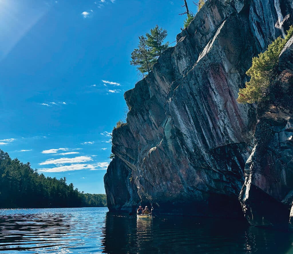
Where the churning waters of Lower Basswood Falls pour into Crooked Lake, the past feels close at hand. For thousands of years, Indigenous people have paddled this ancient water trail, hunting, fishing, and building families and communities along its shores. Just beyond the falls, a granite wall bears a striking series of pictographs—one of dozens scattered across the Boundary Waters—that speak to the enduring presence of the Anishinaabe (Ojibwe) people, who continue to hold this land sacred.
Tracing the Voyageurs’ route
On a recent canoe trip, a group of women paddled the watery border between two countries. Canada stretched to our right, the United States to our left. But the boreal forest and granite shoreline looked the same on both sides. Only small metal monuments, firmly anchored in granite, sporadically marked the international line in the Boundary Waters Canoe Area Wilderness (BWCAW).
We followed a water trail punctuated by portages that wound around scenic cascades. Some of the deeper pools looked like they might hold fish. This is rugged and remote country. To the north lies Quetico Provincial Park, a million-acre, watery landscape of thick forest. The nearest town sat two or three days’ paddle to the south. We didn’t see a single person all day as we made our way west, first from Upper Basswood Falls into the Basswood River, then eventually to Lower Basswood Falls, where the water flows into Crooked Lake.
Midday, a moose appeared along the Canadian shoreline. She studied us for a moment before slowly disappearing into the dense woods. These elusive, majestic creatures are rarely seen.
We camped at a site facing two chutes of the Lower Basswood Falls. The sound of tumbling, frothing water drowned out all other noise. As the sun set, golden droplets danced in the fading light. A good end to a full day.
The next morning, we paddled north on Crooked Lake. This stretch of water once served as a major route for French fur traders, the Voyageurs, who began traveling it in the 1730s. They carried beaver pelts and trade goods between remote Canadian forts and Grand Portage on Lake Superior. At that time, the route included about thirty-six portages between Lake Superior and Rainy Lake. Crews of four to six men paddled north in lightweight canoes, enduring a grueling two-week journey.
History along the border country
But long before the Voyageurs arrived, others had traveled and lived along these waterways. Archaeological evidence shows that people have inhabited this northern landscape for thousands of years. Artifacts found along the border suggest people began using quarries to collect rock for projectile points as early as 13,000 years ago. While there’s no evidence yet from the early Woodland era in this area, objects from the later Woodland period, around 1,000 years ago, have been discovered.
The region was once sparsely populated by Sioux communities. When the Ojibwe moved in from the east, the Sioux moved west. The Ojibwe made this region their home, living, hunting, and fishing across a vast network of lakes and rivers. They left little physical evidence behind, but the pictographs scattered across the wilderness may be part of what remains.
Voices on the rocks
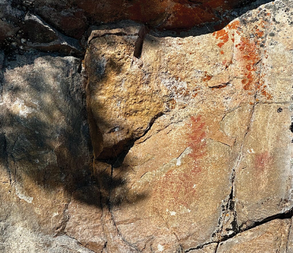
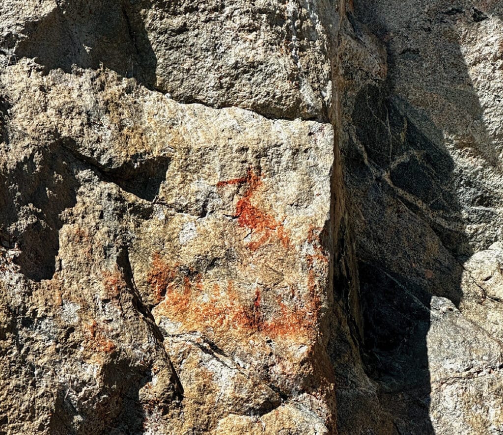
At least forty pictograph sites have been documented throughout the Boundary Waters. These images, often animals, human figures, or symbolic shapes, represent some of the earliest forms of communication. Their meanings remain uncertain, but researchers believe some may symbolize constellations, historical events, or cultural traditions. Most date back between 500 and 1,000 years. With careful observation, you can see them scattered along the folds of granite rocks. It is thought that they were created by using a red ochre pigment mixed with ingredients such as sturgeon cartilage and bear grease. Using fingers or sticks as paintbrushes, the artist forged a lasting connection to the stone.
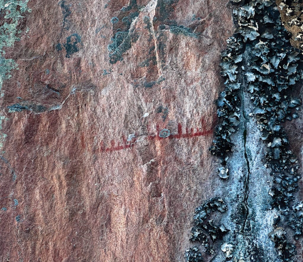
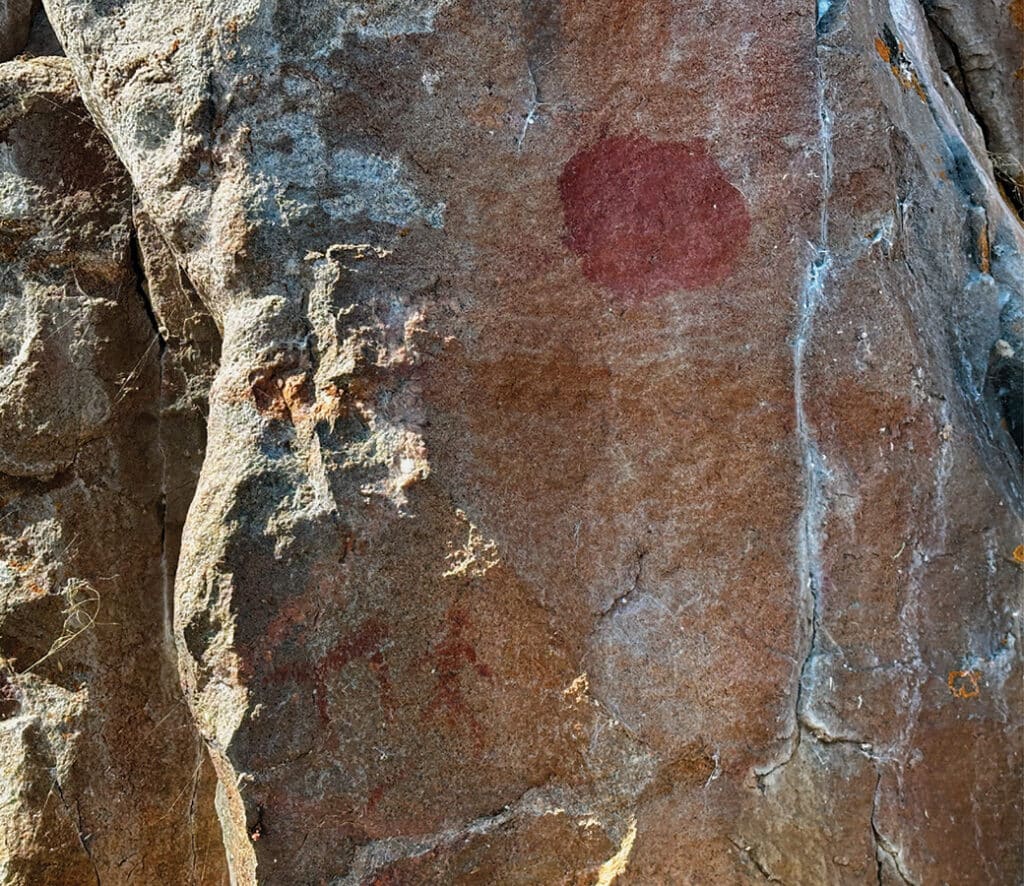
As we approached a dramatic granite shelf, streaks of black, gray, red, and orange colored the stone. Stains from rainwater and patches of lichen were taking over. Slowly, as we paddled past, the pictographs began to reveal themselves. The first image looked like an animal with a long tail; perhaps a mink.
Then we saw the best-known trio: a group of rust-colored moose, high on a prominent section of rock, two adults and what appeared to be a calf. Nearby, a crane stood above a canoe filled with people. We drifted along the rock face, letting our eyes adjust. Our gaze drew upward as we paused, searching. More images emerged: another human figure, a circular shape resembling the sun or moon, more canoes, some showing adults and children, animal shapes, part of a caribou, and a scattering of Xs. Each time we visit this site, we discover something new.
Tread lightly
Seeing these ancient images stirs something deep. Floating quietly beneath the cliff, we imagine the people who once passed through. Who were they? What did they want to express? Did they ever return? These images remind us of the sacredness of this place. They remind us to move through it with respect and to tread lightly.
Some pictographs, such as those on North Hegman Lake, can be visited on a day trip. Most, including the Crooked Lake site, require two or more days of canoe travel. If you visit, please don’t touch the images. Oils from human skin will degrade them over time.
These sites remain culturally important to Indigenous communities today. This is the traditional homeland of the Anishinaabe, in this region known as the Ojibwe people. The Grand Portage, Fond du Lac, and Bois Forte Bands of Chippewa still hunt, fish, and live in these forests.
You reach the Crooked Lake pictographs via wilderness entry points located on the Echo Trail north of Ely. The closest are Mudro Lake (Entry Point #23) and Fall Lake (Entry Point #24). Reaching the site requires at least two days of paddling through large lakes, rivers, and remote portages. The route is considered moderate to challenging in difficulty based on your group’s experience, fitness, and the conditions. Visiting this area requires careful planning and preparation, as help may be hours away.
For those interested in learning more, Magic on the Rocks by Michael Furtman offers a comprehensive guide to the history and interpretation of these pictographs.
More info:
- USFS Boundary Waters Canoe Area Wilderness Trip Planning Guide
- The Ojibwe People – Minnesota Historical Society
- Archaeologists uncover clues about the first people to use the Boundary Waters – Friends of the Boundary Waters
Wilderness guide and outdoorswoman Pam Wright has been exploring wild places since her youth. Remaining curious, she has navigated remote lakes in Canada by canoe, backpacked some of the highest mountains in the Sierra Nevada, and completed a thru-hike of the Superior Hiking Trail. Her professional roles include working as a wilderness guide in northern Minnesota and providing online education for outdoor enthusiasts.