

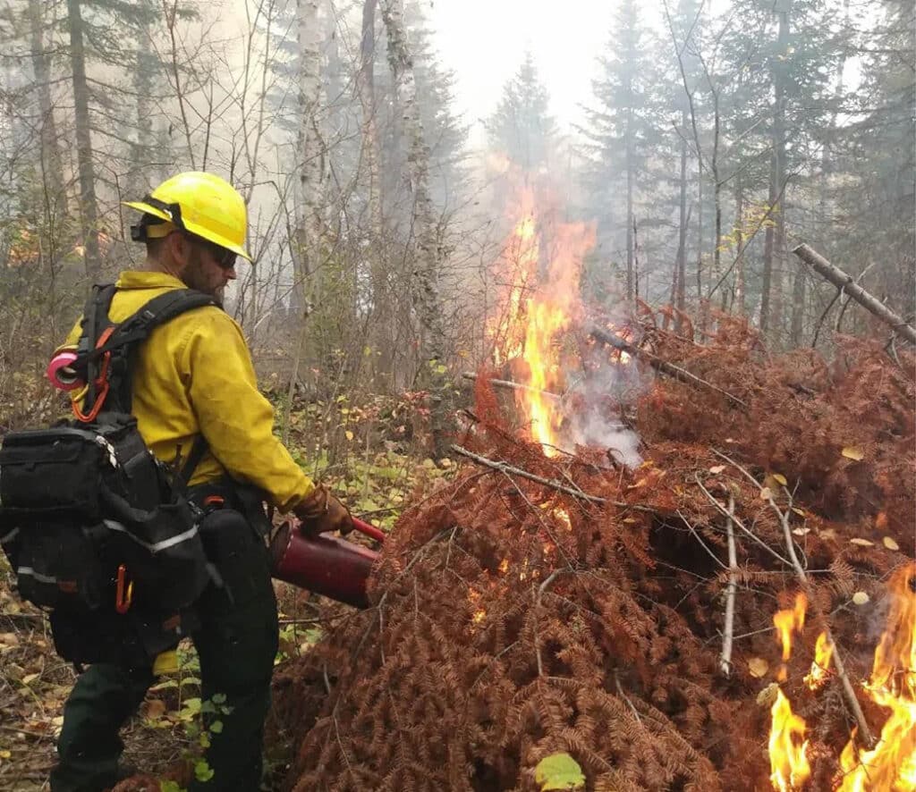
The Superior National Forest (SNF) will conduct multiple prescribed burns across the forest over the next month. They play a key role in supporting a healthy ecosystem by reducing overgrown vegetation while helping to protect nearby communities from wildfires. These controlled burns occur each spring and are part of the Forest Management Plan. We have included a list of locations and maps for upcoming burns.
Forest Service crews will initiate prescribed burns in northern Minnesota over the next few weeks. As a result, some areas may be closed to the public for several days. Before activities begin, they assess conditions based on the weather and other factors. If conditions are unfavorable, they’ll postpone or cancel the burn. To notify the public of their activity, crews will post warning signs along roadways before, during, and after the operation.
The Forest Service emphasizes public and firefighter safety during all burns. When scheduling operations, officials also consider national preparedness levels, available funding, and resource availability.
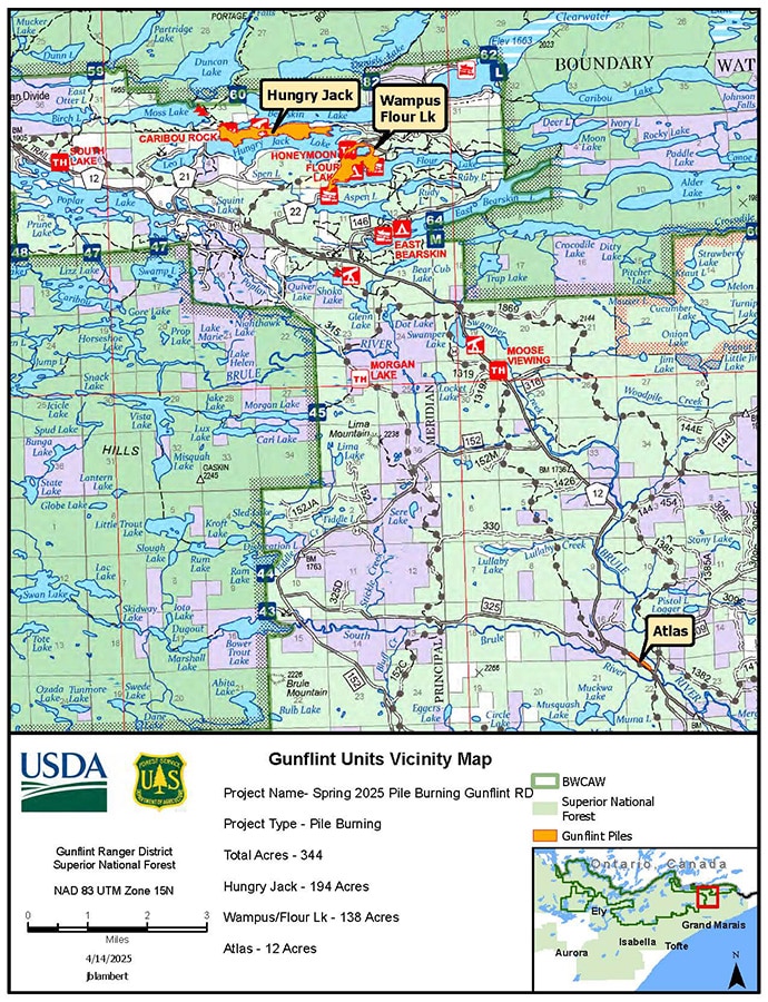
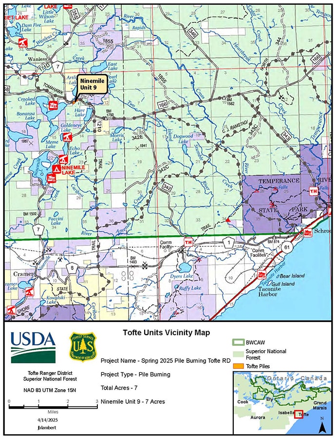
The USFS-Superior National Forest posts maps of prescribed burn locations on social media each week.
Air quality may be affected, and residents and visitors may see or smell smoke. Those venturing into smoky areas can stay safe by slowing down and turning on their headlights. For the latest air quality updates, check your location online.
The agency released a list of locations where prescribed burns will take place throughout the forest. Before crews begin, the Forest Service alerts county emergency management officials about the planned activity.
Superior National Forest (western region)
- Bear Island (121 acres) is located ten miles south of Ely, MN, and one mile east of St. Louis County Highway 21; Township 61N, Range 13W, Sections 10 and 15.
- Canary (60 acres) is located at the intersection of Highway 21 and County Road 120, between Canary and Blueberry Lakes, seven miles south of Ely, MN in St. Louis County; Township 61N, Range 12W, Sections 4 and 5.
- Geraldine (289 acres) is located one-half mile west of the North Arm Rd, east of Geraldine Lake, approximately seven miles NE of Ely, MN; Township 63 North, Range 13 West, Section 4.
- Fenske (212 acres) is six miles north of Ely, MN off County Rd 116 (Echo Trail); Township 64N, Range 12W, Section 30.
- Deer Ridge (119 acres) is located on the Mushroom Island Rd and White Iron Lake, approximately two and on-half miles southeast of Ely, MN; Township 62N, Range 12W, Section 1.
- Fernberg Remote Automatic Weather Station (RAWS) (5 acres) is located at Township 63N, Range 9W, and Section 8.
- Kinmount (97 acres) is located north of Orr, MN, northwest of Ash Lake, and west of Highway 53; Township 67 North, Range 21 West, Sections 20, 27, 28, 29 and 34.
- Norwegian Island-Vermilion Lake (9 acres) is located on the west end of Norwegian Bay of Lake Vermilion, north of Cook, MN; Township 63 North, Range 18 West, Section 13.
- LaCroix Pond (2 acres) is located on the north side of Cook, MN at the LaCroix Ranger District office site; Township 62 North, Range 18 West, Section 18.
- Integrator (139 acres) is located near the junction of County Road 65 and MN State Highway 73, west of Lake Leander and northwest of Virginia, MN; Township 60N, Range 20W, Sections 12, 13, 14, 15, 22 and 23.
- Rosalie (20 acres) is located south of Lake Leander, Lake Fourteen, and County Rd 65 located northwest of Virginia, MN; Township 60N, Range 19W, Sections 22 and 23.
- Lisa (96 acres) is located northeast of Orr, MN and along County Rd 116 (Echo Trail); Township 65 North, Range 14 West, Sections 6 & 7 and Township 65 North, Range 15 West, Section 1.
- Fourteen (87 acres) is located south of Lake Leander, Lake Fourteen, and County Road 65 located northwest of Virginia, MN; Township 60N, Range 19W, Sections 22 and 23.
- Murphy Lake (80 acres) is near the Toimi area, 2 miles south of Murphy Lake and 4 miles east of Brimson, MN; Township 56N, Range 11W, Section 20.
- Jack Pine Bay (48 acres) is located south of Highway 1 north of Virginia, MN and west of Tower, MN; Township 61 North, Range 17 West, Sections 13 and 14.
- Skibo Helispot (7 acres) is located seven miles southeast of Hoyt Lakes, MN; Township 58N, Range 13W, Section 21.
- Skibo Vista (27 acres) is located eight miles southeast of Hoyt Lakes, MN; Township 57 North, Range 13 West, Section 8.
Superior National Forest (eastern region)
- Tanner Lake (226 acres) is six miles east of Isabella off Forest Road (FR) 172 and FR 174 in Lake County, MN; Township 59N, Range 7W, Section 5,8.
- Shack (142 acres) is approximately eight miles northeast of Isabella, along the Wanless Rd; Township 60 North, Range 6 West, Sections 9 and 16.
- Bandit South (92 acres) is approximately 15 miles northwest of Tofte, along FR 1287 or the Two Moose Trail: Township 60 North, Range 6 West, Sections 9 and 16.
- Wildlife management prescribed fire including Hoist Lake (six acres at Township 60N, Range 7W, Section 35, Christmas Tree (six acres at Township 59N, Range 5W, Sections 3 & 4.), Richy Lake (15 acres at Township 59N, Range 5W, Section 3, Plouff Creek (13 acres Township 61N, Range 4W, Section 18).
- Kawishiwi Lakes (1,911 acres) is located 18 miles north of Tofte at the intersection of the Sawbill Trail and the Perent Lake Rd; Township 62 N, Range 5 W, Sections 25, 26, 35 and 36; T61N, R5W, Sec1; T62N R4W Secs 30, 31; T61N, R4W, Sec 6.
- Sunfish Lake (775 acres) is located south of Greenwood Lake, off the Gunflint Trail (Cook Cty 14), in Township 64N, Range 2E, Sections 25,26, 27, 34, 35, and 36 in Cook County.
Those who want to stay updated can find more information and maps on the SNF website, as well as on Facebook, X, and InciWeb. The Forest Service and the Minnesota Department of Natural Resources regularly coordinate fire prevention efforts, fire restrictions, and wildland fire response.
More info:
- Superior National Forest to Begin Prescribed Fires – USFS-Superior National Forest
- Superior National Forest Land and Resource Management Plan – USFS-Superior National Forest