Skip to content
  • NEWS
    • SUBSCRIBE
    • ARCHIVES
  • FIRE
  • MINING
  • ENVIRONMENT
  • PARKS
    • Boundary Waters Canoe Area Wilderness News
    • Quetico Provincial Park News
    • Voyageurs National Park News
    • Special Places
  • HISTORY
  • PARTNERS
    • Events
    • Canoe Camps
    • Organizations
  • ABOUT
  • DONATE
  • HOME

ely folk school

New map documents Indigenous place names of northeastern Minnesota

September 26, 2023December 10, 2022 by Greg Seitz

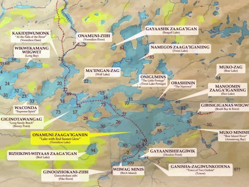
Bois Forte Band of Chippewa and Ely Folk School create a new map showing traditional names for more than 100 lakes, rivers…

Supporting the protection of the Minnesota-Ontario border region and Superior National Forest including the Boundary Waters Canoe Area Wilderness, Quetico Provincial Park, Voyageurs National Park, La Verendrye Provincial Park, Isle Royale National Park, and Lake Superior. Published by the Quetico Superior Foundation Since 1964. More About Us >
Follow us:


Help us preserve the wilderness character of canoe country for future generations.


Quetico Superior Wilderness News is published, in part, with a contribution from the Andrews-Hunt Fund of The Minneapolis Foundation.
CATEGORIES
TOP STORIES
  • 8 must-see waterfalls in the Boundary Waters Canoe Area Wilderness 5.1k views
  • Towboat regulations for BWCAW are back in court 2.1k views
  • Everything you need to know about the new BWCA food storage order 1.5k views
  • Conservancy aims to obtain 12,000 acres north of Two Harbors 1.1k views
  • Historic Boundary Waters legislation introduced in the U.S. Senate 1k views

INSTAGRAM

Instagram
All material © 2025 Quetico Superior Foundation | Web Site Privacy Policy & Terms of Use

Supporting the Protection of the Minnesota-Ontario border region and Superior National Forest including the Boundary Waters Canoe Area Wilderness, Quetico Provincial Park, Voyageurs National Park, La Verendrye Provincial Park, Isle Royale National Park, and Lake Superior. More About Us >