

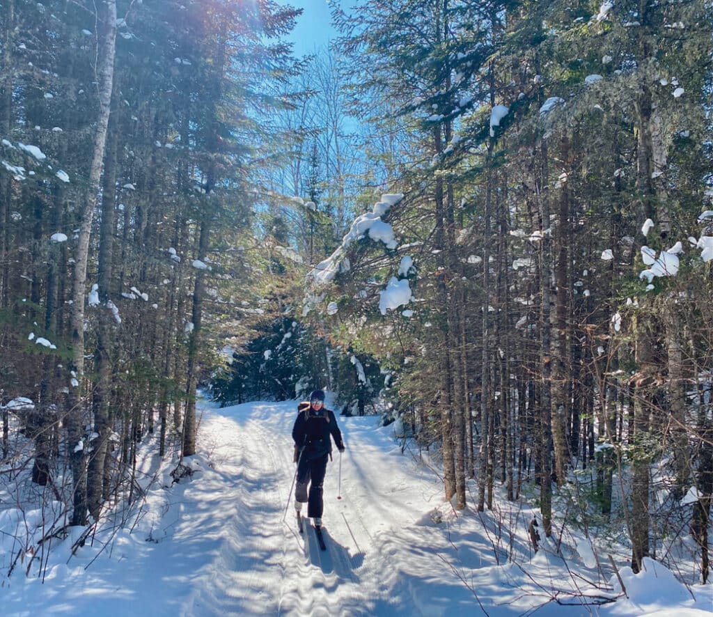
Our skis shushed through the woods, following two tracks that wound through a dense stand of pines. We were in the Boundary Waters Canoe Area, gliding down the Banadad Ski Trail in northern Minnesota. It is a unique experience to ski on one of the few groomed cross-country trails, largely located within a wilderness area.
We ventured deeper into the solitude. Snow weighed down the branches, highlighting the contrast in the mostly black and white world. Occasionally, white clumps fell, hitting us in the face. But we weren’t entirely alone. Tracks from moose, wolves, otters, and snowshoe hare told the story of the forest’s woodfolk. Prints seldom seen in warmer months appeared everywhere, crossing our path.
Experience it for yourself
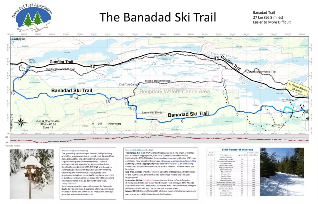
Located about 45 minutes northwest of Grand Marais, the ski trail loosely parallels the Gunflint Trail, a winding road that heads north toward Canada. It’s 27 kilometers (nearly 17 miles) in length, making it the longest groomed trail in the BWCAW.
The trail was developed from a network of old logging roads and overgrown paths. Logging in the region had mostly ceased by the 1960s, and protections for the area were strengthened under the Wilderness Act of 1964 and the Boundary Waters Act of 1978.
While these laws largely restricted motorized use, they included provisions allowing certain cross-country ski trails to be groomed by snowmobiles. By the early 1980s, two well-established ski trail systems, the Upper and Central Gunflint Trails, were in place. Local resorts collaborated with the U.S. Forest Service to create a connecting trail to the Gunflint systems. This was accomplished by going through a section of the BWCAW. Crews cleared overgrowth on the old roads and groomed the route with snowmobiles, establishing the Banadad as a cross-country ski trail in the early 1980s.
Since then, the public trail system has been maintained by the Banadad Trail Association, in cooperation with the USFS and the Minnesota Department of Natural Resources. Throughout the winter, the association’s volunteers help to maintain and groom the classic, single-track ski trail.
Interested in experiencing the Banadad for yourself? Use our helpful guide below to plan and prepare for your day on the trail.


Carry the essentials
When you go, bring a day pack filled with the essentials. Dress in layers so you can adjust as needed and avoid overheating. Don’t forget to let someone know your route and when you plan to return. Outfitters and experienced guides suggest bringing:
- Map, compass (more on those below)
- 1-2, 1-liter water bottles (wide mouth)
- 1-liter thermos filled with tea or hot cocoa
- Emergency blanket/shelter
- Signaling devices like a satellite communicator or whistle
- Fire starting kit
- Backpacking stove, fuel (optional)
- Metal mug or small pot to heat snow/water (optional)
- First aid and repair kit
- Headlamp
- Extra clothing, hat, gloves and mittens
- Snacks, extra food, electrolytes
- Small foam pad for sitting on (much warmer than sitting directly on the snow)
Practice good trail manners
You might not see many other skiers out there, but a little care goes a long way in keeping the trail a great experience for everyone. Trail manners tips:
- Yield to skiers going downhill as they have less control.
- Step completely off the trail when stopping or adjusting gear.
- Do not walk, snowshoe or skate ski in classic ski tracks.
- If you fall, get out of the tracks and smooth them over using one of your skis. This will help reset the track.
- Look both ways at intersections.
- Keep your noise level down. Everyone is seeking solitude and you’ll be more likely to see wildlife.
- Follow posted trail signs and respect closures.
- Be friendly. Let someone know if you’d like to pass them and pass on their left, if possible.


Good to know before you go
- You will need a BWCAW self-issued permit. It’s free and can be found at either trailhead in a box by the kiosk. Fill one out and keep it with you.
- A Minnesota Ski Pass is required. You can find it online with options for one or multiple days.
- Carry a reliable set of maps and consider bringing a compass. Download a free paper map of the trail. Also, download a digital map as backup.
- Parking is free at the eastern and western trailheads. There are no bathroom facilities. Plan to go off-trail and bury any waste. Pack out all garbage, toilet paper, and menstrual products.
- The trail is generally easy to moderate in difficulty, depending on how far you go. Difficulty will also depend on your skills and fitness level. Many sections are fairly flat or gently rolling. However, it passes over the Laurentian Divide in three separate locations. This means there are a few challenging hills along the route.
- Skiing from one end to the other may not be an option due to bridge damage and blowdown from the last season. Check with the Banadad Trail Association for the latest trail condition updates. In the meantime, plan for an out-and-back route.
The trail is remote enough to require preparation. Plan ahead and be ready for changing conditions. Outside access is difficult. Should you need to get off the trail, help or rescue may be hours away, and cell service is limited or nonexistent.
Looking to stay for more than a day? Choose from numerous lodging options along the Gunflint Trail. Cross-country skiing is one of the many great ways to experience this wild, winter wonderland.


More info:
- The Banadad Ski Trail
- Banadad Ski Trail – USFS-Superior National Forest
- Central Gunflint Ski Trail System
- Upper Gunflint Ski Trail System