

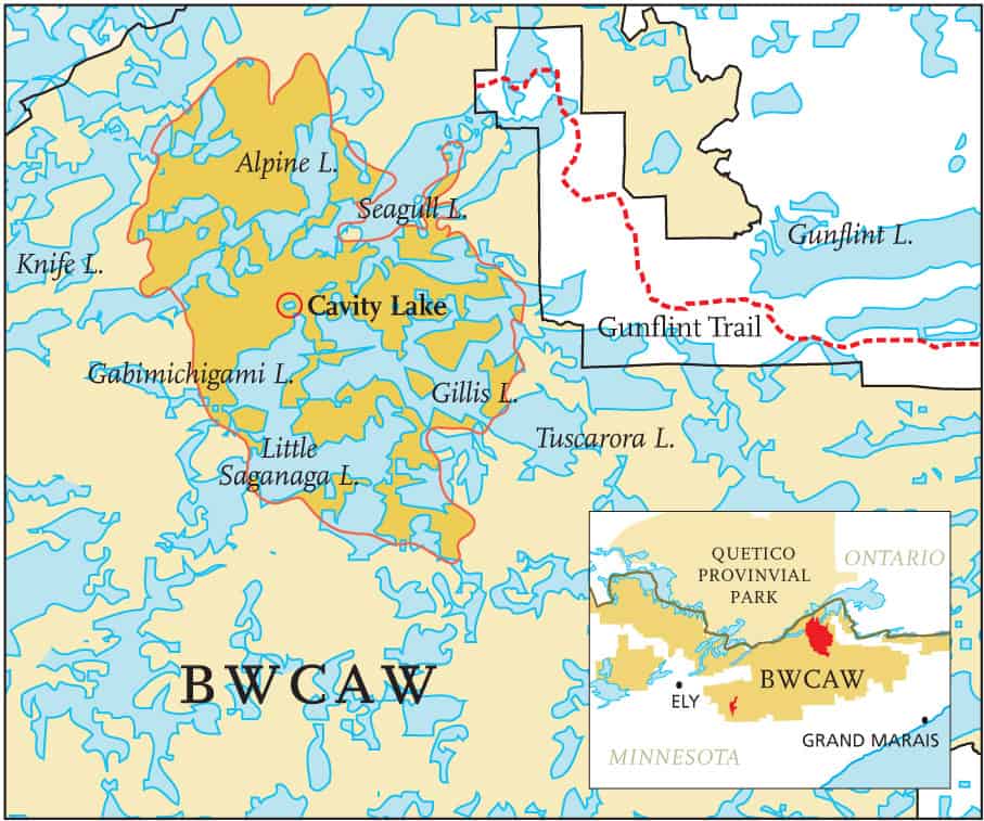
Over 31,800 acres have burned in the largest fire to hit the Boundary Waters Canoe Area region since 1894. A lightning strike near Cavity Lake on July 13th, started a wildfire which quickly grew to fifty square miles. The fire has burned an area of ‘blowdown’ from the 1999 wind storm representing about 8.5 percent of the total 367,000 acres of blowdown or 3 percent of the 1.1 million acres of BWCA Wilderness.
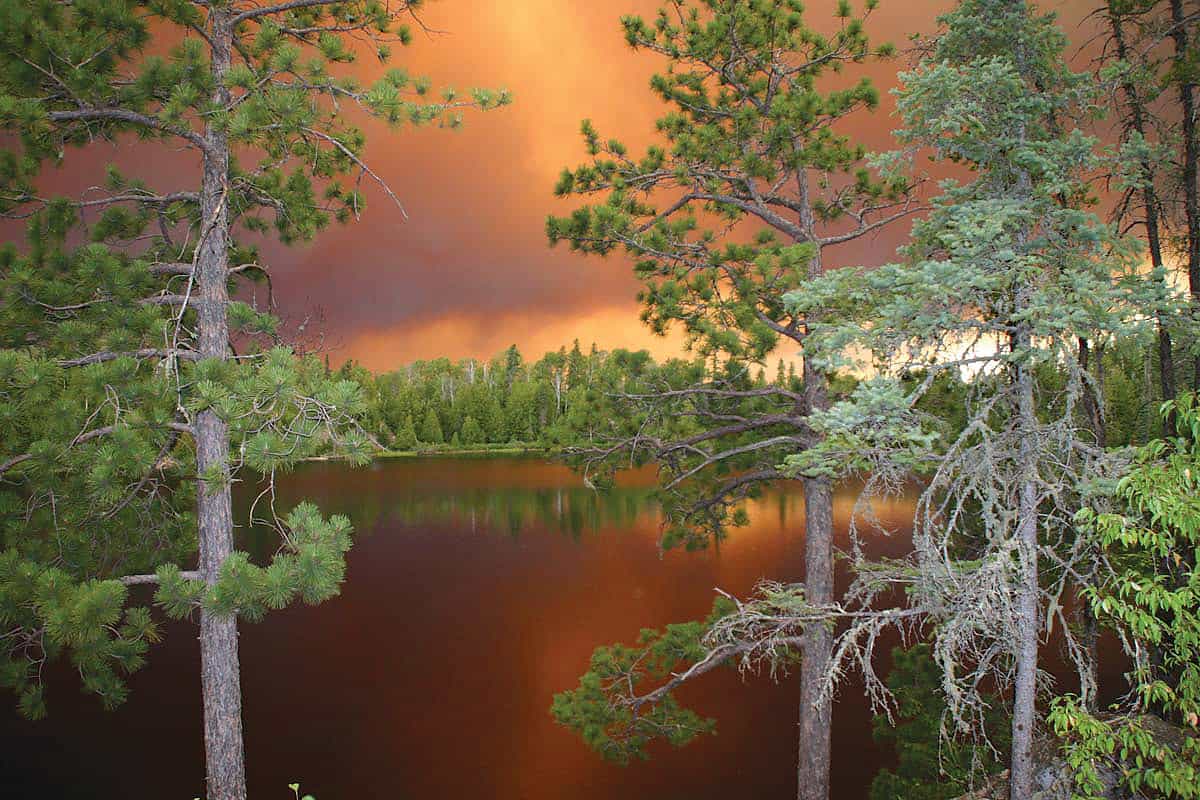
When the fire was spotted by a U.S. Forest Service plane on Friday July 14th it was reported to be burning in “heavy blowdown timber” and approximately 300 acres in size. On Saturday, the fire quadrupled in size to 1,300 acres and by Sunday afternoon had grown to 2,958 acres; more than four and one-half square miles. “It’s burning pretty intensely,” said Donna Hart from the U.S. Forest Service Gunflint Ranger District. But she didn’t yet know the fire would explode later that night, more than quadrupling again in size and sending balls of flames into the night sky—by daybreak Monday, the fire had expanded dramatically to 20 square miles; burning 11,200 acres of forest-land.
Burning erratically… According to Jim Sanders, supervisor of the Superior National Forest, which manages the BWCAW, the fire’s rapid growth and intensity was not a surprise. “The growth was all related to a (storm) downburst with 50-60 mph winds. The fire is behaving how our evaluation said the fire would behave back in November 1999, when we did our fuels assessment after the blowdown. It’s a good thing this fire happened when it did, instead of two years after the blowdown,” said Jim Sanders.
Too dangerous for fire crews on the ground… For the first four days, only planes were used in an attempt to control the fire. When fire crews hit the ground on Monday their focus was to protect the Gunflint Trail from an east-moving fire, and the Canadian border from a north-moving fire. The storm on Sunday night pushed fire in all directions. Fortunately, to the east, the fire bumped up against the 6,400 acre buffer zone created in 2003 by prescribed burns. This caused the fire to slow and lose intensity along that flank. Fire crews, now on the ground, tried to keep the fire burning westward and deeper into the wilderness. However, the fire pushed north to Seagull Lake, jumped to several of the lake’s islands and was within a mile of the Canadian border. This prompted the Canadian authorities to offer expertise, equipment and crews to start “control fires” in an attempt to rob the fire of fuel in key areas near the border.
Six days into the fire, 15,000 acres had burned in a 23 square mile area. The fire was burning to the south and slightly to the west. By day seven it had burned 19,800 acres in a 31 square mile area. On Thursday, July 20th, a week after it started, the fire had reached 44 square miles and had burned 28,500 acres.
Upgraded… Based on size, complexity and intensity, the wildfire’s severity category was upgraded on July 21st and a new national fire management team reserved for larger fires was called in to help. Total manpower leaped from about 250 to 500 by Sunday, July 23rd. Crews on the ground were supported by nine aircraft dropping water and fire retardant on the fire’s leading edge.
Nature helps out… On July 30th and 31st, thunderstorms dumped more than 1.5 inches of rain across the fire area; the fire was declared 80% contained. On August 1oth, a few weeks later, fire crews declared it 95% contained.
In total, the Cavity Lake fire burned 31,800 acres over a fifty square mile area. This area represents about 8.5 percent of the 367,000 acres of the 1999 blowdown or 3 percent of the total 1.1 million acre BWCA Wilderness.
Fires also burn in Quetico Park… Nine smaller fires have also been burning in Quetico Provincial Park. These fires across the Canadian border are believed to have been started by lightning strikes around the same time as the Cavity Lake fire. The largest of these fires has burned over 1,000 hectares. According to Quetico Park policy, officials were letting these fires burn. “We’ll put it out if it’s going to burn outside the park, but if it’s in the middle of the park, we mostly let them burn,” said Quetico Park Superintendent Robin Reilly. Seven of the nine fires are still active (burning). On August 1oth, the total area burned was reported to be 2,415 hectares, roughly 5,968 acres.
Elsewhere in the BWCA… Lightning stuck first in the BWCA on July 7th near Turtle Lake, about fourteen miles southeast of Ely. This fire was designated a Wildland Fire Use event by the Forest Service and allowed to burn under supervision by a fire management team from the Superior National Forest. The Turtle Lake fire burned 2,085 acres.
Fire and forest ecology… The research of the late Dr. Miron Heinselman and others clearly show that fire has played the most important role for thousands of years in regenerating the forests of the BWCAW and Quetico Provincial Parks. Comparison of dates from major fires in the BWCA Wilderness suggest that conditions favorable to intense burns, dense dry fuel, low precipitation, and high winds, occurred in 1727, 1759 and 1864. Heinselman’s research reports that a fire occurred somewhere in the BWCAW at least once every eighty years from about 1600 to present. He also found that the interval between burns in a given area was about eight years.
The Cavity Lake fire and 2006 will be undoubtedly be added to the historic list of intense fires and cycles of forest ecology in the BWCAW.
Allowing wildland fires to burn and play a role in the ecosystem will result in healthier and more sustainable forests in the Quetico Superior region for generations to come.
This article appeared in Wilderness News Summer 2006