


If you’ve paddled along the Minnesota–Canadian border in the Boundary Waters Canoe Area, one feature stands out—the seemingly endless forest and lakes to the north. Throughout the summer, paddlers frequently cross from Minnesota into Quetico Provincial Park. While the park is just over 100 years old, the landscape holds thousands of years of Indigenous history. When the government established Quetico in the early 20th century, it displaced Anishinaabe families and restricted their traditional land use. In recent decades, the Province of Ontario and Lac La Croix First Nation have worked toward reconciliation through formal agreements and collaborative park management.
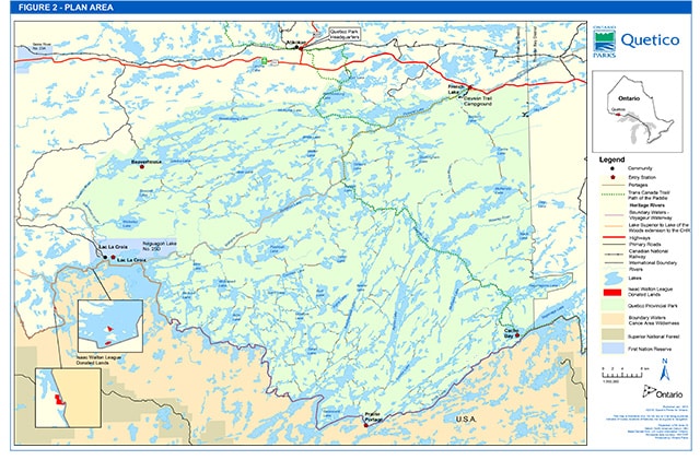
Unless you’re looking at a map, both sides along the Minnesota-Canadian border in the Boundary Waters Canoe Area Wilderness (BWCAW) appear almost identical. Thick boreal forests and the Canadian Shield shape the shorelines. Scenic islands dot the lakes and bays. Occasionally, you might spot a campsite. Aside from a couple of ranger stations and a few other markers, nothing clearly signals that Quetico Provincial Park (Quetico) lies to the north. In some places, you can stand in the U.S and Canada at the same time.
Complex history
While the land has changed little, Quetico has a complex history. Most people think of it as a paddler’s paradise with over 1 million acres to explore. But the land has played an important role in the lives of the Anishinabeg people for thousands of years, as they lived, hunted, and travelled in the region, and continue to do so.
When Europeans entered the picture, fur traders and voyageurs began using the border waterways to transport goods between the interior and the shores of the Great Lakes during the 17th and 18th centuries. These rivers and lakes formed an important trade route connecting Indigenous communities, European settlements, forts, and trading posts.
The name Quetico comes from the Ojibwe word “Gwetaming”. In the park management plan, the Lac La Croix First Nation leaders highlighted the region’s importance. They stated that, “This refers to how we view this sacred land. There is a place in the park that is named Quetico Lake. The lake is sacred, meaning it is occupied by living spirits that have been here since time immemorial. You hear stories from our elders of unexplained and unusual events at this lake, which can only be explained by our spiritual ways. The Lake is very spiritual and sacred to us. We are told to be mindful and respectful of the power it holds. “Gwetaming” means we sacredly respect that area for the spirits that dwell there.”
Today, pictographs and other artifacts throughout the park still remind visitors of that history. If you are lucky to see some, please honor the community by leaving them as is.
Designated wilderness
Following treaty signings in Ontario, the federal government established reserve lands for the First Nations people. Over time, the government increasingly confined those native communities to these reserves under its Indian policy. Some were near or within the bounds of what is now Quetico.
Until the late 1800s, the Sturgeon Lake Indian Reserve 24C was on the eastern edge of Quetico. People lived there until 1915, when authorities dissolved the reserve and relocated the residents, resulting in their loss of land.
Then, amid a growing conservation movement in North America, concerns increased about protecting the region’s forests and waterways. As a result, Quetico was first designated a forest reserve in 1909. In 1913, it became a provincial park under Ontario’s Provincial Parks Act, which set aside land deemed “not suitable for agriculture or settlement.” Approximately 1,180,000 acres were preserved, primarily for recreational and conservation purposes. The area also became known as the Quetico–Superior region.
As settlement and development expanded, the timber industry grew. Loggers extensively harvested red and white pine in Quetico during the late 19th and early 20th centuries. Large-scale logging declined by the mid-20th century and ended completely when officials designated Quetico a wilderness park in 1971.
After the Province established the park, it created additional challenges for the Lac La Croix. They no longer had access to many of the traditional ways that sustained them. As a result, the community faced serious difficulties, and its economy weakened.
Injustices continued until 1991, when the Minister of Natural Resources issued a formal apology for actions that had negatively impacted Lac La Croix. Park authorities made changes that not only acknowledged the Nation’s traditional homeland but also revised the park’s management plan to benefit them and restore some of the activities lost.
In 1994, the Agreement of Co-existence further strengthened the relationship between the First Nations and the Province. Since then, the Lac La Croix First Nation has co-managed a large portion of the park alongside the Government of Ontario. Activities such as motorized guiding and fishing are now permitted on certain lakes. In addition, the Nation continues to exercise legal rights that have long supported its communities.
Wilder, more remote
While Quetico shares some similarities with the BWCAW, there are some significant differences. About 26,300 people visit the park each year, compared to the 150,000 who visit the BWCAW. According to a 2011 survey, 83% of park visitors were from the United States, with many of those entering from the southern boundary. In keeping with wilderness characteristics, visitors are allowed to camp anywhere, though guidelines recommend people choose one of 2,000 established campsites. There is less infrastructure in the park as well. While campsites may have a fire ring, they do not have a latrine or picnic table. Because of this, the park feels truly wild, and you’re not likely to see many others.
The Quetico-Superior region is one of the largest wilderness areas in North America, attracting thousands of paddlers to its pristine lakes each year. Since the establishment of Quetico, the governments of both countries have worked together to support and protect these interconnected wilderness areas while enhancing visitor experiences.
More info:
- First Nations in Canada – Government of Canada
- Quetico Provincial Park Management Plan – Ontario
- Why Quetico? – Quetico Foundation