


Each spring, the Forest Service plans prescribed burns throughout the Superior National Forest. The work is expected to begin this month and, depending on conditions, will go through June. This is done annually to safeguard communities from wildfires and reduce fuel loads.
Prescribed burns help manage forest health
Beginning in April, the USFS-Superior National Forest (USFS) plans to conduct prescribed burns across certain areas of its nearly 4 million acres. This work is done annually to help protect nearby communities and other infrastructure from wildfires. Work also includes reducing excessive vegetation that could contribute to heavy fuel loads.
According to the Superior National Forest release, “Prescribed fires originate from a planned ignition in accordance with applicable laws, policies and regulations to meet specific objectives to reduce overgrown vegetation and help protect local communities, infrastructure and natural resources from wildfires.”
Before the work begins, specialists develop plans in accordance with national standards. During this time, survey teams also identify cultural and natural resources that may need protection. Planners also consider threatened or endangered wildlife. As a result, they may clear areas near critical habitat, such as Eagle nesting sites, and install sprinklers to protect them.
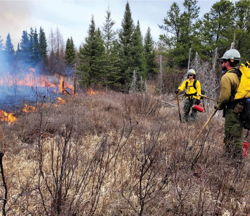
How burns are managed
Once approval is given, preparations begin on the ground. Crews establish and clear control lines, which are spaces that prevent fire from spreading beyond the intended areas. Work may also include planning helicopter landing sites and coordinating backup crews and other needed equipment.
Then, depending on the weather and wind conditions, crews ignite ground fires with drip torches. Managers may also use aircraft to help ignite the burns. Once the fire is lit, it is closely monitored. Crews set up water hoses and staged aircraft to use water to safely manage the fire. If conditions become unfavorable, officials will cancel the burn. According to the forest service website, there is only a small window (about 10-20 days) where conditions are safe enough to conduct a controlled burn.
Wildfires have long been a part of the landscape, and many ecosystems are fire-dependent. Certain species, such as jack pine cones, need fire to open and release their seeds to reproduce. Low-intensity burns also help to eliminate brush and dead, diseased trees, reducing the risk of larger, uncontrollable fires. A post-fire landscape stimulates new growth, attracting animals and plants that thrive in open habitats.


Locations of prescribed burns
Crews will conduct prescribed burns in nearly 20 locations throughout the forest. According to the Duluth News Tribune, about 5,500 acres will be cleared by fire.
The USFS provides regular updates about the prescribed burns on its website, Facebook, and X (formerly Twitter). There is also an option to sign up for email notices. County emergency management officials will also be alerted when work begins.
Prescribed fires planned for Gunflint and Tofte Districts (east side)
- Fiddle Creek (695 acres) is located approximately 13 miles up the Gunflint Trail and five miles west of the South Brule Road in Cook County.
- Hungry (81 acres) is located approximately one mile northwest of the Devils Track Campground and boat access off Cook County Road 8-Devils Track Road.
- Sunfish Lake (775 acres) is located south of Greenwood Lake off the Gunflint Trail. This unit is combined Forest Service and Minnesota Department of Natural Resources-managed land.
- Kawishiwi Lakes (1,911 acres) is in the Kawishiwi Lakes Roadless Area, approximately 18 miles north of Tofte at the intersection of the Sawbill Trail and the Perent Lake Road.
- Shack Units and Elixir (142 acres) are approximately eight miles northeast of Isabella, along the Wanless Road.
- Tail (456 acres) is located approximately 15 miles up the Sawbill Trail north of Tofte.
- Tanner (226 acres) is located approximately six miles east of Isabella, off Forest Road 172 and Forest Road 174 in Lake County.
Prescribed fires planned for the Kawishiwi, LaCroix, and Laurentian Districts (west side)
- Integrator (139 acres) is located near the junction of County Road 65 and MN State Highway 73, west of Lake Leander, approximately 14 miles northwest of Virginia, MN.
- Fourteen (87 acres) is located south of Lake Leander, Lake Fourteen, and County Road 65, approximately 10 miles northwest of Virginia, MN.
- Jack Pine Bay (48 acres) is located on the south side of MN State Highway 1, approximately 10 miles southeast of Cook, MN.
- Murphy Lake (80 acres) is located near the Toimi area, 2 miles south of Murphy Lake and 4 miles east of Brimson, MN.
- Norwegian Island (9 acres) is located on the west end of Norwegian Bay of Lake Vermilion, north of Cook, MN.
- Lisa and Rangeline Creek (226 acres) are located along County Road 116 (Echo Trail) east of Lake Jeanette, approximately 24 miles northeast of Orr, MN.
- Big Bull (29 acres) is located south of County Road 116 (Echo Trail) along the Moose Loop South Forest Road 464, approximately 28 miles northeast of Orr, MN
- Geraldine (285 acres) is located 0.5 miles west of the North Arm Road, east of Geraldine Lake, approximately 7 miles northeast of Ely, MN.
- Fenske (136 acres) is located along County Road 116 (Echo Trail), approximately 6 miles north of Ely, MN.
- Deer Ridge (37 acres) is located off Mushroom Island Road and White Iron Lake, approximately 2.5 miles southeast of Ely, MN.
- Bear Island (121 acres) is located on Bear Island Lake, approximately 10 miles south of Ely, MN, and 1 mile east of St. Louis County Highway 21.
People should be aware that there may be closures in certain areas for multiple days. To keep everyone informed, crews will post signs along inaccessible roads where the burn is taking place. Depending on conditions, there may be areas of thick smoke that will not only impact visibility but also air quality. More information on air quality can be found at AirNow.
Officials expect the prescribed burns to continue through June. For updates on local and nationwide wildfires, visit InciWeb, which provides up-to-date maps and incident information.

More info:
- Superior National Forest to begin prescribed fires – USFS-Superior National Forest
- Prescribed Fire – USFS-Superior National Forest