
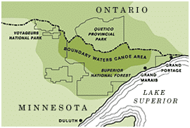
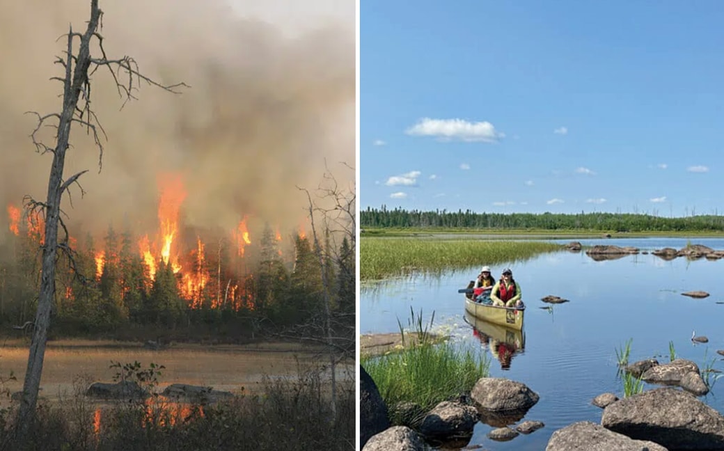
I turned our canoe into the Isabella River on a hot, windy morning, days after this stretch of the Boundary Waters reopened to visitors. It was quiet — a soft breeze, a few white-throated sparrows near the edge of a bog. Fifteen years ago this was the heart of the Pagami Creek Fire, one of the largest in Minnesota history. With fires burning across the wilderness again this summer, I came to see what a burned landscape becomes.
One of the largest fires in the last 100 years
Fifteen years ago, in August 2011, a storm rolled through Lake One, about 20 miles east of Ely. Like many summer storms, it likely began as cumulonimbus clouds that built through the early afternoon, their dark gray bellies filling with rain. As the storm broke, lightning struck somewhere near Pagami Creek, just south of the lake. There, in a quiet bog, a fire smoldered and grew until, on the 18th, it was detected and reported by USFS-Superior Forest personnel. According to an article in the Timberjay, fire managers decided to “keep it within a reasonable maximum management area while allowing natural processes to do their thing, rather than try to suppress it.” By August 26, it was burning over 130 acres. However, the driest autumn in 140 years was approaching, and, along with other weather changes, it created the perfect conditions for a historic wildfire not seen in decades.
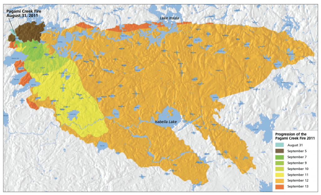
By mid-September, those dry conditions would stir the flames, causing them to leap from tree crown to tree crown. Forest Rangers paddled into area lakes, warning canoe campers and advising them to leave. Due to high winds, the fire began spreading rapidly, in some cases over 10 miles in a day.

By September 13, the wildfire had grown to roughly 93,000 acres, making it the fifth-largest fire in Minnesota history—and the largest the state had seen in nearly a century. Seventy days later, crews had fully suppressed the fire. Managing it cost around $20 million.
Thankfully, there were no fatalities, and the Forest Service came away with important lessons about firefighter and public safety. One of the biggest takeaways seemed to be more aggressive area closures. Early on, officials believed they would only need to close a few lakes at a time, hoping to balance public access with safety. That approach proved dangerous. As the fire intensified, several wildland firefighters were forced to deploy their fire shelters, and about 100 campers had to be quickly evacuated.


Life after fire
I pondered the history of the wildfire as I paddled east on the Isabella River toward Isabella Lake. Much like the summer of 2011, it has been hot, windy, and dry. We are among the first groups in the area after a two-week closure due to ongoing wildfires in the wilderness. Some of them are large too. In total, around 68,000 acres have burned in the Boundary Waters Canoe Area Wilderness (BWCAW) this summer. Fire managers expect some of them to burn until winter snows arrive. Crews are still in the field, managing the fires while protecting visitors and nearby communities.
One of the things most noticeable to me after a fire is the topography. Rocks, cliffs, ledges, and hills become more evident. Large stretches of dark gray gabbro and other igneous rock that form parts of the Canadian Shield emerge from the landscape. It feels raw and exposed. There are also occasional large glacial erratics. The river is low, revealing basalt and granite stones along the surface. Once in a while, we unload and lift the canoe over a short distance before picking our way through the rock gardens again.


As we follow the stream, it almost seems as though we are much further north in Canada, where the treeline ends and the tundra begins. The edges are thick with willow and alder. Above them, the forest is filled with young aspen and birch. These are some of the first trees to push through the soil after a fire. Young, healthy-looking Jack Pine, a tree whose seeds need fire to open and spread, are growing here and there. Ashen-colored remnants of fire-impacted aspen stand tall above the new growth. Their crowns burned during the Pagami Creek fire. Many still had fire scars. Here and there, bright purple patches of fireweed tucked themselves between the grasses and bushes.


We found a campsite on the eastern side of Isabella, near the water outflows into the Perent River. We spent part of our time hiking along the low and very exposed shorelines. One morning, I packed a lunch, and we headed east, exploring about 3 miles of the river system. There was no one around except us, and most of the portages seem little-used and overgrown. Lots of scratchy raspberry bushes choke our path, but we’re rewarded with ripe berries.
One afternoon, as I walked along the shoreline and scrambled over exposed rocks, I noticed bits of silvery wood and fire-scarred trees. I peeked into trees that had become chimneys of fire, their outsides mostly untouched, but their insides totally charred and hollow. Even inside those darkest places, life was returning. Delicate pockets of moss held all kinds of lichen and tiny plants. A patch of bright red lichen, called British Soldiers, contrasted against the dark decay. A tiny northern white cedar clung to the edges of a burned-out log. Signs of recovery were everywhere.

A landscape remembered
Notably, the 2011 fire had not eradicated everything. I was reminded that while fire can have a significant impact, not everything burns. Occasionally, we saw tall white and red pines, as well as aspen and birch that the fire had missed. There were still “islands” of mature forest.
The last time I was in the Isabella region was a few years before the Pagami Creek fire. Our family took a canoe trip west along the river towards Gabbro Lake. I recall paddling alongside thick woods filled with tall trees. Portages were around picturesque cascades when the water was much higher.
I have been making trips “up north” for nearly 30 years. For the past five years, I’ve spent the entire season in the woods, working as a guide. I’ve had the privilege of observing an ever-evolving landscape. While changes don’t happen quickly, we feel them most when a wildfire comes through. This summer is no different. Everyone is feeling the effects of wildfires in a landscape shaped by fire. Familiar scenery in places we return to again and again may now be unrecognizable. Portages and campsites have been impacted, some even obliterated. I wonder about my favorite old-growth pines along a remote portage trail. Did they burn too? I’m not sure when I’ll be back in that area again. When fire moves through, we often change our routes and seek out other areas to explore.
I wondered how I’d feel about returning to the Isabella region, a place I had experienced “in its prime.” Would I mourn what had been lost? Would it feel like a lonely landscape, overshadowed by the more iconic northern wilderness I love?


The re-wilding
Isabella definitely looked different and unfamiliar, but what stuck out to me was the impressive growth. Shortly after we left the entry point, we paddled through thick areas of wild rice, sometimes surprising a clutch of merganser ducks.
In a small bay near Isabella Lake, a pair of eagles had built a nest in an old snag. It stood strong, but exposed above the dense growth below. We watched as they wandered around the lake each day, keenly observing, seeking fish or other prey.
A family of beavers swam by our campsite every evening. We spent hours watching them. They would perch on a slab of rock, chewing aspen and filling their almost-winter-ready bodies. They would murmur to each other, change positions, and eventually swim off to some unknown destination, probably their lodge.
A Belted Kingfisher flitted past the edges of a creek behind camp where we wandered to sit and read. Their strident chatter warned others of our presence. The path to the latrine was filled with ferns, sphagnum moss, and Bluebead lilies. Bright red bunchberries blanketed the forest floor near my tent.
As I sat one evening, watching another stunning pastel-washed sunset, my eyes scanned around the lake. The western and northern edges were most impacted by wildfire. Stubby trunks stood out against the low hills where the fire had the most impact to the west and north. To the south and east, there were more intact swaths of forest. Most of the islands on the lake were spared, with tall pines holding tightly to the rocky lumps of land.
Evidence of the boreal forest remains. The aspen and birch will reach maturity in another 15 years. However, the young pines will take much longer to mature, with Jack Pine showing especially strong growth. Here, more than in many other places in the wilderness, the landscape feels especially alive with change.
The wilderness has a remarkable capacity for renewal. Even the fires that are burning now will bring new life. Dormant seeds will sprout, young saplings will grow, and the animals will find their way back, building lodges, burrows, and nests. It won’t be the same, but it will be beautiful again.

More info:
- Pagami Creek Fire – USFS-Superior National Forest
- Pagami Creek Fire: An overview – The Timberjay
- Survivors reflect on the day the Pagami Creek Fire exploded 10 years ago – MPR News
- Pagami Wildfire – WildlandFireLLC
Wilderness guide and outdoorswoman Pam Wright has been exploring wild places since her youth. Remaining curious, she has navigated remote lakes in Canada by canoe, backpacked some of the highest mountains in the Sierra Nevada, and completed a thru-hike of the Superior Hiking Trail. Her professional roles include working as a wilderness guide in northern Minnesota and providing online education for outdoor enthusiasts.