

New post-wildfire Forest Closure Order reopens four entry points, closes three others
With the July Lightning Incident fires fully contained, the Forest Service has issued a new forest closure order (09-09-00-26-11), replacing the phased wildfire-reopening orders we’d been tracking, effective October 1.
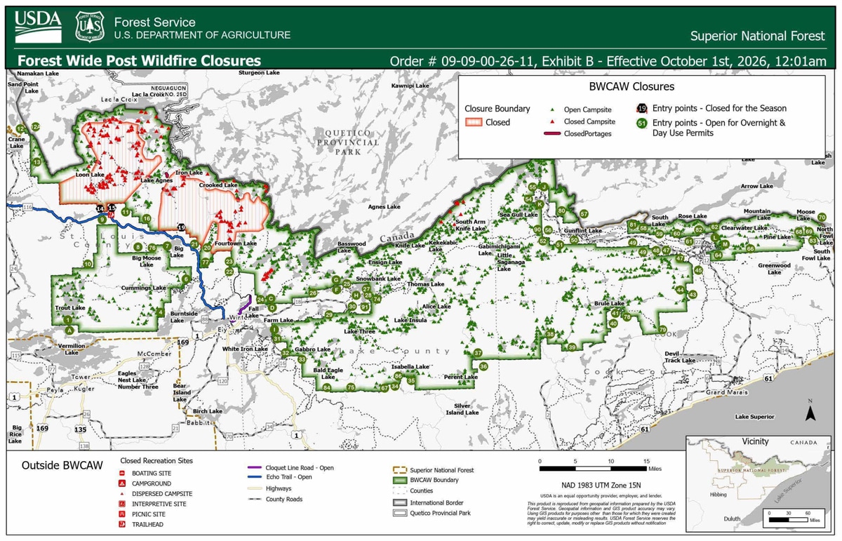
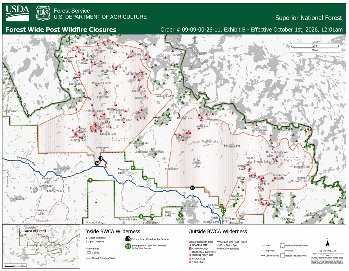
It reopens four BWCAW entry points for day and overnight use: #11 (Blandin Trail), #16 (Moose/Portage River North), #20 (Angleworm Lake), and #21 (Angleworm Trail) — though travel north of the Home-Gull Portage on the Angleworm Trail entry points remains off-limits. The North Hegman and Angleworm portages have also reopened, and the agency says there are no fire-affected sites remaining on Ramshead, Nina Moose, or Agnes lakes. Additional campsites have opened around South Arm Knife Lake and Lake Agnes.
Three entry points are closed through Spring 2027 for continued maintenance and rehabilitation: #14 (Little Indian Sioux River North), #15 (Sioux-Hustler Trail), and #19 (Stuart River), along with their parking lots. The portages from Agnes to Oyster River and from Boulder River to Dahlgren River are also closed. National Forest System land along the northern Echo Trail remains closed, and some BWCAW campsites affected by the wildfires remain closed as shown on the forest’s Exhibit B map. Visitors should continue watching for wildfire hazards — fire-weakened trees and burnt stump holes — and plan extra time to find a campsite in affected areas. Find more information on the Forest Service’s Alerts page.
September 2 update:
Phase 10 reopens six entry points for day and overnight use September 8
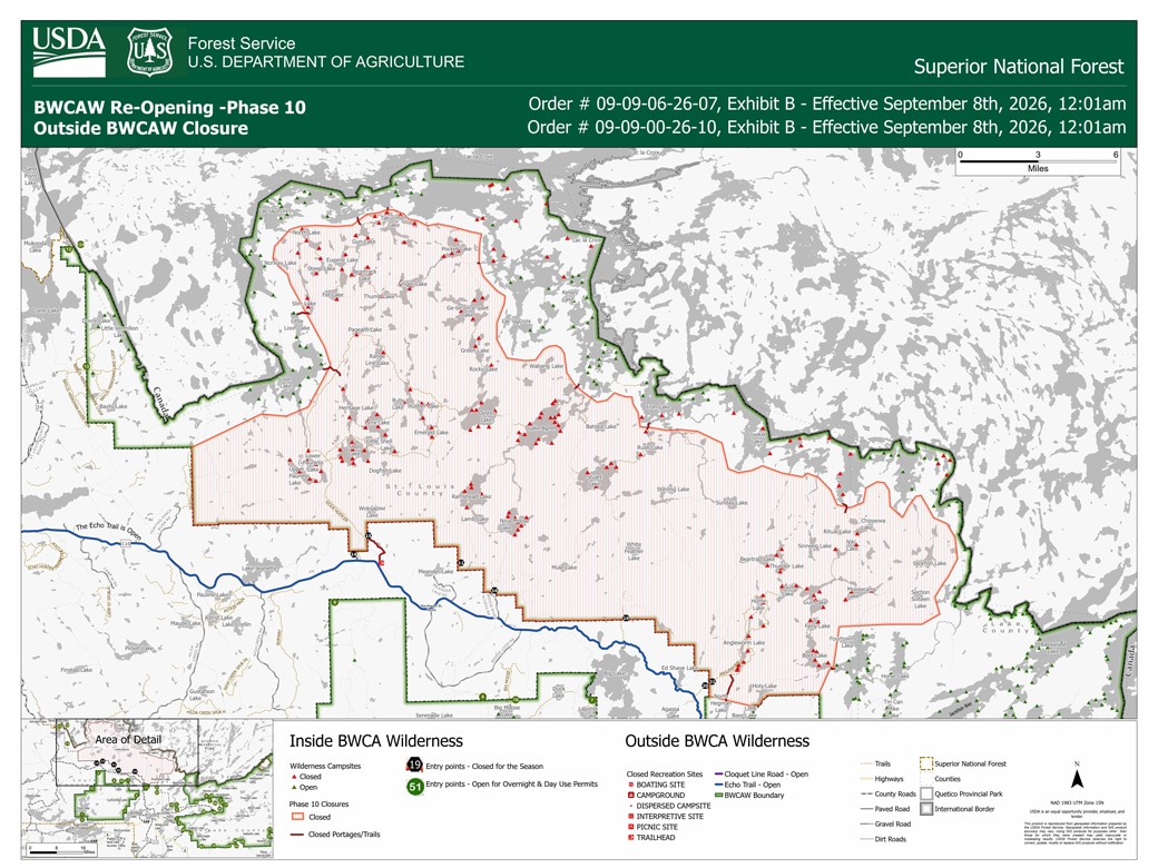
Phase 10, effective September 8, reopens six BWCAW entry points for both day and overnight use: #12 (Little Vermilion Lake), #12A (Lac La Croix Only), and #13 (Herriman Lake Trail) on the LaCroix Ranger District, and #22 (Mudro Lake Restricted), #23 (Mudro Lake), and #24 (Fall Lake) on the Kawishiwi Ranger District. Three recreation areas along the Echo Trail also reopen: Ed Shave Road and boat launch, Meander Lake picnic area, fishing pier, and backcountry sites, and the Fire and Ice Interpretive Trail.
Seven entry points are now closed for the rest of the season: #11 (Blandin Trail), #14 (Little Indian Sioux River North), #15 (Sioux-Hustler Trail), #16 (Moose/Portage River North), #19 (Stuart River), #20 (Angleworm Lake), and #21 (Angleworm Trail) — the latter two newly added to the season-closed list; they’d only been cancelled through September 7 under Phase 9. National Forest System land along the northern Echo Trail remains closed, with continued travel delays expected there. The agency is reminding visitors entering newly reopened areas to watch for fire-weakened hazard trees and burnt stump holes, and to plan extra time since some campsites and portages nearby remain closed.
August 26 update:
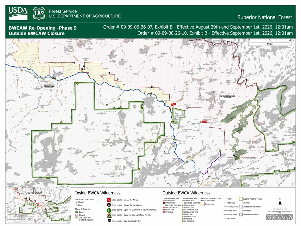
Phase 9 reopens Fall Lake and Little Vermilion for day use
The Forest Service says more than 1,600 BWCAW campsites and 2,930,000 of the forest’s 3 million total acres are now open. Under Phase 9, Entry Point D (Fall Lake-Newton-Pipestone Bay, “Fall Lake and Beyond”) reopens for day use August 29, and Entry Point #12 (Little Vermilion Lake) reopens for day use only September 1. Lake Jeanette Campground, its boat launch, and backcountry sites, along with the Nels Lake boat launch and backcountry sites, also reopen September 1.
Nine entry points are cancelled through September 7: #12 and #12A (overnight paddle and motor use), #13, #20, #21, #22, #23, #24 (overnight paddle and motor use), and #71. Cancelled through the end of the permit season, September 30: #11 (Blandin Trail), #14 (Little Indian Sioux River North), #15 (Sioux-Hustler Trail), #16 (Moose/Portage River North), and #19 (Stuart River).
August 19 update:
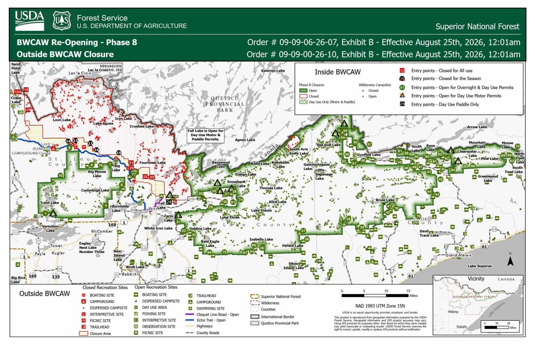
Phase 8 reopens Entry Point #9 and South Hegman Lake August 25
Entry Point #9 (Little Indian Sioux River South) is now set to reopen August 25 under Phase 8, along with Entry Point #77 (South Hegman Lake, Kawishiwi Ranger District). The agency says over 1,600 campsites remain open across the BWCAW.
Nine entry points are cancelled through August 31: #12 (Little Vermillion Lake), #12A (Lac LaCroix Only), #13 (Herriman Trail), #20 (Angleworm Lake), #21 (Angleworm Trail), #22 (Mudro Lake Restricted), #23 (Mudro Lake), #24 (Fall Lake — closed to overnight use, open to day use), #71 (From Canada), and D (Fall Lake and Beyond). Five entry points are cancelled through the end of the quota permit season, September 30, for wildfire-related maintenance and rehabilitation: #11 (Blandin Trail), #14 (Little Indian Sioux River North), #15 (Sioux-Hustler Trail), and #16 (Moose/Portage River North) and #19 (Stuart River).
National Forest System land along the northern Echo Trail remains closed, though the Echo Trail itself stays open with continued delays expected from wildfire operations along the corridor.
August 11 update:
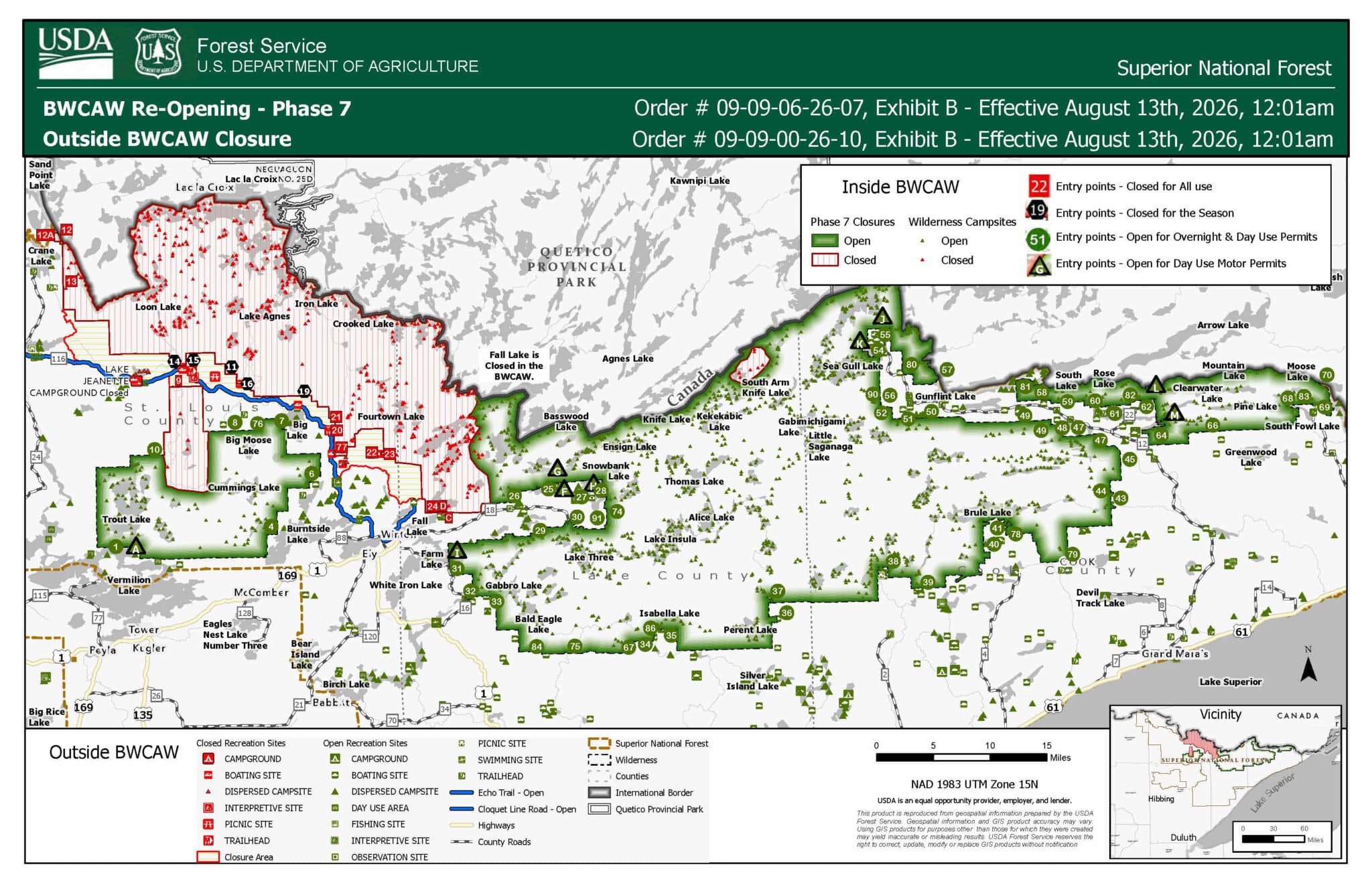
Entry Point update; Little Knife boundary reduction opens 40 campsites
The Forest Service says more than 1,600 campsites are now open across the BWCAW, boosted by a reduction in the Little Knife Fire’s closure area that opened 40 additional campsites. The agency reminds visitors not to camp on any site still marked “closed” within or near that footprint, warning that portages, campsites, and latrines inside the former fire perimeter may have snag trees at risk of falling.
Two entry point changes revise what we reported August 8 for Phase 7: Entry Point #9 (Little Indian Sioux River South), previously set to reopen August 13, is now cancelled through August 17 instead. Entry Point #16 (Moose/Portage River North) — already cancelled through August 17 under Phase 6 — is now cancelled for the rest of the quota permit season. Separately, National Forest System land along the northern Echo Trail and between Cloquet Line Road and the wilderness boundary remains closed, though the Echo Trail itself and Cloquet Line Road are open to travel; the agency cautions that wildfire operations continue along the Echo Trail corridor.
August 8 update:
Phase 7 reopens over 1,500 campsites August 13
The Forest Service says Phase 7, effective August 13, will bring the total to more than 1,500 of the BWCAW’s 2,000+ campsites reopened. Five entry points open around Big Moose and Big Lake: entry point 7 (From Big Lake) on the Kawishiwi District, and entry points 8 (Moose River South), 9 (Little Indian Sioux River South), 10 (Norway Trail), and 76 (Big Moose Trail) on the LaCroix District. Permit cancellations for entry point C (Fall Lake Only, motor use) and the Lake Jeanette Campground are extended to August 17.
Fire restrictions remain in effect forest-wide — campfires are restricted to designated fire rings in developed and rustic campgrounds and remain prohibited in the BWCAW. The agency again cautioned that some reopened and still-closed areas remain affected by suppression efforts and continued activity from the Camp, Bear Trap, Sioux, and Thumb fires, and that the reopening plan could change if wildfire activity increases.
August 6 update:
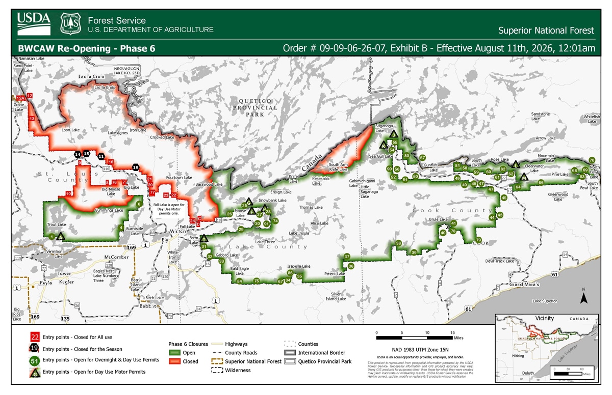
Phase 6 opens Kekekabic and Pow Wow Trail entry points on August 11
The Forest Service says it has now opened over 70% of the one-million-acre BWCAW. Phase 6, effective August 11, reopens five entry points: Kekekabic Trail-East (56), Kekekabic Trail West/Snowbank (74), North Country Trail East (90), North Country Trail West (91), and Pow Wow Trail (86). Permit cancellations for the remaining entry points are extended: six entry points (C, 7, 8, 9, 10, and 76) through August 12, and eleven entry points (D, 24, 23, 22, 21, 20, 16, 13, 12, 12A, and 77) through August 17, citing active fire suppression response and work in those areas.
The Forest Closure Order remains in place outside the BWCAW for the Echo Trail between North Arm Road and FR 200, and the Lake Jeanette Campground closure and associated permit cancellations are extended through August 12. The agency says some reopened and still-closed areas remain affected by suppression efforts and continued activity from the Camp, Bear Trap, Sioux, and Thumb fires, and cautions that the reopening plan could change if wildfire activity increases.
August 2 update:
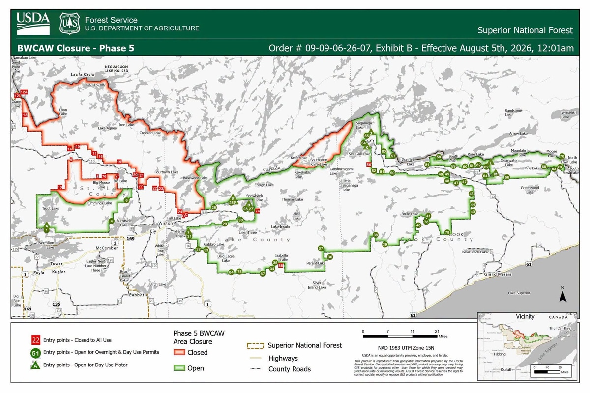
Phase 5 reopening set for August 5
Additional overnight entry points on the Kawishiwi and LaCroix Ranger Districts — including the Trout Lake Unit and entry points off the Fernberg Road — reopen Wednesday, August 5. Permits for entry points not listed in the agency’s Exhibit A or B are now cancelled through August 10 (extended from August 4). A fourth entry point, Blandin Trail, joins Little Indian Sioux River North, Sioux-Hustler Trail, and Stuart River on the list cancelled for the rest of the permit season, through September 30, for wildfire-damage rehabilitation.
Kawishiwi Ranger District — open for overnight use August 5:
- 6 Slim Lake
- 25 Moose Lake (no paddle travel beyond Lewis Narrows and Upper Basswood Falls)
- 26 Wood Lake
- 27 Snowbank Lake
- 28 Snowbank Lake only
- 29 North Kawishiwi River
- 30 Lake One
- 31 Farm Lake
- 32 South Kawishiwi River
(33 Little Gabbro Lake has been open for overnight use since July 30.)
LaCroix Ranger District — open for overnight use August 5:
- 1 Trout Lake
- 4 Crab Lake and Cummings Lake
August 1 update:
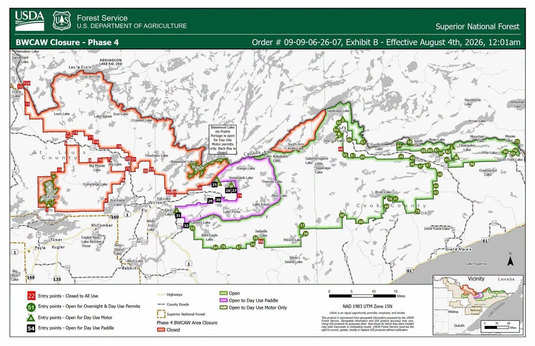
Phase 4 reopening set for August 4
The Forest Service announced that the entire Gunflint Ranger District entry point list below will open for overnight use — an expanded roster that adds Seagull, Saganaga, and Magnetic lakes and the Larch Creek entry points. Permits for areas still affected by the Bear Trap, Sioux, and Thumb fires remain cancelled through August 4. Three entry points directly damaged by the fires — Little Indian Sioux River North, Sioux-Hustler Trail, and Stuart River — are cancelled for the rest of the permit season, through September 30, pending trail and campsite rehabilitation.
Gunflint Ranger District — open for overnight use August 4:
- 43 Bower Trout Lake
- 44 Ram Lake
- 45 Morgan Lake
- 47 Lizz and Swamp Lakes
- 48 Meeds Lake
- 49 Skipper and Portage Lakes
- 50 Cross River
- 51 Missing Link Lake
- 52 Brant Lake
- 54 Seagull Lake
- 55 Saganaga Lake
- 57 Magnetic Lake
- 58 South Lake
- 59 Partridge/South Lake Trail
- 60 Duncan Lake
- 61 Daniels Lake
- 62 Clearwater Lake
- 64 East Bearskin Lake
- 66 Crocodile River
- 68 Pine Lake
- 69 Little John Lake
- 70 North Fowl Lake
- 78 Brule Lake Trail
- 79 Eagle Mountain Trail
- 80 Larch Creek
- 81, 82, 83 Border Route Trail (west, center, east)
- J Saganaga Lake (day-use motor)
- K Sea Gull Lake (day-use motor)
- L Clearwater Lake (day-use motor)
- M East Bearskin Lake (day-use motor)
Kawishiwi Ranger District — open for day use only, effective July 31 (Phase 3):
- 25 Moose Lake (no travel over or beyond Prairie Portage)
- 27 Snowbank Lake
- 28 Snowbank Lake only
- 29 North Kawishiwi River
- 30 Lake One
- 31 Farm Lake
- 32 South Kawishiwi River
- F Moose, Newfound, Sucker (day-use motor)
- G Moose, Prairie Portage and Beyond (day-use motor; no travel to Back Bay)
- H Snowbank Lake (day-use motor)
- I South Farm Lake (day-use motor)
Tofte Ranger District and Kawishiwi’s Little Gabbro Lake (33) remain open for overnight use as they have been since Phase 2. All other entry points on the LaCroix Ranger District stay closed within the BWCAW.
Phase 3, effective July 31, added day-use-only access at several Kawishiwi Ranger District entry points, including Moose, Snowbank, and Farm lakes.
Read the official release here.
July 27 update:
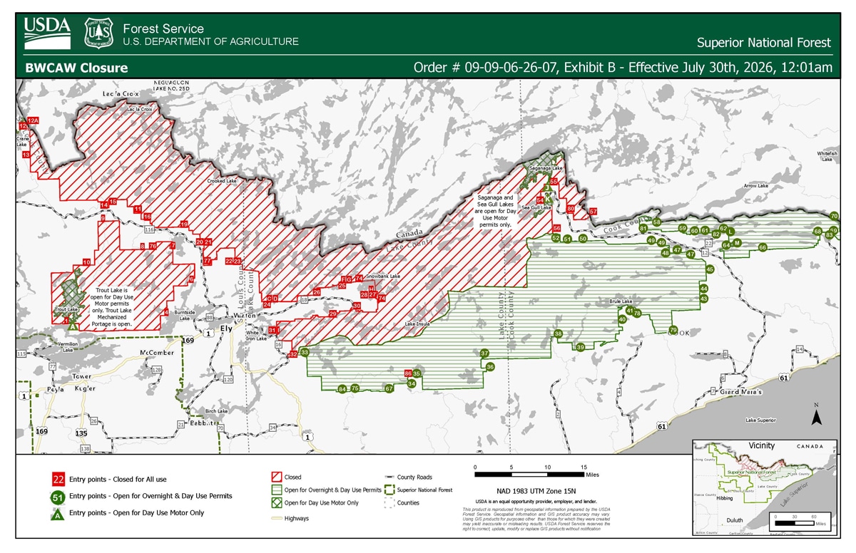


Phase 2 confirmed: overnight camping returns to 41 entry points July 30
The Forest Service confirmed Phase 2 of the reopening today: 41 entry points in the central and eastern BWCAW — about 432,500 acres, or 39% of the wilderness — will reopen for both day and overnight use starting Thursday, July 30, according to a Forest Service news release. All other entry points remain closed while multiple wildfires continue to burn in the area; permits for those entry points are cancelled from July 30 through August 3. “Protecting the public and firefighters’ [safety] remains the highest priority,” the agency said.
There are 2 additions to the list provided by the Forest Service last week: day-use motor access now opens on Saganaga and Sea Gull lakes in Cook County. St. Louis County still gets just one entry point back — Trout Lake, for day-use motor only. The confirmed entry points:
Gunflint Ranger District:
- 43 Bower Trout Lake
- 44 Ram Lake
- 45 Morgan Lake
- 47 Lizz and Swamp Lakes
- 48 Meeds Lake
- 49 Skipper and Portage Lakes
- 50 Cross River
- 51 Missing Link Lake
- 52 Brant Lake
- 58 South Lake
- 59 Partridge/South Lake Trail
- 60 Duncan Lake
- 61 Daniels Lake
- 62 Clearwater Lake
- 64 East Bearskin Lake
- 66 Crocodile River
- 68 Pine Lake
- 69 Little John Lake
- 70 North Fowl Lake
- 78 Brule Lake Trail
- 79 Eagle Mountain Trail
- 81, 82, 83 Border Route Trail (west, center, east)
- J Saganaga Lake (day-use motor)
- K Sea Gull Lake (day-use motor)
Tofte Ranger District:
- 34 Island River
- 35 Isabella Lake
- 36 Hog Creek
- 37 Kawishiwi Lake
- 38 Sawbill Lake
- 39 Baker Lake
- 40 Homer Lake
- 41 Brule Lake
- 67 Bog Lake
- 75 Little Isabella River
- 84 Snake River
Kawishiwi Ranger District:
- 33 Little Gabbro Lake
LaCroix Ranger District:
- A Trout Lake (day-use motor only)
July 24 update:
Phase 2 proposal: overnight camping at 37 BWCAW entry points could resume next week
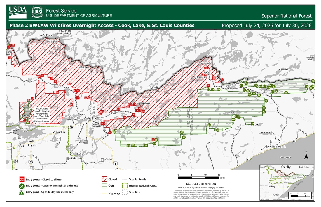
The Forest Service has proposed a second phase of reopening that would restore overnight access at 37 of the BWCAW’s 103 quota entry points — about 424,231 acres, or 39% of the wilderness — as soon as Thursday, July 30, barring significant wildfire activity over the weekend. A decision and implementation announcement is planned for Monday, July 27.
The Phase 2 proposal includes all the Phase 1 entry points and adds several in Lake County, plus a single St. Louis County entry: Trout Lake, for day-use motor only. The entry points under consideration:
Gunflint Ranger District:
- 43 Bower Trout Lake
- 44 Ram Lake
- 45 Morgan Lake
- 47 Lizz and Swamp Lakes
- 48 Meeds Lake
- 49 Skipper and Portage Lakes
- 50 Cross River
- 51 Missing Link Lake
- 52 Brant Lake
- 58 South Lake
- 59 Partridge/South Lake Trail
- 60 Duncan Lake
- 61 Daniels Lake
- 62 Clearwater Lake
- 64 East Bearskin Lake
- 66 Crocodile River
- 68 Pine Lake
- 69 Little John Lake
- 70 North Fowl Lake
- 78 Brule Lake Trail
- 79 Eagle Mountain Trail
- 81, 82, 83 Border Route Trail (west, center, east)
Tofte Ranger District:
- 34 Island River
- 35 Isabella Lake
- 36 Hog Creek
- 37 Kawishiwi Lake
- 38 Sawbill Lake
- 39 Baker Lake
- 40 Homer Lake
- 41 Brule Lake
- 67 Bog Lake
- 75 Little Isabella River
- 84 Snake River
Kawishiwi Ranger District:
- 33 Little Gabbro Lake
LaCroix Ranger District:
- A Trout Lake (day-use motor only)
Originally published July 23, 2026:
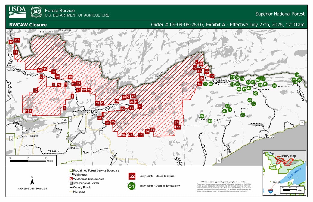
Ten days after wildfires closed the entire Boundary Waters Canoe Area Wilderness, the Forest Service announced the first step toward reopening it. Day-use permits for select entry points in Cook County will open for visitor use starting Monday, July 27, the agency said today. Day use at all other BWCAW entry points remains closed, and overnight permits for all entry points are cancelled through Wednesday, July 29 — no overnight camping is currently allowed.
Overnight camping could follow next week
More could follow soon. “If there is no major wildfire activity this weekend, the Boundary Waters Canoe Area Wilderness might partially open for overnight camping next week,” said Drew Stroberg, acting forest supervisor. “We are trying to balance visitor and firefighter safety with people’s desire to visit the Wilderness. We take both responsibilities very seriously.” Forest officials say they anticipate being able to open select entry points in Cook and Lake counties to overnight use next week, barring significant fire activity over the weekend.
Which entry points, and why Cook County first
The Cook County entry points opening Monday are in areas that have seen minimal wildfire activity and no new fire activity since the closure was issued, according to the agency. The specific entry points are listed in the forest order’s map (see above or available on the Superior National Forest alerts page). Most of the wilderness, the agency notes, remains greatly affected by uncontained wildfires, and the closed areas will stay closed until the fires are contained and the risk to the public and firefighters has decreased.
“We are hopeful” say outfitters
For outfitters on the east side of the wilderness, the day-use-first approach is what they’d hoped for. When the closure came down, Sawbill Canoe Outfitters owner Clare Shirley told Wilderness News that no fires were burning near or threatening the Sawbill area: “We are hopeful that if the closure extends beyond Friday, day trips will be allowed, given that there is no imminent danger or threat in our vicinity.” Ten days later, that’s the path the Forest Service has taken — the updated map shows the Sawbill Lake entry point (#38) among those opening to day use Monday, along with a string of entry points across the eastern wilderness off the Gunflint Trail and the Tofte district.
Plan carefully — it’s still fire season
The Forest Service urges visitors to plan diligently: leave a travel plan with family or friends, check weather and fire conditions before going, and understand the risks of entering a wilderness area during an active fire season. The forest has experienced more than 25 wildfires since July 7. Visitors with cooperator-issued permits should contact their cooperator about options; permit questions can go to 218-626-4314.
We will update this story as more areas reopen.
More information:
- Superior National Forest Alerts — forest order, Exhibit A list and Exhibit B map (USDA Forest Service)
- BWCAW trip planner (USDA Forest Service)
- July 2026 Superior NF Wildfires (InciWeb)
- Fire information: 218-881-2091 (8 am – 8 pm)
Get Fire Updates
Stay informed on recent wildfires, campfire bans, park closures, straight to your inbox.