

The Forest Service will temporarily close all BWCAW entry points effective 12:01 am Tuesday, July 14. See the full story.
The Forest Service is removing vehicles from the Little Indian Sioux North entry point (#14) parking lot, as the Sioux Fire — now 288 acres — burns toward the BWCAW. St. Louis County has raised its Ready-Set-Go evacuation status to SET for the Sioux Fire. See our fire update story for details.
July 11 Update:
Closure expanded to northwestern Gunflint Ranger District
The Forest Service is also closing public access to an area of the BWCAW in the northwestern portion of the Gunflint Ranger District, due to the nearby wildfire (FOR028) in Quetico Provincial Park. Forest Order Number 09-09-07-26-07 takes effect at 12:01 am Sunday, July 12. Maps and more information will be posted to the forest’s alerts page.
The following lakes, associated campsites, and portages are closed under this order:
- Ottertrack Lake
- Little Knife Lake
- Amoeber Lake
- Topaz Lake
- Cherry Lake
- Hanson Lake
- Ester Lake
- Rabbit Lake
- Clam Lake
- Ashdick Lake
- Swamp Lake
- Gijikiki Lake
- Rivalry Lake
- Lake of the Clouds
- Lunar Lake
Visitors are asked to stay away from the area. According to the Forest Service, visitors traveling on the Canadian side of these lakes can still access portages. Wilderness rangers will begin sweeping the closure area to notify visitors on Sunday, July 12. The closure will remain in effect until the fires are declared out, unless rescinded sooner. Contact your outfitter for information affecting your entry point or the Gunflint District Office, Grand Marais, 218-387-1750.


July 10 Update:
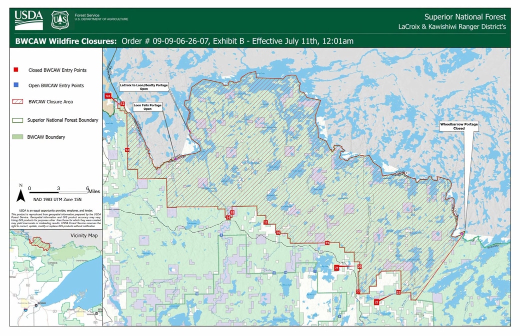
The USDA Forest Service is closing public access to three wildfire areas within the Boundary Waters Canoe Area Wilderness (BWCAW) to protect public health and safety, the agency announced July 10. The closed areas surround the Bear Trap, Thumb, and Wolfpack fires, all located in the LaCroix Ranger District of the Superior National Forest, in St. Louis County.
Forest Order Number 09-09-06-26-07, effective July 11, 2026, temporarily closes the affected areas due to active wildfires. Maps and more information are available on the forest’s alerts page. The Forest Service also issued campfire restrictions for the BWCAW, effective the same day.
For the current status of all wildfires burning on the Superior National Forest, see our fire update story.
Closed entry points, recreation sites, and trails
The following BWCAW entry points and associated recreation sites and trails are closed to the public due to the Thumb, Wolfpack, and Bear Trap wildfires:
- Angleworm Lake (OP) #20
- Angleworm Trail (OH) #21
- Blandin Trail (OH) #11
- Herriman Trail (OH) #13
- Little Indian Sioux River North (OP) #14
- Little Vermilion Lake (OP, OM) #12
- Lac La Croix Only (OP, OM) #12A
- Moose/Portage River North (OP) #16
- Mudro Lake – Restricted (OP) #22
- Mudro Lake (OP) #23
- South Hegman Lake (OP) #77
- Stuart River (OP) #19
- Sioux Hustler Trail (OH) #15
Contact your outfitter for the information affecting your entry point. For more information, contact the LaCroix District Office in Cook at 218-666-0020.
Phone information line:
A dedicated fire information line is now available for the July fires: 218-881-2091, staffed 8 am – 8 pm, or by email at 2026.JulyLightningEvent@firenet.gov.

Get Fire Updates
Stay informed on recent wildfires, campfire bans, park closures, straight to your inbox.
More information:
- Superior National Forest Alerts (USDA Forest Service)
- July 2026 Superior NF Wildfires (InciWeb)
- Superior National Forest Facebook Page