

All backcountry areas reopen, with advisories
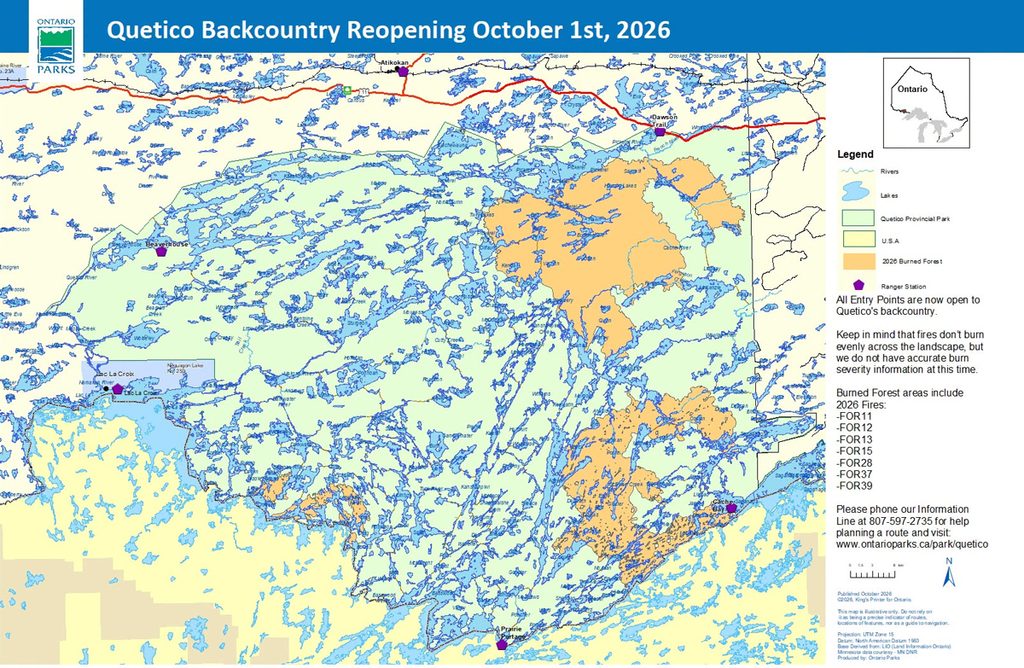
All backcountry areas of Quetico Provincial Park are now open, the park said on Facebook, though with advisories in place for burned areas. The park is discouraging travel in the burn area and pointed visitors to a map showing its boundaries. Impassable portage routes and overhead tree hazards are present throughout the area due to weakened root systems from the fires’ intensity, and the park is advising against camping under burned trees. It says it’s still gathering information on the severity of burned areas and recommends caution park-wide. Trip planning help is available through the Quetico Information Line, 807-597-2735.
August 29 update:
Quetico reopens four backcountry entry points; most remain closed
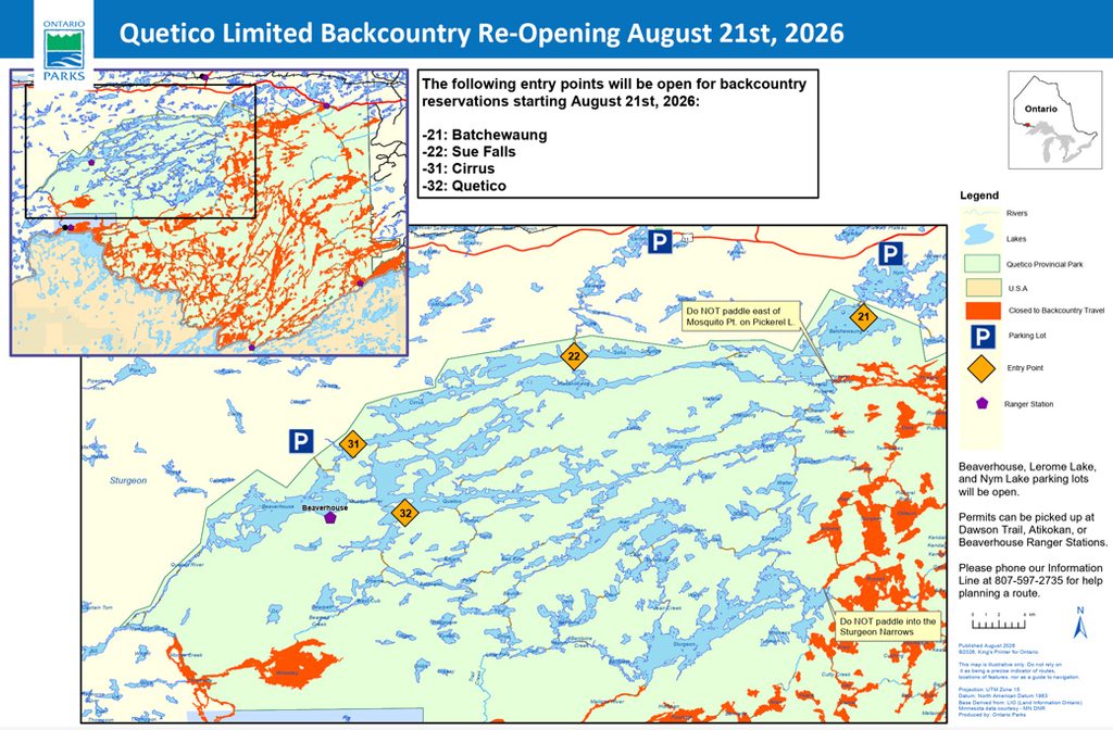
Limited backcountry reopening; most entry points closed through October 31
Quetico Provincial Park has reopened four backcountry entry points — Batchewaung Lake, Sue Falls, Cirrus, and Quetico — as of August 21, per a park notice.
The rest of the backcountry entry points remain closed due to impacts from nearby forest fires, and the park says they’ll stay closed until October 31: Agnes Lake, Agnes Lake/Basswood Basecamp, Baptism Creek, Basswood River, Bottle River, Boundary Point–Saganagons, Carp Lake, Falls Chain Lakes, Fly-In Access–Cache Bay, Kahshahpiwi, Kings Point Fly-In, Knife Lake, Mack Lake Fly-In, Maligne River, Man Chain Lakes, McAree Lake, Pickerel Lake, Sarah Lake, and Three Mile. That’s a longer closure than the park’s earlier proposed August 21 reopening for the full backcountry.
Visitors can check the park’s route closure map or call the Quetico Information Line, 807-597-2735, for trip planning. Reservation holders can change or cancel with no fee by calling 1-888-668-7275 (daily, 7 a.m.–9 p.m. ET).
August 14 update:
Dawson Trail Campground reopens; backcountry stays closed
Quetico Provincial Park says fire suppression units have been removed and the popular Dawson Trail Campground reopens to front-country campers Friday, August 14, at 2 p.m., per the park’s Facebook page. The park says it’s still working to confirm whether campground water is potable and will update visitors on that separately. Staff evacuated from French Lake housing during the fire were hosted by the community of Atikokan and by Blue Lake, Sleeping Giant, Earle Rowe, Kakabeka Falls, and Nagagamisis provincial parks, along with the Northwest Zone Park Office.
The backcountry and all backcountry entry stations remain closed, with the proposed reopening date August 21. The park will reassess August 17 on whether further cancellations are needed. Affected backcountry reservation holders may obtain a full refund or a no-penalty rebooking (subject to availability) by calling the park’s reservations line, 1-888-668-7275, rather than cancelling or changing online.

August 5 update:
Quetico has pushed its closure back again
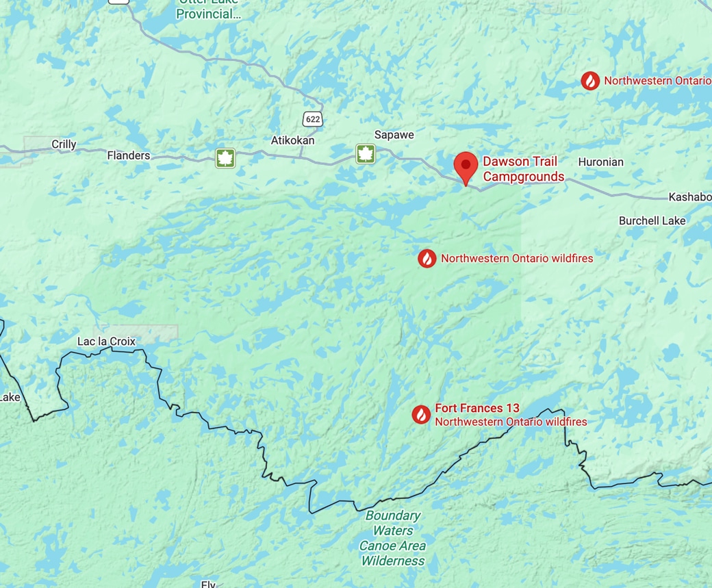
The Dawson Trail Campground — campsites, roofed accommodations, and all day-use areas — is now closed through August 14, extended from the previous August 8 target; the park will reassess on that date. The backcountry and all backcountry entry stations remain closed too, with a separate, later proposed reopening of August 21. As before, affected reservation holders will be contacted for a full refund or a no-penalty rebooking. Ontario’s evacuation alert for the Saganaga Lake area, tied to Fort Frances 13, remains active, unchanged since it was issued July 24.
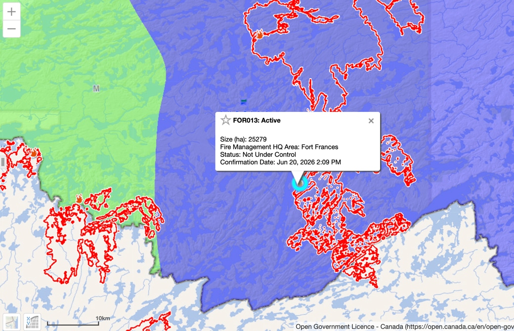
Fort Frances 13 — the Ontario side of the fire known as the Little Knife Fire in Minnesota — is now sized at 25,279 hectares (about 62,500 acres) and still not under control, according to Ontario’s August 3 forest fire update. That’s a sharp contrast to the US side of the same fire: the Little Knife Fire there reached 90% containment this week at 4,815 acres, with the US Forest Service returning management to local control and calling August 4 the likely final standalone daily report for that fire. One border-crossing fire, two very different pictures on either side of the line. See the Ontario interactive fire map.
Elsewhere in the Atikokan cluster nearest the park, Fort Frances 14 and 15 are largely unchanged in size — 51,768 and 42,273 hectares — with officials reporting relatively low fire behavior in recent weeks. Fort Frances 38, north of Crystal Lake, has been declared out at 44.2 hectares.
July 25 update:
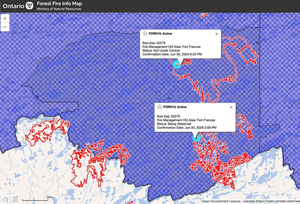
Quetico Provincial Park has extended its closure and now proposes to reopen August 8. The Dawson Trail Campground — campsites, roofed accommodations, and all day-use areas — remains closed, along with the entire backcountry and all backcountry entry stations, according to the park’s alerts page. The park says it will reassess on August 8 whether further cancellations are required; affected reservation holders will be contacted with full refunds or penalty-free changes. A fire ban remains in effect in the park, part of the Restricted Fire Zone covering Ontario’s entire Northwest Fire Region.
On July 24, the Ministry of Natural Resources issued an evacuation alert — not an order — for the Saganaga Lake area east of the park, citing the “evolving situation and increased fire behaviour” of Fort Frances 13, the Ontario designation for the fire known as the Little Knife Fire in Minnesota. The fire was mapped at more than 25,000 hectares (about 62,000 acres) on the Ontario side as of Friday — several times the size of its roughly 5,000-acre US footprint. People in the area “are strongly encouraged to prepare to evacuate on short notice,” the ministry said.
Elsewhere in the region, the Atikokan cluster — Fort Frances 14, 15, and 38, including the fire that prompted Quetico’s original north-end evacuations — has burned a combined 94,000-plus hectares with little recent change, and Ontario’s Northwest Fire Region counted 133 active wildfires as of July 25.
The extended Quetico closure stands in contrast to the US side of the border, where the Forest Service begins reopening select eastern BWCAW entry points to day use Monday.
More info:
- Quetico Provincial Park alerts
- NWONewsWatch on the MNR evacuation alert
- Ontario Forest Fire Info Map
Wildfire prompts evacuations and lake closures in Quetico
July 11 update:
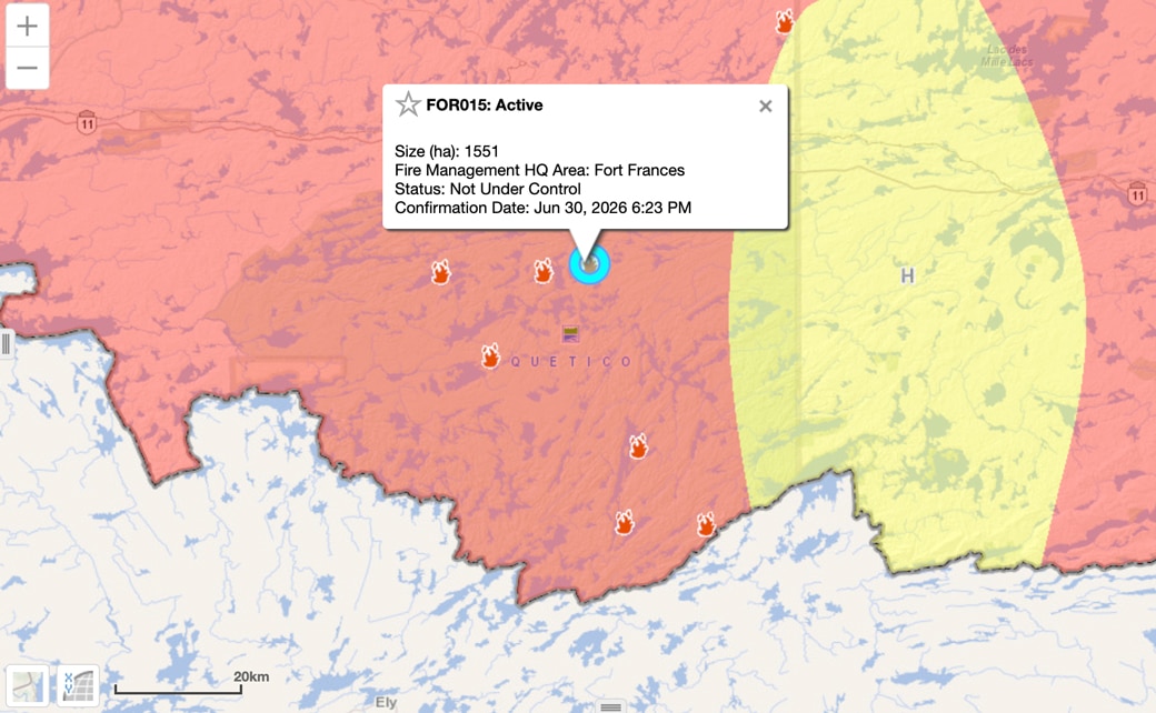
Quetico Provincial Park has evacuated and shut down a sweep of lakes across its north end as forest fire FOR015 sends smoke — at times heavy enough to degrade air quality — over the park. “Public safety is our top priority,” the park said in a notice posted to its alerts page, and the closure will be lifted once conditions allow.
Fire: Fort Frances 15 (FOR015)
Size: 1,551 hectares (about 3,800 acres)
Status: Not under control
July 8 update:
Fire: Fort Frances 15 (FOR015)
Size: 1,300 hectares (about 3,200 acres)
Status: Not under control
Cause: Not yet determined
Location: Near Olifaunt Lake, about 28 kilometres (17 miles) southeast of Atikokan, Ontario, in the north-central portion of Quetico Provincial Park

July 7 update:
Fire: Fort Frances 15 (FOR015)
Size: 800 hectares (about 2,000 acres), per the MNR Forest Fire Info Map, July 6
Status: Not under control
Cause: Not yet determined
Location: Near Olifaunt Lake, about 28 kilometres (17 miles) southeast of Atikokan, Ontario, in the north-central portion of Quetico Provincial Park
The fire was confirmed late on June 30 near Olifaunt Lake, according to Ontario’s Aviation, Forest Fire and Emergency Services, and has grown explosively: first reported at 10 hectares on July 1, it stood at 800 hectares — roughly 2,000 acres — and not under control on the Ministry of Natural Resources’ Forest Fire Info Map as of July 6.
An updated closure map published by the park on July 6 shows closed lakes and portages across a wide swath of the park’s north end, including Pickerel, Doré, Beg, Bisk, Bud, Fern, Art, Rawn, Buckingham, Olifaunt, and Acheson lakes. Paddlers are asked to reroute away from the closure area.

Park officials plan to take stock again on July 10 and decide whether more reservations must be cancelled.
Anyone holding a permit in the closure area can get a full refund, or switch to a different entry point penalty-free where space exists — but only by phone, through the Ontario Parks reservations team at 1-888-668-7275; the park warns against cancelling or changing bookings online.
Paddlers trying to re-plan a route around the closure can reach park staff on the Quetico information line, 807-597-2735.
Get Fire Updates
Stay informed on recent wildfires, campfire bans, park closures, straight to your inbox.
A second fire in the park
A second, much smaller fire, Fort Frances 17 (FOR017), was confirmed on July 3 near Kasakokwog Lake, approximately 15 kilometres (9 miles) south of Atikokan. It never gained ground: the MNR fire map now lists it as out at 0.9 hectares.
Both Quetico fires come amid a busy stretch for crews across northwestern Ontario, where fire officials counted 76 active blazes on the evening of July 5, 16 of them not yet under control. The Fort Frances district’s largest, FOR014 near Byers Lake southwest of Upsala — well outside the park — had grown to roughly 1,480 hectares.
More information:
- Ontario Parks — Quetico alerts
- Quetico Provincial Park on Facebook (closure map)
- Ontario forest fire interactive map