

All fires declared 100% contained
InciWeb’s incident overview for the July Lightning Incident now confirms the Sioux, Bear Trap, Thumb, and Little Knife fires are all 100% contained and in patrol status. According to the U.S. Forest Service, September 4 was the last standalone daily update. Sioux, Bear Trap, and Thumb hold at their prior acreages — 6,833, 39,327, and 25,515 total acres, respectively — and the incident’s total footprint remains 71,675 acres. All fires are now under Superior National Forest management, with personnel down to 18. This is likely the final entry in this tracker; we’ll follow any further news through the forest’s website and Facebook page.
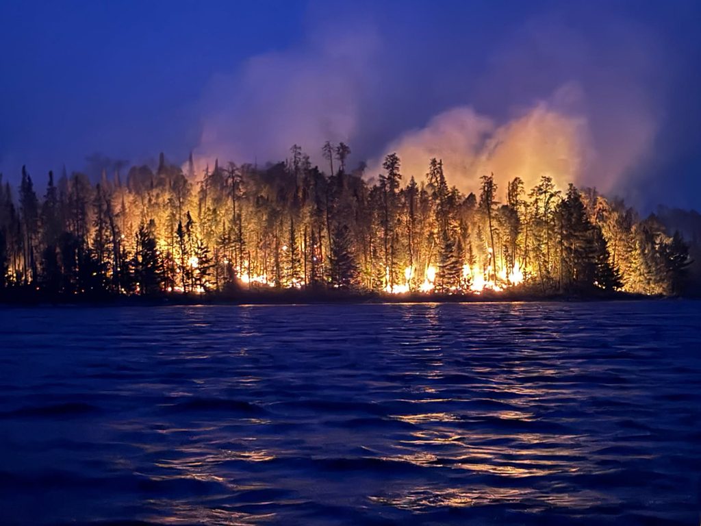
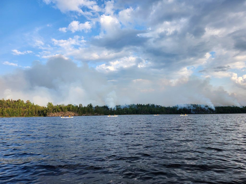
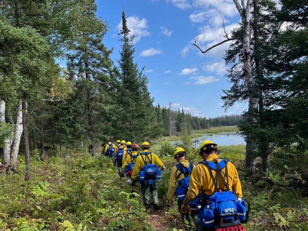
The summer of fire:
September 4 update:
First day since early July with no firefighting operations needed in the BWCAW
Today was the first day since early July that no firefighting operations were needed in or around the BWCAW. Boats and helicopters have backhauled the remaining equipment, canoes, and supplies from the wilderness, and Forest Service personnel will continue patrolling affected areas by ground and air. Today’s report is also the last standalone daily update for the July Lightning Incident: NIMO Team 1 transfers command back to the Superior National Forest on Monday, September 7, and the agency says future closures, reopenings, and fire-related information will come through the forest’s website and Facebook page rather than a daily incident report.
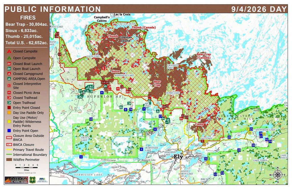
Sioux, Bear Trap, and Thumb all remain at 97% contained, with the incident’s footprint unchanged at 71,675 total acres (62,652 US, 9,023 Canada) and personnel down to 193. About 150 of the BWCAW’s roughly 2,000 campsites still show some level of wildfire effect. Six entry points reopen Tuesday, September 8, under Phase 10, as previously reported: #12, #12A, #13, #22, #23, and #24, along with the Ed Shave Road boat launch, Meander Lake picnic area and backcountry sites, and the Fire and Ice Interpretive Trail. Rain Thursday into Friday brought 0.5 to 0.75 inches to the fire footprint, with more chances into next week continuing to dampen remaining areas of heat; little to no fire behavior was observed.
August 31 update:
Sioux and Bear Trap near full containment; temporary flight restrictions rescinded
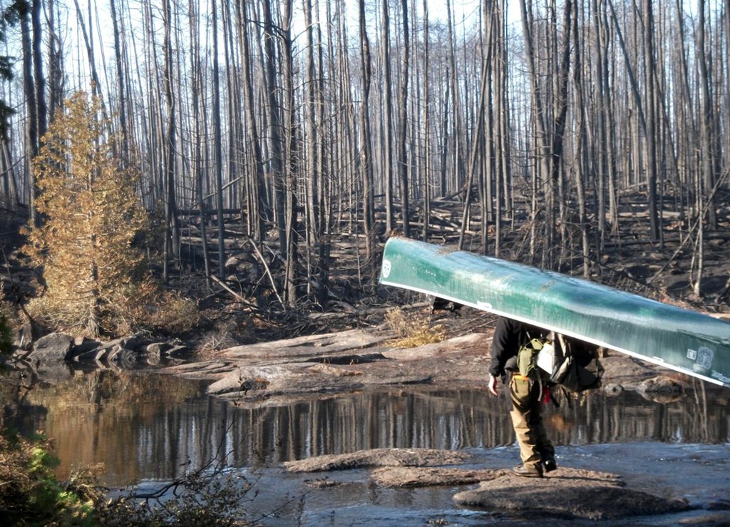
Containment surged over the weekend: Sioux reached 94% contained (up from 79%) at 6,833 acres, and Bear Trap reached 92% contained (up from 67%) at 39,327 total acres (30,804 US) — both fires now effectively winding down. Thumb held closer to steady at 59% contained (from 58%), with a total of 25,015 acres, including 500 acres (2%) in Canada. Temporary flight restrictions over the fire area have been rescinded entirely — only the BWCAW’s permanent flight restriction remains. Personnel eased further to 324 (from 439), and the broader incident’s US acreage ticked up slightly to 62,652 (from 62,152), with the total holding at 71,675 (62,652 US, 9,023 Canada).
More than 100 firefighters and heavy equipment are working the Echo Trail this week to finish an extensive fuel break, with boat and helicopter missions also scheduled to backhaul remaining contingency equipment from the Thumb and Bear Trap fire areas. Wilderness rangers are actively assessing the safety of portages, landings, and about 150 campsites in fire-affected areas still closed to the public. Entry Point #12 (Little Vermilion Lake) reopens for day use tomorrow, September 1, along with Lake Jeanette Campground, its boat launch, backcountry sites, and Nels Lake.
After light overnight showers and scattered lightning, a multi-day drying and warming trend begins today, with highs in the high 70s to low 80s, humidity near 50%, and southwest winds increasing to gusts over 25 mph by Tuesday. Continued smoldering is expected.
August 28 update:
Command transition complete; Little Knife reaches 95% contained; Camp drops out of the combined count
The incident command transition is complete: NIMO Team 1 assumed full command Thursday of the Sioux, Bear Trap, and Thumb fires, while the Superior National Forest resumed local command of the Camp Fire (4,357 acres, 97% contained, unchanged) now that it’s largely wound down. Because Camp is no longer tracked under the combined incident, today’s “July Lightning Fires” total — 71,675 acres (62,152 US, 9,023 Canada) — reads lower than Wednesday’s, not because of any acreage loss elsewhere. Personnel eased to 439 (from 491). The Little Knife Fire improved to 95% contained (from 90%), still at 4,815 acres, and the Muskeg Creek Fire remains 100% contained; both are now under Forest patrol rather than standalone daily tracking.
Bear Trap improved to 67% contained (from 65%) at 39,327 total acres (30,804 US), with crews continuing suppression repair — soil stabilization and erosion control — after finishing their pullout from the BWCAW earlier in the week. Sioux held at 79% contained, 6,833 acres, with about a week of chipping left to finish the shaded fuel break along the Echo Trail. Thumb is listed at 58% contained, 25,515 total acres, but today’s report gives its US-only figure as 20,515 acres — down sharply from the 25,015 US acres reported August 26 with the same total.
Overnight temperatures were the coolest of the incident so far, with a multi-day drying trend underway and temperatures rising through the weekend; officials expect smoldering to increase as it warms. Crews are using an infrared-equipped drone today to check for heat in uncontained areas. Saturday and Sunday bring a chance of showers and isolated thunderstorms, with winds shifting out of the southwest. Two BWCAW entry points reopen soon: #D (Fall Lake-Newton-Pipestone Bay) for day use Saturday, August 29, and #12 (Little Vermillion Lake) for day use, along with Lake Jeanette Campground and Nels Lake, on September 1.
August 26 update:
New incident team takes over as Bear Trap’s containment jumps to 65%
The National Incident Management Team One is taking over the July Lightning Incident from the Southern Area Complex Incident Management Team One in the coming days, the outgoing team said in today’s update, thanking the communities around the forest for their hospitality. Bear Trap posted the day’s biggest gain, reaching 65% contained (up from 55%) at 39,327 total acres (30,804 US), with all crews now out of the BWCAW and shifting to suppression repair — including soil stabilization and erosion control along the Angleworm Trail. Sioux climbed to 79% contained (from 76%) at 6,833 acres, and Thumb improved to 58% contained (from 55%) at 25,515 total acres (25,015 US), with all spike camps broken down and the fire now patrolled by air. Camp held at 97% contained, 4,357 acres; rain delayed suppression-repair work Tuesday, but crews expect to finish it today.
The Muskeg Creek Fire remains 100% contained, though firefighters continue to assess it. The Little Knife Fire is unchanged at 4,815 acres and 90% contained. The broader incident held flat at 76,032 total acres (67,009 US, 9,023 Canada), with personnel easing sharply to 491 (from 598). The forest also confirmed fire restrictions are lifted across the entire forest, including the BWCAW, as we reported yesterday — though restrictions remain in place at Grand Portage. Along the Echo Trail, about three more days of mastication work and roughly eight days of chipping remain to complete the shaded fuel break. Lake Jeanette Campground, its boat launch, and dispersed sites stay closed for now due to the Sioux Fire.
August 25 update:
Muskeg Creek Fire reaches full containment; all crews pulled from the BWCAW ahead of storms
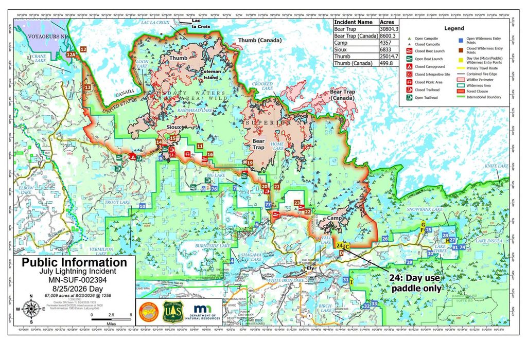
The Muskeg Creek Fire, reported August 23 near Caribou Point on Pipestone Bay, is 100% contained, the incident team said today — a fast resolution with no acreage figure given. Today’s update didn’t include updated acreage, containment, or personnel figures for the incident’s other fires.
There is an increased chance of thunderstorms this evening — some potentially strong to severe, with gusty outflow winds, frequent lightning, small hail, and moderate to heavy rain.
All crews have been pulled out of the Boundary Waters ahead of the incoming weather and are shifting to suppression repair work as conditions allow. The two BWCAW entry points announced for today — #9 (Little Indian Sioux River South) and #77 (South Hegman Lake) — have reopened as scheduled.
August 24 update:
New fire reported at Caribou Point; Sioux’s containment jumps to 76%; forest eases to Class II restrictions
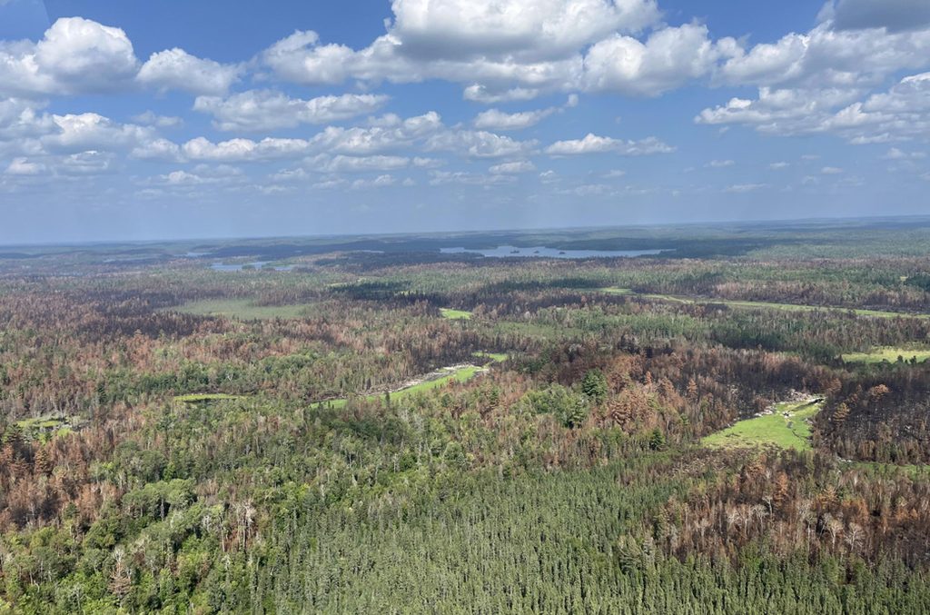
A new fire, the Muskeg Creek Fire, was identified yesterday in the Caribou Point area of Pipestone Bay; crews were assessing it and its resource needs today, with no acreage or containment figures yet reported. Separately, the Forest dropped to Class II fire restrictions at noon today, allowing campfires in the BWCAW and at dispersed and backcountry campsites, within designated metal fire rings — a further easing from the Class III restrictions in place since late July.
Containment gains were sharp across the incident’s larger fires. Sioux jumped to 76% contained (from 53%) at 6,833 acres, though a drone identified two areas of remaining heat on Jeanette Creek, on the fire’s southwest side, which crews are continuing to monitor. Bear Trap improved to 55% contained (from 51%) at 39,327 total acres (30,804 US), with crews finishing suppression repair on the Angleworm Trail and mopping up along the fire’s eastern and northeastern edge; a drone found no significant heat on the southeast portion. Thumb also climbed to 55% contained (from 46%) at 25,515 total acres (25,015 US) — crews found no containment threats after patrolling its north and northeast portions over the weekend, and have dismantled all spike camps, with the fire now monitored by air daily. Camp held steady at 97% contained, 4,357 acres, with crews focused on suppression repair along the Great Fall Trail and Echo Trail corridor. The Little Knife Fire remains unchanged at 4,815 acres and 90% contained. The broader incident grew to 76,032 total acres (67,009 US, 9,023 Canada), with personnel easing to 598 (from 619).
Two BWCAW entry points reopen August 25, under Phase 8
Tomorrow, two additional entry points will reopen: #9 (Little Indian Sioux River South) and #77 (South Hegman Lake). Lake Jeanette Campground, its boat launch, and nearby dispersed sites remain closed due to the Sioux Fire, with Echo Trail delays of an hour or more still possible. Dry conditions continue today, but a low-pressure system brings at least two chances of rain and thunderstorms Tuesday, one in the morning and another in the afternoon and evening.
August 17 update:
Evacuation orders lifted in St. Louis and Lake counties; Thumb and Wolfpack merge into one fire
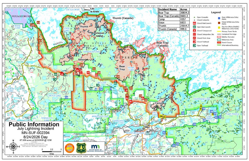
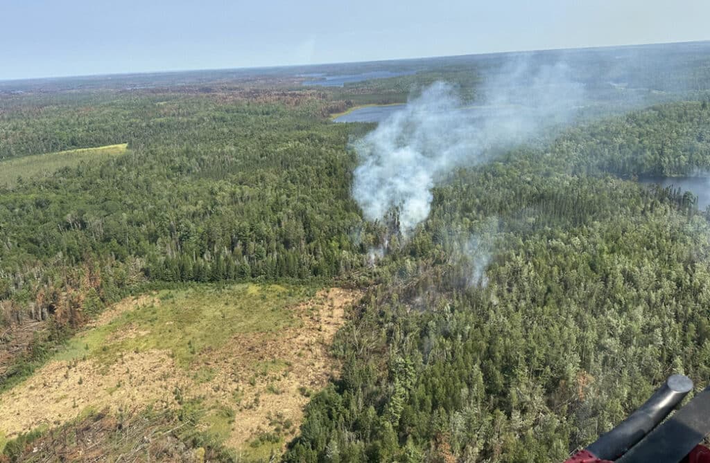
All evacuation orders in St. Louis and Lake counties have been lifted, the Forest Service said in today’s update — the incident’s most significant milestone yet on the evacuation front. Separately, the Thumb Fire has burned into the Wolfpack Fire, and the two are now tracked as a single fire under the Thumb name: 25,253 total acres (24,755 US), 44% contained. Crews are holding and controlling tactical burns on its west flank and working directly at the fire’s edge on the northwest flank, moving west from the Takuemich Lake area toward Gun Lake; hoses and sprinklers have been installed on Coleman Island.
Camp reached 97% contained at 4,357 acres — firefighters are now extinguishing heat on the southern flank of a spot fire east of the main fire, near Muskeg Creek, with chipping along the Cloquet Line expected to finish in two days. Sioux climbed to 55% contained (6,875 acres), with crews cold-trailing and mopping up hot spots north of the Echo Trail and moving north along the fire’s west flank toward the Little Indian Sioux River. Bear Trap improved to 45% contained at 38,505 total acres (30,110 US), with firefighters scouting new fire line on its southeastern tip between Gull and Boot lakes, developing a helispot near Friday Bay, and building containment lines along portages from Papoose to Chippewa to Nikki lakes; a separate crew is patrolling the fire’s northwest tip to keep it from threatening the La Croix Cabin. The Little Knife Fire remains unchanged at 4,815 acres and 90% contained. The broader incident grew slightly to 74,990 total acres (66,097 US, 8,895 Canada), with personnel easing to 656 (from 682).
Along the Echo Trail, shaded fuel break logging is expected to continue about four more days, with three and a half miles of road still to be logged and substantial travel delays expected. More than an inch of rain fell across most of the fire area Saturday into Sunday, moderating fire behavior to “active creeping,” though yesterday’s winds have already dried out surface duff in less-sheltered areas.
August 14 update:
New team takes command as Camp Fire nears full containment and Sioux’s containment jumps to 50%
The Southern Area Complex Incident Management Team 1 has assumed command of the July Lightning Incident, the Forest Service said in today’s update. As of August 13, more than 1,600 of the roughly 2,000 campsites are available, “restoring access to approximately 73% of the BWCAW”.
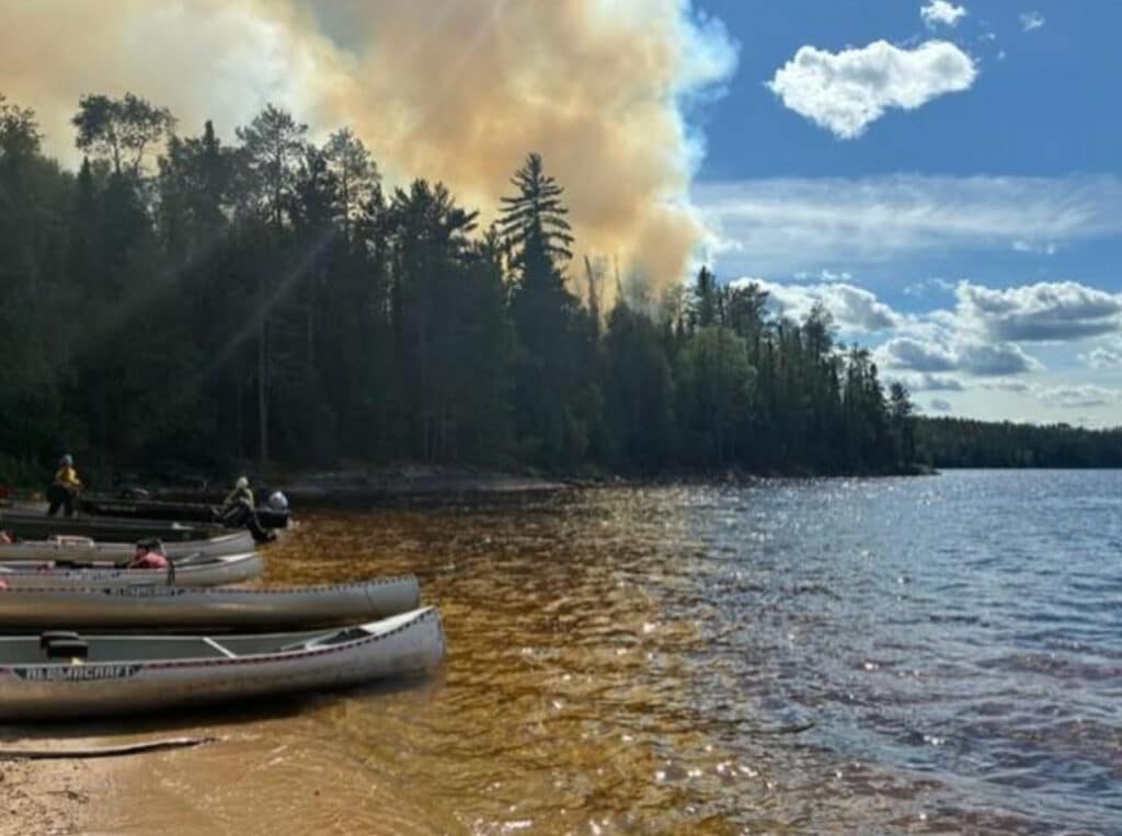
Containment gains were sharp on two fires. Camp reached 94% contained (up from 84%), with crews completing the last section of constructed fire line south from Back Bay and expecting to finish remaining cleanup and reinforcement by end of day — a “significant step toward containing” the fire, per the agency; its footprint held essentially flat at 4,357 acres. Sioux jumped to 50% contained (up from 35%), at 6,872 acres, as crews connected work near Ramshead Lake to established fire line and hose systems; the agency called its western side “stable” with “no significant concerns.”
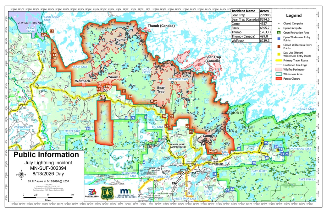
Wolfpack’s containment dipped to 20% (from 23%) and its acreage grew to 6,871 (from 6,239) — but the agency attributed both to a deliberate tactic, not spread: recent operations connected the Wolfpack and Thumb fires along Loon Lake, intentionally burning unburned fuel between them to reduce the potential for extreme fire behavior and lower threats to nearby portages and structures. The fire’s southern portion has also advanced into rugged, hard-to-access terrain that crews are monitoring rather than actively working. Bear Trap improved to 44% contained (from 41%) at 38,386 total acres (29,991 US), with crews progressing north along the Angleworm Trail and reinforcing lines between Gun, Wagoosh, and Niki lakes. Thumb held at 48% contained, essentially flat at 18,128 total acres (17,628 US), with crews mopping up and cold-trailing near Slim Lake while conducting tactical firing north from Loon Lake and relocating a basecamp on the northeast side. The broader incident grew to 74,614 total acres (65,719 US, 8,895 Canada), with personnel easing to 682 (from 761). The Little Knife Fire remains unchanged at 4,815 acres and 90% contained, now with just 4 personnel on the ground.
The agency says shaded fuel break work will continue along the Echo Trail from Forest Road 200 to North Arm Road for at least two more weeks, and warns of substantial travel delays for anyone using that road in the meantime.
August 9 update:

Camp Fire 84% contained; 73% of BWCAW is now open
Containment on the Camp Fire, burning about five miles north of Winton, jumped to 84% today – one of the largest single-day gains reported since the fires began. Its footprint has held steady at 4,359 acres.
The Forest Service also updated how much of the Boundary Waters is open to visitors, putting the figure at 73%, tied to the campsite reopenings taking effect August 13 under Phase 7.
Across the wider July Lightning Incident, combined burned acreage grew slightly to 73,902 (65,295 in the US, 8,607 in Canada), while assigned personnel eased to 773, down from 823 the day before. Containment also ticked up slightly on the Sioux Fire, to 35% (7,041 acres); the Wolfpack (23%, 6,239 acres), Bear Trap (40%, 38,129 total acres/30,022 US), and Thumb (48%, 18,134 total acres/17,634 US) fires held steady.
Crews finished the containment line on Wolfpack’s west side Saturday, extending a handline from the end of Forest Road 199 north to the Loon River, and firefighters are being deployed to Pauness Lake today to begin direct attack on a remote section of that fire. Structure protection measures at the LaCroix cabin (Bear Trap Fire) will be completed and that crew extracted today. Other work continues on Sioux’s east side from the Echo Trail north and east to Ramshead Lake, on Bear Trap’s southeast finger toward Friday Bay, on Thumb southwest of Takucmich Lake and in the Kelsey Lake area, and on a Camp finger between Pipestone Bay and Back Bay. The Little Knife Fire (4,815 acres, 90% contained) remains largely unchanged, with six personnel on the ground and no smoke visible in a recent reconnaissance flight.

Thumb Fire growth stalls after Wednesday’s spot fire
The incident’s combined US acreage was essentially unchanged at 65,145, per today’s daily update, while personnel jumped to 917 (up from about 717 Tuesday) as crews continue establishing themselves in remote areas. The Thumb Fire — which had been growing daily — held flat at 18,193 total acres (17,693 US) and 50% contained; crews contained a 2-acre spot fire that crossed the Slim Lake-Fat Lake portage Wednesday and are now patrolling and fortifying that line as a primary containment feature, while also testing network and radio systems being brought into the area. Crews are also placing a temporary radio tower and remote weather station to help manage the fire.
Bear Trap held at 37,871 total acres (29,764 US) and 40% contained, with firefighters working to access the southeast tip near Boot Lake — slowed by falling snags and rocky terrain — and a drone searching for hot spots today. Sioux was unchanged at 7,094 acres and 21% contained, with crews finishing containment of the portion south of the Echo Trail. Wolfpack grew slightly to 6,235 acres (from 6,228) at 23% contained, with containment line construction from Forest Road 199 to Loon Lake “progressing well.” The Camp Fire dipped slightly to 64% contained (from 65%) at 4,359 acres, with chipping complete along Forest Road 460 and crews planning direct suppression at the fire’s south end and indirect tactics in the Muskeg Creek area.

August 5 update:
Echo Trail reopens to residents; Thumb’s containment slips as it keeps growing
Residents and property owners regained 24-hour access to the Echo Trail today. With Little Knife and Chub now off the daily report, the incident’s remaining fires pushed combined US acreage to 65,150, even as personnel dropped sharply to about 717. The Thumb Fire kept growing, to 18,191 total acres (17,691 US), and its containment slipped to 50% – logistics teams are planning a repeater radio and a helicopter landing zone to support an influx of firefighters there. Bear Trap held at 40%, Camp at 65%. Sioux grew slightly to 7,094 acres and its containment improved to 21% (up from 16%), while Wolfpack grew to 6,228 acres at 23% contained. The Finstad Fire remains at a tenth of an acre.
Overnight temperatures dropped into the 40s, and cooler weather with light winds is expected to keep fire behavior mild today, though officials flagged a continued risk from dead or fire-weakened trees falling in work areas as winds shift over the next few days.


August 4 update:
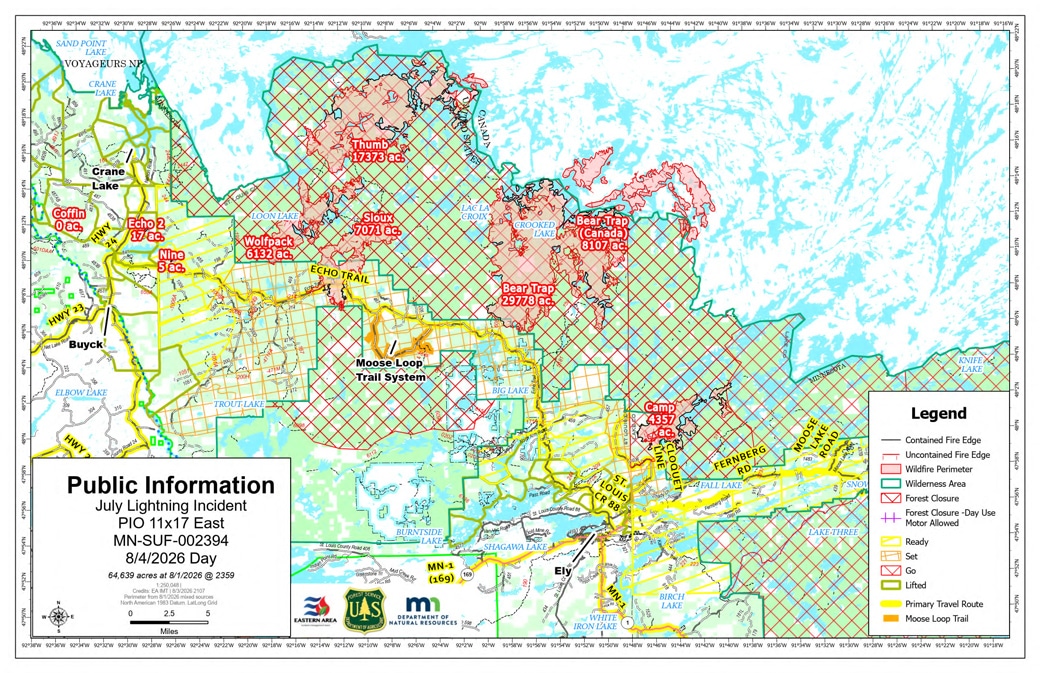
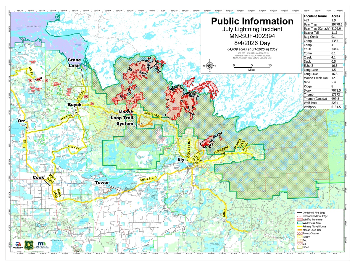
Little Knife and Chub reach their final updates
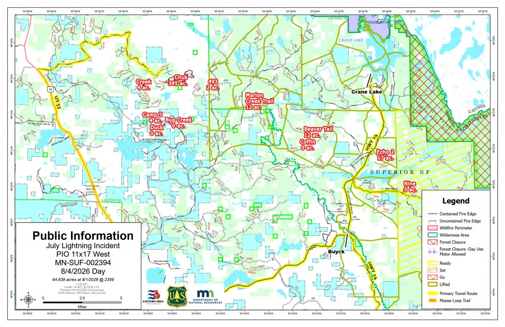
Little Knife hit 90% contained and Chub reached full containment — both fires get their last standalone daily report from the incident team, according to today’s update, “unless there’s a significant change in conditions” for Little Knife. Management of both fires returns to the Superior National Forest this evening. Overnight rain slowed fire activity despite gusts to 35 mph, and the fire stayed within containment lines; cooler, drier weather is expected over the next few days.
Growth continues at Thumb; Camp’s containment dips
The Thumb Fire grew to 17,873 total acres (17,373 US), still 57% contained, as crews attempt a second flight into the Loon Lake area after Monday’s weather grounded them. Sioux (16% contained, 7,071 acres) and Wolfpack (25% contained, essentially unchanged at 5,715 acres) held steady; Sioux crews are also retrying a flight into the Ramshead Lake area today after Monday’s attempt was weathered out. Camp’s containment dipped to 65%, down from Sunday, per today’s report. The combined incident held steady at 64,718 US acres, with personnel reduced to about 875.
Fall Lake and Fenske Lake campgrounds reopen August 7
The Forest Service will reopen the Fall Lake and Fenske Lake Campgrounds in the Kawishiwi Ranger District on August 7 — the first time either has been accessible since closing July 15. Moderating wildfire activity nearby allowed the reopening, though the agency says it could be revisited if conditions change. The Lake Jeanette Campground, off the Echo Trail, remains closed due to ongoing wildfire suppression activity nearby; reservation cancellations for still-closed developed sites on the forest’s west side have been extended through August 10.
Echo Trail access for residents
The Echo Trail’s daily closure (9:30 a.m.-7 p.m.) is in effect today only; residents and property owners get 24-hour access starting Wednesday at 9:30 a.m.
August 3 update:
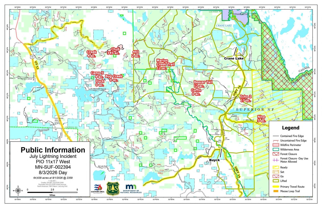
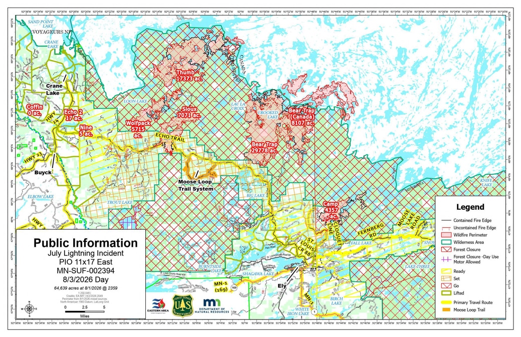
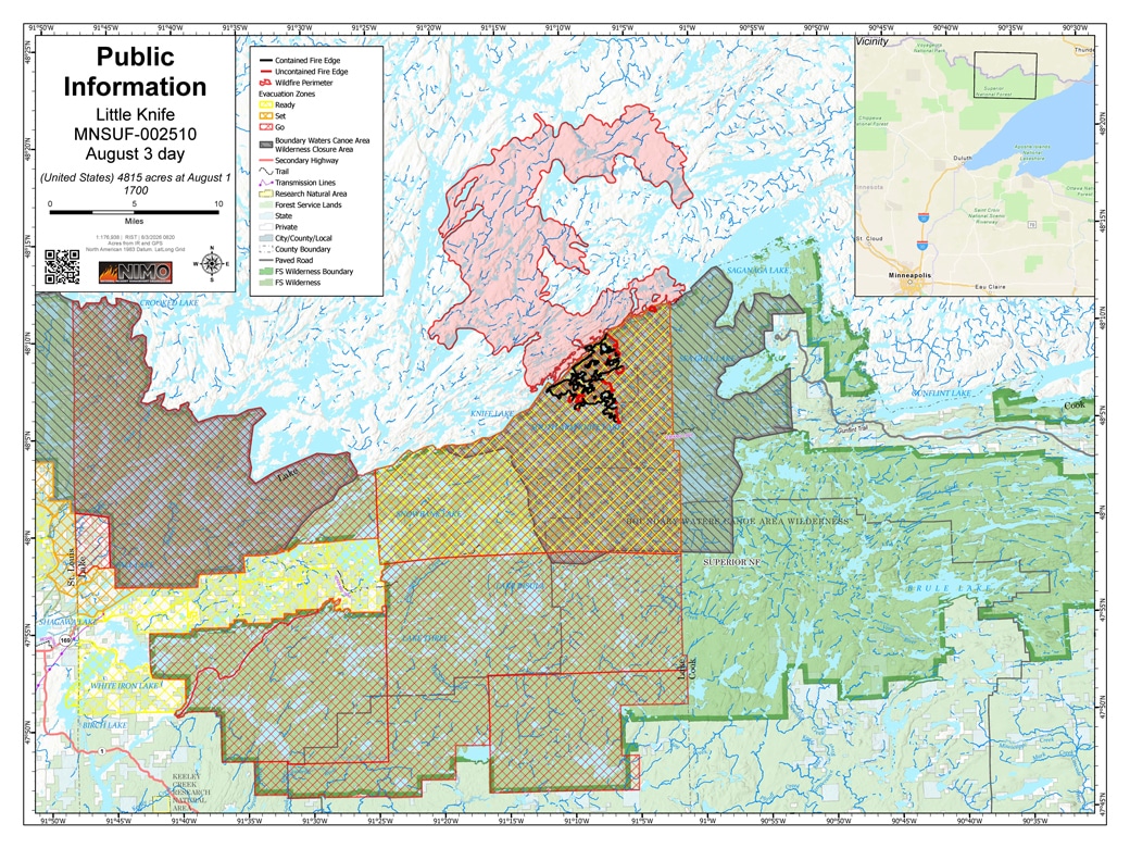
Little Knife nears handoff back to the forest at 90% contained
Little Knife jumped to 90% contained, with its acreage refined down to 4,815. Firefighters are canoeing out of the BWCAW today as the fire demobilizes — management returns from the National Incident Management Organization to the Superior National Forest the evening of August 4.
Fire activity picks up near Loon Lake
The incident’s combined US acreage climbed to 64,718, with officials citing increased fire activity particularly around Loon Lake. The Wolfpack Fire — north of the Echo Trail and east of Loon Lake, one of the three fires named in the original July 12 closure order but absent from recent daily updates — is now being tracked at 5,751 acres and 25% contained, with crews accessing its south end by canoe and foot. The Sioux Fire’s own figures dropped sharply in the same update, to 7,071 acres and 16% contained, from 12,709 acres and 42% the day before; the agency didn’t explain the change. Thumb, also near Loon Lake, reports fire behavior “steadily increasing” over the last few days, with crews being inserted to build line from Slim Lake to Fat Lake. Camp (69%), Bear Trap (40%), and Chub (96%) held closer to steady, and the Finstad Fire remains at a tenth of an acre. Personnel eased to 960 on the broader incident (from 1,042 the day before), even as Little Knife held at 132.
Wind shift, possible storms overnight
Winds out of the south and southeast increase to 25 mph today, likely flaring stagnant hot spots and smoke. A cold front moves in overnight, shifting winds northwest and possibly bringing up to a quarter inch of rain and gusts to 35 mph; officials also flagged a falling-tree risk to firefighters from the wind.
August 2 update:
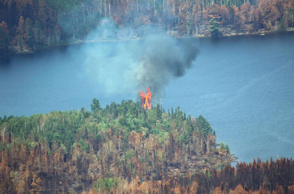
Containment of fires increasing, additional BWCA entry points reopening August 4
The Forest Service says it plans to reopen additional portions of the BWCAW for day and overnight use on August 4 in the Tofte and Gunflint Ranger Districts, after evaluating fire activity, weather conditions, and available resources. The agency’s notice doesn’t specify which entry points are included. The Forest Service’s updated closure list shows the full Gunflint Ranger District entry point roster reopening for overnight use August 4. Permits for areas still affected by the Bear Trap, Sioux, and Thumb fires remain cancelled, and three entry points directly damaged by the fires — Little Indian Sioux River North, Sioux-Hustler Trail, and Stuart River — are cancelled for the rest of the permit season, through September 30, pending rehabilitation. See our reopening story for lists of entry points.
Little Knife hits 85% contained as crews prepare to pull out
Little Knife jumped to 85% contained, and firefighters are removing gear from the BWCAW today ahead of canoeing out Monday — a sign the fire is being wound down. Camp (69%), Sioux (42%), Bear Trap (39%), Thumb (57%), and Chub (96%) held roughly steady, though Chub is also nearing full containment and reallocating equipment to other fires while starting landscape repairs from suppression work. A new fire, the Finstad Fire near Finstad Lake by Buyck, was detected August 1 from lightning and is being fought from the air; it’s currently a tenth of an acre. The incident’s US acreage ticked up to 64,249, with personnel at 1,042 on the broader incident and 132 on Little Knife.
Fire behavior picked up over the weekend as humidity dropped to 30% Saturday, including isolated tree torching. Winds are shifting south and southeast today at 10 to 15 mph, gusting to 30 mph by Monday — a shift that could push fire into unburned vegetation, though officials say ground moisture should limit spread.

July 31 update:
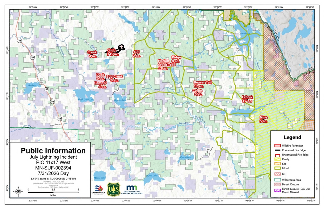
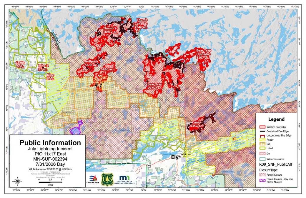
New team takes command as containment jumps on Camp and Little Knife
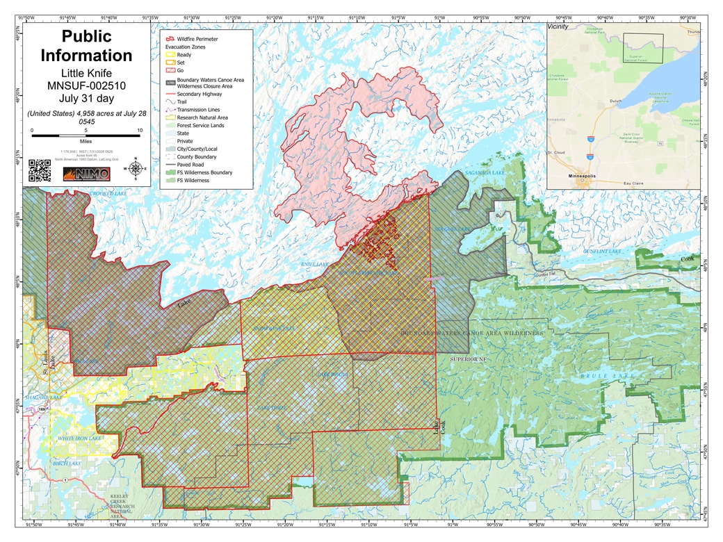
The Eastern Area Incident Management Team assumed command of the July Lightning Incident at 6 a.m. July 31, with Maris Gabliks as incident commander. Containment surged on two fires: Little Knife jumped to 70% (up from 49%), and Camp rose to 69% (up from 53%), with Camp’s acreage revised down slightly to 4,357 — reflecting more accurate mapping, not fire shrinkage. Sioux (42%), Bear Trap (38%), Thumb (57%), and Chub (96%) held steady. The combined incident remains at 64,076 US acres, with personnel easing to 995 on the broader incident and 131 on Little Knife.
Overnight thunderstorms dropped up to 0.79 inches of rain across the fire area’s western and northern sections. A cold front behind the storms is expected to bring drier, cooler weather and subdued fire activity over the next few days.
July 30 update:
Camp’s containment climbed to 53% (up from 46%), while Sioux, Little Knife, Bear Trap, Thumb, and Chub held roughly steady. Personnel grew to 1,053 on the broader incident and 143 on Little Knife, with total acreage essentially flat at 64,076 US acres. Fire behavior was expected to pick up after a four-day drying trend, potentially bringing more visible smoke, though forecasters said the afternoon thunderstorm chance had decreased.
July 29 update:
Sioux containment jumps to 42%, DNR fires declared out
Personnel grew to 1,038 on the broader incident and 139 on Little Knife, even as total acreage held steady at 64,054 US acres. Sioux made the biggest jump, to 42% contained (up from 27%), while Camp held at 46%, Little Knife at 49%, Bear Trap ticked up to 39%, and Thumb to 57%. The Chub Fire’s acreage was revised up to 424, still 95% contained. Among the local DNR-managed fires, the Little Lake Fire was declared out July 26 and the 614 Fire on July 28.
Crews are watching for holdover heat from a July 26 thunderstorm that produced more than 300 cloud-to-ground lightning strikes; aerial resources responded July 28 to a tree burning north of the Bear Trap Fire suspected to be tied to that storm, and initial attack crews remain in place for any new starts as temperatures climb toward 90 degrees. Evacuations continued easing: St. Louis County downgraded Zones SL-200 and SL-201 to “SET” on July 28, and Lake County reopened Cloquet Line Road.
Campfires return to campgrounds but BWCAW still restricted
The Forest Service lifted Class IV fire restrictions to Class III in the forest’s developed and rustic recreation campgrounds effective July 29, allowing campfires again in designated metal fire rings at those sites — a result of recent rain. The change doesn’t apply to the BWCAW or backcountry campsites, where campfires remain fully prohibited. See our full campfire restrictions story.
July 28 update:
Camp Fire now 46% contained
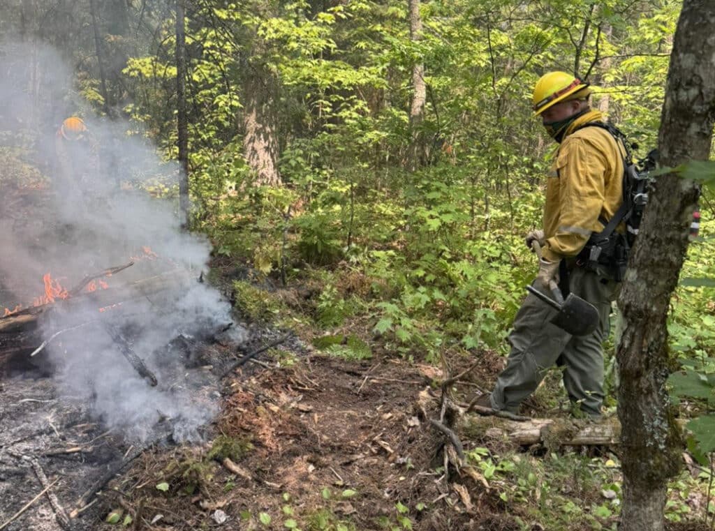
The July 28 update puts the combined incident at 64,054 US acres — essentially flat, reflecting improved mapping — plus 8,443 in Canada, with Little Knife holding at 4,958 acres. Camp jumped to 46% contained, up from 39%, while Sioux (27%), Little Knife (49%), Bear Trap (38%), Thumb (56%), and Chub (95%) held steady. Personnel eased to 999 on the broader incident even as Little Knife’s crew grew again, to 128. Overnight thunderstorms Sunday into Monday produced roughly 800 lightning flashes over the fire area, about 40% striking the ground, prompting extra patrols to catch any new starts; recent rain and moderate humidity are otherwise keeping fire behavior down, letting crews build containment lines and lay hose closer to the fires’ edges.
Evacuation zones continue to shrink toward the areas closest to the fires — mainly along the Echo Trail, the Cloquet Line, and a handful of BWCAW-adjacent zones in Lake County.
Trails End Campground reopens
A community meeting focused specifically on the Little Knife Fire is set for 7 p.m. Wednesday, July 29, at the Gunflint Volunteer Fire Department’s Fire Hall 1. Separately, the Forest Service announced it will lift the closure of Trails End Campground, at the end of the Gunflint Trail, on July 29 — the campground has been closed since July 15 due to wildfire activity, and officials say recent rain has moderated fire behavior with no recent spread near the site.
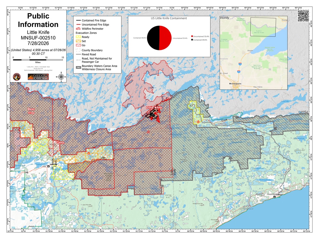
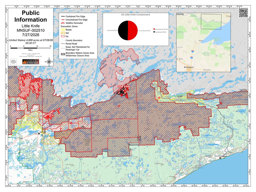
July 27 update:
Day use begins, Little Knife containment jumps to 49%
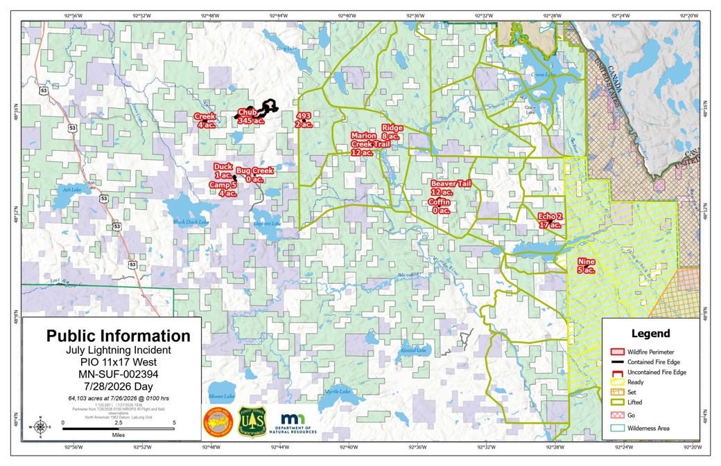
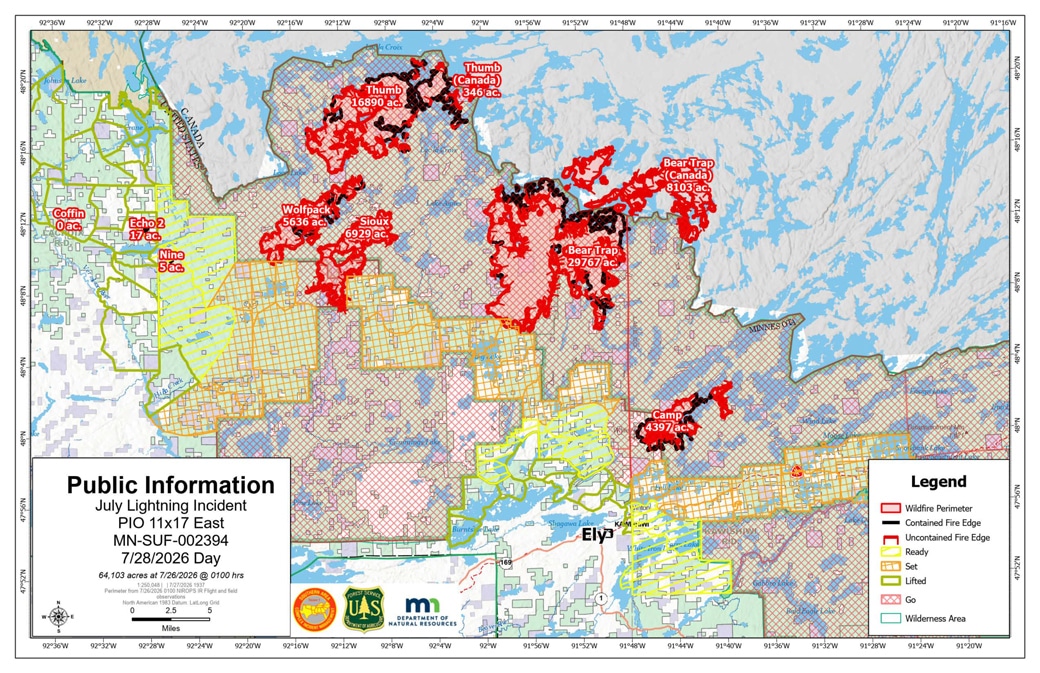
The combined incident held essentially steady at 64,103 US acres plus 8,443 in Canada, with Little Knife’s US footprint unchanged at 4,958 acres. Day-use access to select Gunflint and Tofte district entry points opened today under the Forest Service’s Phase 1 plan, with overnight permits still cancelled through Wednesday, July 29, and a Phase 2 decision on restoring overnight camping expected this week. Little Knife jumped to 49% contained, up from 38% Sunday, after a hotshot crew, 12 smokejumpers, and two specialized wildland fire modules worked its eastern and southwestern perimeters; a crew is also traveling by canoe to improve portages as control features between lakes. Personnel assigned to Little Knife grew to 125, even as total incident personnel dropped to 1,066 as crews demobilize from fires that have stabilized — the Thumb Fire, holding at 56% contained, goes unstaffed today after its hotshot crew left by watercraft over the weekend. Camp (39%), Sioux (27%), Bear Trap (38%), and Chub (95%) held steady overnight.
Evacuations downgraded across the region
Most evacuation zones came down a level Sunday evening, July 26. Most evacuation zones in St. Louis, Lake, and Cook counties came down a level Sunday evening, July 26, with GO zones generally moving to SET and SET zones to READY; a handful of zones closest to the fires, including along the Echo Trail and Cloquet Line, remain at GO. The Echo Trail will now close daily from 9:30 a.m. to 7 p.m. for firefighter and equipment safety. Counties’ address-searchable evacuation maps have the property-specific status.
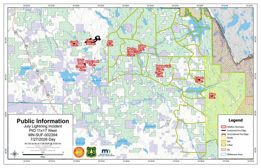
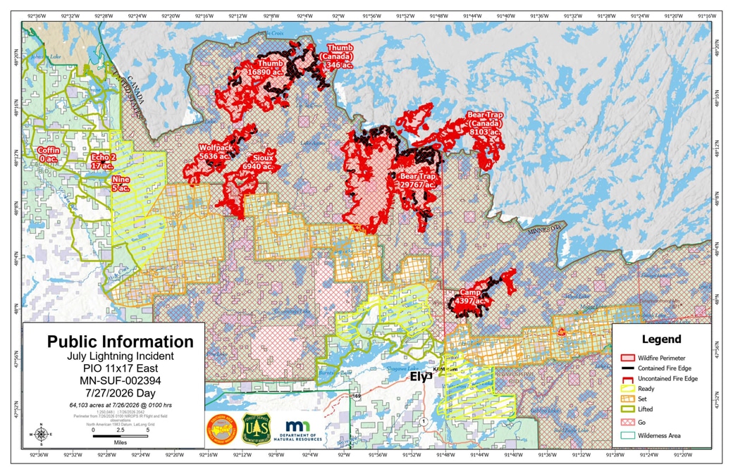
Community meeting tonight in Ely
Tonight’s community meeting on the July Lightning Incident is at 6 p.m. at the Ely Memorial High School Auditorium (600 E Harvey Street), with a live virtual option on the Superior National Forest Facebook Page.
July 26 update:
Containment climbs, personnel grows
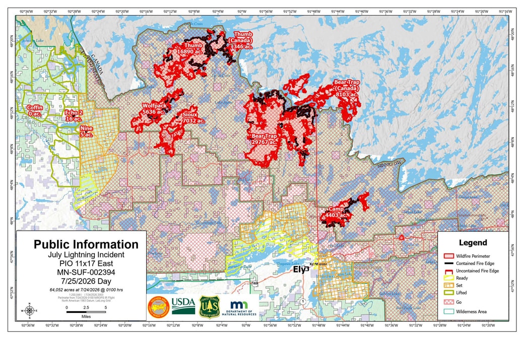
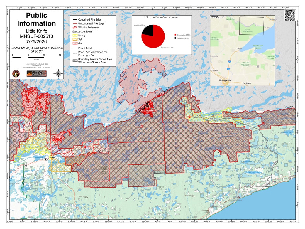
The July 26 daily update puts the combined incident at 64,156 acres in the United States plus 8,443 in Canada, with the Little Knife Fire’s US side estimated at 4,958 acres. Containment gained on two fires: Camp is now 39% contained (up from 23% Friday) at 4,407 acres, and Little Knife is 38% (up from 21%). Bear Trap holds at 38% (37,837 total acres, 29,767 US), Sioux at 27% (12,668 acres), Thumb at 56% (17,236 total, 16,890 US), and Chub at 95% (344 acres); the ten smaller fires west of Echo Lake remain fully contained at 64.4 combined acres. Personnel has grown to 1,274 on the July Lightning Incident and 87 on the Little Knife Fire.
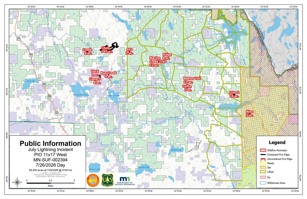
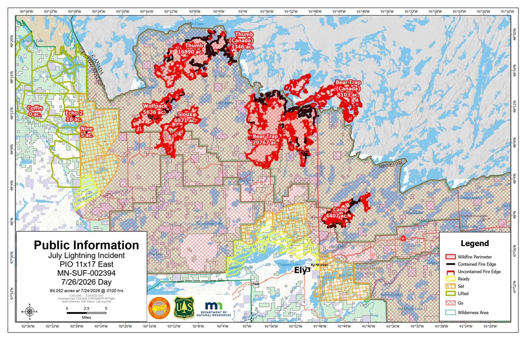
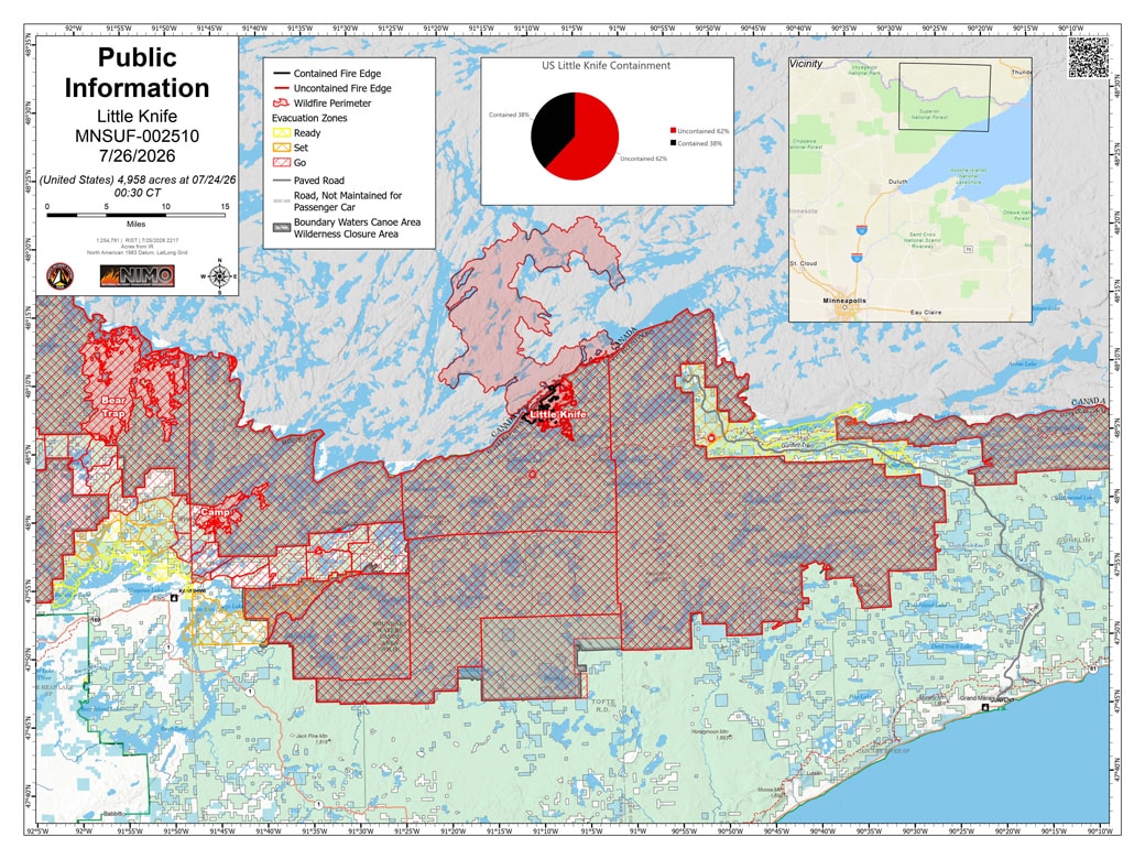
At the Little Knife Fire, a smokejumper module is being inserted into the BWCAW by canoe today to join a hotshot crew securing the fire’s eastern perimeter. At Bear Trap, crews are widening a fuel break north of the Echo Trail from 30 feet toward 100 feet and continuing to chip near structures at the Lodge of Whispering Pines. On the Thumb Fire, a hotshot crew is demobilizing by watercraft after completing its work on the line.
Warm, stormy day raises new-start risk
Today is expected to be the warmest of the next several days, with highs near or above 90 degrees and northwesterly winds gusting to 18 mph. The Forest Service says afternoon and evening thunderstorms are possible, some potentially severe with frequent lightning, brief downpours, large hail, and strong winds — raising the risk of new fire starts.
July 25 update:
Evacuation zones are being rolled back
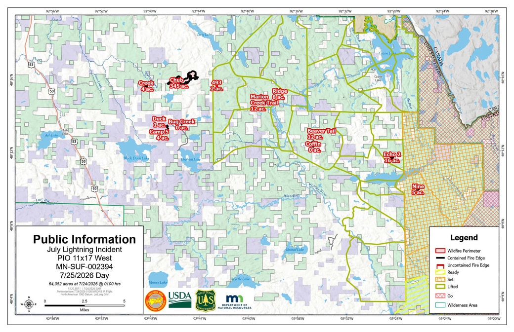
St. Louis County has completely lifted its READY and SET zones west of the Echo Trail and around Crane Lake, and Cook County lifted the READY status for the Schroeder, Tofte, and Lutsen districts on July 22 as fire behavior potential on the Little Knife Fire declined; the Gunflint Trail remains at SET and READY between Mid-trail and the trail’s end. In Lake County, the GO orders along the Fernberg remain — but property owners have begun limited, temporary escorted re-entries to check on their homes. Counties now offer an address-searchable evacuation map, linked from each county’s emergency management page.
Containment continues climbing
Bear Trap is 38% contained, Sioux 27%, Camp 23%, Thumb 56%, Little Knife 21%, and Chub 95%, with ten smaller fires fully contained at 64.4 combined acres. Personnel has grown to 1,148 on the July Lightning Incident plus 85 on Little Knife — the largest force yet. Overnight rain dropped 1 to 1.5 inches on the northwestern fire area, and a hotshot crew is being inserted into the wilderness at the Little Knife Fire, where initial work includes widening portages for safer crew access between lakes. The Long Lake Fire, now 15 acres, has come under the incident management team’s command, and the 614 and Little Lake fires have shifted to state DNR management. The Phase 2 reopening decision is expected Monday.
July 23 update:
For the first time, all of the major fires have containment lines on the books.
The Thumb Fire is 58% contained, Bear Trap 34%, Camp 23%, and Sioux 17%, according to the July 22 daily update. The eleven fires west of Echo Lake are 85% contained combined — nine are fully contained at just 62.5 acres total, and Chub is at 82.8%. Personnel on the incident has grown to 962, and additional crews are arriving at the Little Knife Fire to begin strategic suppression. Total acreage is steady at 63,594 US acres plus 8,412 in Canada, with Little Knife at 4,598.
The BWCAW closure order now formally runs through October 1, 2026, or until rescinded sooner. The change sets a season-long outer limit on the order rather than a prediction — the Forest Service continues to evaluate the closure daily and said Monday it is assessing opportunities to reduce it in areas that make sense, with permit holders notified seven days before their entry dates. Warmer, drier weather returns through the end of the week, and fire managers expect activity to pick back up as fuels dry.
The Forest Service announced the first partial reopening on July 23: day-use permits at select entry points open Monday, July 27, with overnight permits cancelled through July 29. Officials say select entry points could open to overnight use next week if there is no major fire activity this weekend. See our full story.
July 21 update:
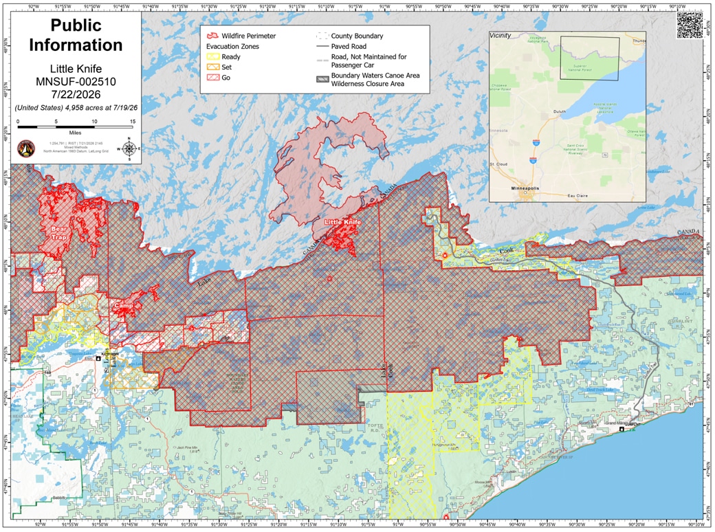
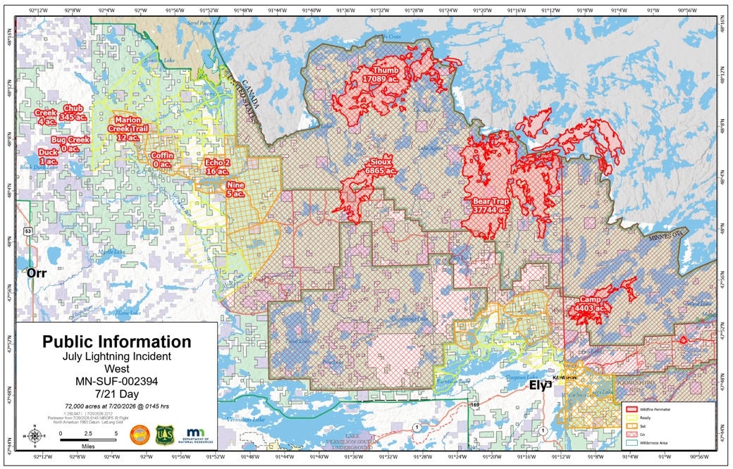
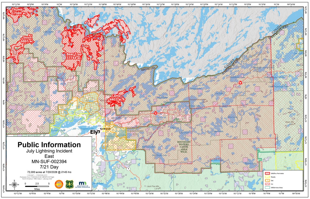
Containment is taking hold on the western fires: the eleven fires west of Echo Lake are now 57% contained combined, with nine — Echo 2, Beaver Tail, Ridge, Creek, Marion Creek Trail, Nine, Camp 5/Duck, Bug Creek, and Coffin — at 100%, according to the July 21 daily update. The Chub Fire is 50% contained at 348 acres. The larger fires held nearly steady: Camp at 4,402 acres, Sioux at 12,354, Bear Trap at 37,747 total (29,682 US), and Thumb at 17,088 total. The Little Knife Fire was refined downward again to 4,598 US acres, with minimal fire activity; a Chinook helicopter has been dropping water on hot spots. Cool, cloudy weather — highs only in the 60s — is helping, though fire managers warn that drying winds could reveal holdover lightning fires from the weekend’s storms.
July 20 update:
Better mapping revises acreage downward
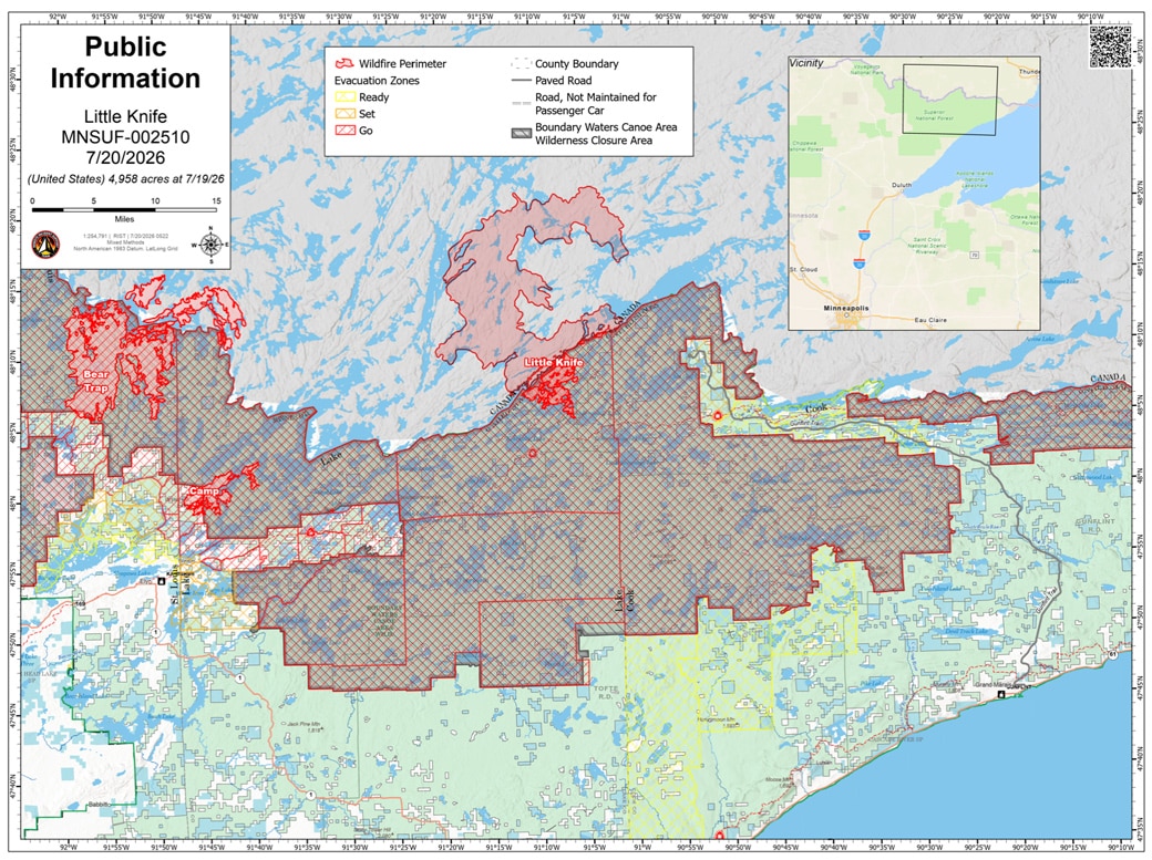
The official acreage was revised downward as clearing smoke allowed accurate infrared mapping: the July 20 daily update puts the July Lightning Incident at 63,117 acres in the United States plus 8,401 in Canada, with the Little Knife Fire’s US side refined to 4,958 acres — a US-side total of roughly 68,000, down from last week’s estimate of 77,000. No fires shrank; the mapping improved.
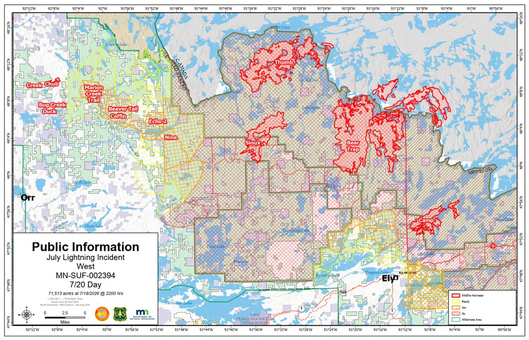
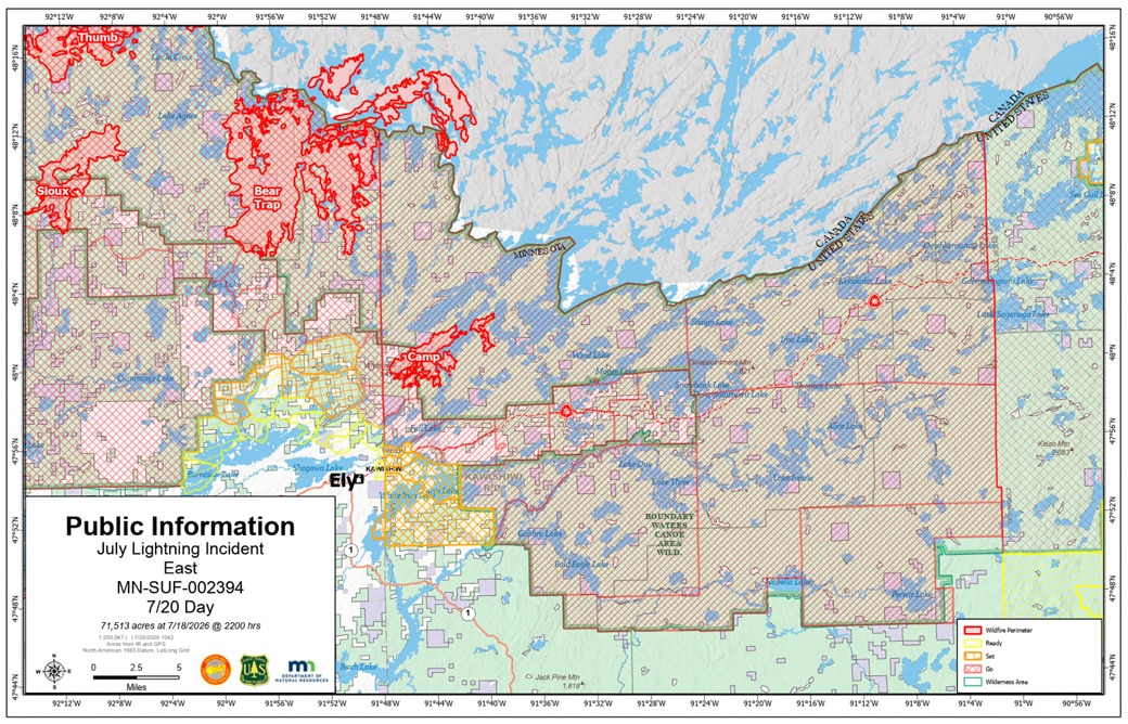
Individual fires now stand at approximately: Bear Trap 37,623 total acres (29,556 US), Thumb 16,812 (16,478 US), Sioux 12,295, Camp 4,374, and Chub 348. The ten fires west of Echo Lake are 30% contained combined, with several — Marion Creek Trail, Bug Creek, Coffin, and Duck — at 100%. Three new starts were caught small, including the Long Lake Fire (5 acres) and 493 Fire (1 acre); 780 personnel are now assigned.
Officials weigh reducing the BWCA closure; holding the Echo Trail line
At a Monday briefing, officials said for the first time that they are assessing opportunities to reduce the BWCAW closure “in areas that make sense,” with no timeline, and with Friday’s permit-cancellation date serving as a natural decision point. Operations chief Shane Greer of the Southern Area Complex Incident Management Team described the strategy plainly: hold the fires north of the Echo Trail — one slop-over south of the road is lined and holding — while structure protection works south toward populated communities and crews monitor critical infrastructure, including Highway 1 and the power supply. Across all jurisdictions, including state-managed fires not counted in the federal incident, Greer estimated roughly 25 fires on the landscape, a number that could reach 30. The Forest Service acknowledged that vehicles remain at some entry point parking lots — law enforcement is identifying the owners — and that some frustrated visitors are testing the closure boundaries; area outfitters report no clients remaining in the wilderness.
Clearer air, calmer weather, and a community meeting Tuesday
Cooler, calmer weather is expected through midweek, though winds gusted to 35 mph Monday and roughly 60 lightning strikes hit the fire area overnight Sunday. Smoke conditions have improved markedly, with better air quality expected for several days; N95 masks and box-fan filter kits are available at the State Theater in Ely. A community meeting on the eastern-BWCAW fire will be held Tuesday, July 21 at 7 p.m. at the Lutsen Town Hall (116 Caribou Trail), livestreamed on the Superior National Forest Facebook page.

July 19 update:
The first quiet day
Fire activity was minimal on the Camp, Sioux, and Bear Trap fires Saturday, and an overnight infrared flight revised the July Lightning Incident’s total down to just under 69,000 acres, plus about 6,000 US-side acres on the Little Knife Fire. The ten fires west of Echo Lake are now 13% contained combined, with several in patrol status. Crews used the pause to extend handlines and structure protection — including around Whispering Pines and Big Lake Lodge on Big Lake — and have begun widening the Echo Trail eastward as a containment line connecting toward the Camp Fire.
Evacuation notices shifted July 18: St. Louis County expanded GO status in additional areas near the Echo Trail and issued a READY notice for the City of Winton area north of Burntside Lake. Permit holders now get notifications seven days before their entry date, up from four, and a dedicated Recreation.gov permit line is available at 218-626-4314. The reprieve may be brief — highs return to the high 80s and low 90s with a 50% chance of afternoon thunderstorms, and Sunday evening storms could bring small hail, erratic winds, and frequent lightning, raising the risk of new starts.

July 18 update:
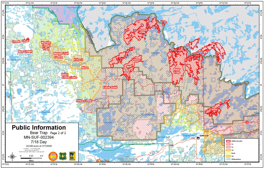
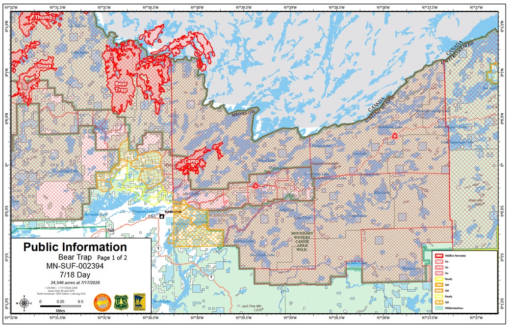
A new command team is in charge, and the fires are finally fully mapped. The Southern Area Complex Incident Management Team assumed command of all 15 wildfires Saturday, and with Friday’s clearing smoke, remapping put the July Lightning Incident at just over 71,000 acres, plus 6,000 US-side acres on the Little Knife Fire. Several fires were revised sharply upward: Bear Trap to approximately 34,545 acres, Sioux to 10,837, and Thumb to 15,394 — and the Little Knife Fire has burned approximately 80,000 acres in Canada.
Crews are focused on structure protection, installing hoses and sprinklers around homes on Big Lake and evaluating the Echo Trail as a containment line to keep the Bear Trap Fire from moving south; the Sioux Fire has crossed the Echo Trail, where crews are building handline. The Forest Service also extended BWCAW permit cancellations through Friday, July 24, giving visitors and outfitters more reliable planning time. Friday’s rain — a half inch to an inch — is expected to be only a temporary pause, with hot, dry weather returning this weekend.
July 17 update:
At a briefing Friday, officials estimated the fires have burned approximately 77,000 acres so far, MPR News reported — and the focus has turned to Big Lake, about 15 miles up the Echo Trail northwest of Ely, where the Bear Trap Fire is roughly a mile from resorts, homes, and cabins. “We are still very extreme here,” said Jason Loomis, the National Incident Management Organization incident commander now overseeing the five largest fires. Officials called the conditions unprecedented for northern Minnesota and reiterated the firefight may last until snow.

Firefighter numbers are over 600, up from 400–500 a day earlier, according to the Minnesota DNR, with four Minnesota National Guard helicopters and a State Patrol helicopter supporting crews, and Hotshot crews from New Mexico and Mississippi available if conditions worsen. The wilderness sweep has covered about 90% of the BWCAW; the Forest Service was still tracking one group making its way out and expects three to four more days to finish. Crews are also working to keep smaller fires away from Crane Lake and its single access road.
The rain arrived — with a catch. Thunderstorms moving through the area Friday morning brought approximately 13,000 lightning strikes, according to the Forest Service’s July 17 fact sheet, and the agency says new fires may be detected as the sun comes out. Rain totals of a quarter to a half inch were expected, with erratic shifting winds and the potential for isolated damaging gusts; before the rain, crews watched as many as five trees fall across the Echo Trail in a half hour.
Fires are pressing on the Echo Trail from both sides
The Sioux Fire, at approximately 7,368 acres, has crossed the Echo Trail near the Little Indian Sioux River, with firefighters protecting structures including the Meander Lake communication site. The Bear Trap Fire, holding at about 13,500 acres, has pushed to within a half mile of the Echo Trail. Heavy smoke continues to hamper aerial mapping, so acreage estimates for several fires — including the Camp and Little Knife fires — remain unchanged from earlier reports.
The forest counts 16 active wildfires, three inside the BWCAW. The Crescent Fire near Tofte is contained at a half acre.

July 16 update:
The fires now cover approximately 55,000 acres on the US side alone and officials say fire will be on this landscape until the snow falls.
Evacuation preparedness has expanded toward the North Shore. Cook County has moved parts of the Gunflint Trail west of Hungry Jack Lake Road and the northern parts of the townships of Schroeder, Tofte, and Lutsen into READY status, according to the Forest Service’s July 16 fact sheet; the end of the Gunflint Trail remains at SET due to the Little Knife Fire.
The Sioux Fire has grown to approximately 7,368 acres and portions of it are now burning inside the BWCAW, with extreme fire behavior. The Camp Fire is shown at 4,176 acres on the July 16 public information map, though the day’s fact sheet still lists 2,886 while noting continued growth overnight. The Thumb Fire was remapped at 14,129 acres. Note that the day’s map and fact sheet diverge on several fires — the map shows Bear Trap at 34,422 acres, apparently including its Canadian extent, versus 13,500 in the fact sheet — so figures here are attributed to their source and may be revised as smoke allows better mapping. Cloud cover, lighter winds, and higher humidity moderated fire growth Tuesday — though dense smoke kept aircraft largely grounded — and there is finally rain in the forecast: a 30% chance Thursday afternoon, rising to 80% Friday. An Air Quality Alert continues through Friday.
The Forest Service asks recreational boaters and shoreline property owners to stay on shore where aircraft are scooping water — watercraft idling in wide bays force emergency aircraft to abort their missions. Among the newer fires, the 1-acre Crescent Fire near Tofte was human-caused, the event’s first; the Birch Island, Buck, and South Shore Drive fires are in patrol status.

The Forest Service has temporarily closed all BWCAW entry points effective 12:01 am Tuesday, July 14.
Read the full story.
July 15 update:
Fire crosses the border into the eastern BWCAW
A fire from Ontario has crossed into the eastern BWCAW at Monument Portage. The Little Knife Fire is estimated at 6,000 acres on the US side of a 30,000-acre fire, with mapped growth as far south as Ogishkemuncie Lake; Trails End Campground is closed, and Cook County’s Ready-Set-Go notice for the northern Gunflint Trail remains in effect. Read our full story.
Fires merge and evacuations expand west of Ely
The Wolfpack and Sioux fires have merged — now called the Sioux Fire, at approximately 6,922 acres — and St. Louis County has issued a GO evacuation order for portions of the Echo Trail from Big Lake to the 200 Road. The Fernberg corridor GO order continues. Both the Fernberg (Lake County Highway 16, east of Ely) and the Echo Trail are closed to travel, officials said at Wednesday’s briefing, and the closures will change as the fires move. The Thumb Fire is approximately 14,500 acres and the Bear Trap Fire approximately 13,500; both have crossed into Canada. The Camp Fire is 2,886 acres with continued extreme behavior, and the Chub Fire, at 317 acres, is the largest of the MNICS-managed fires. The forest counts 15 active wildfires, four inside the BWCAW, and says it has not experienced such widespread extreme fire conditions in over 20 years.
Wilderness sweeps and air rescues
At a press briefing Wednesday in Ely, officials said forest staff sweeping the wilderness by canoe have reached an estimated 90 percent of visitors, and confirmed 17 air rescues on Monday. About 500 personnel are assigned, and northeastern Minnesota is now the country’s number three firefighting priority.
Fire management officer Nick Petrack said the fires are burning up to two to three feet into the ground: “We will be in this until fall.” BWCAW permits are being evaluated daily, with permit holders notified four days before their entry date; a permittee information line is available at 218-235-4400 or 218-235-3113.
State response
Gov. Tim Walz declared a peacetime emergency for the wildfires on July 12 (Executive Order 26-08), mobilizing the Minnesota National Guard to assist with the response. On Wednesday, the state Executive Council voted to extend the emergency by 30 days. The Red Cross has opened a temporary evacuation center at the Babbitt Municipal Building, about 20 minutes south of Ely, open 8 am to 9 pm.

Smoke fills the air
An Air Quality Alert runs through Thursday, with “Very Unhealthy” smoke settling over Ely and communities east in the evenings, and poor visibility is limiting firefighting aircraft. MPR News reported a new state record for wildfire smoke concentration near Duluth. Cooler temperatures and a slight chance of rain are forecast — a “momentary pause,” in the meteorologist’s words, not a change.
Fire information lines:
218-881-2091 (8 am-8 pm) | BWCAW permittees: 218-235-4400 or 218-235-3113

July 14 update:
Wildfires burn more than 33,000 acres in the Superior National Forest and BWCA
Extreme fire conditions Monday drove explosive growth across the forest, and two wilderness fires have crossed the international border into Canada, according to the Forest Service and MNICS.
The merged Dark/Bear Trap Fire — now officially the Bear Trap Fire — is approximately 12,896 acres, south of Lac La Croix about 20 miles north of Ely, with extreme fire behavior including crowning, torching, and spotting. The Thumb Fire is approximately 12,327 acres, about 6 miles south of the Gakijiwanong Anishnaabe Nation in Canada. Both crossed the border Monday; the forest is coordinating with Canadian authorities, and aircraft are suppressing both fires on the US side. The Wolfpack Fire has grown to approximately 2,234 acres.
Outside the wilderness, the Sioux Fire is approximately 3,516 acres with wind-driven spotting, and firefighters are conducting structure protection there and on the 2,200-acre Camp Fire, where a GO evacuation order is in effect for the Highway 16/Fernberg corridor from the Garden Lake Bridge to Lake One, with a shelter at the Babbitt Municipal Building. Evacuation statuses are in effect in all three forest counties. Two new fires were reported: the Birch Island Fire (0.25 acre, Snowbank Lake) and the Buck Fire (1 acre, east of Trout Lake), both under investigation. The Echo 2 Fire, previously declared contained, is now 14 acres after crossing its control lines multiple times. The forest counts 17 active wildfires, three inside the BWCAW.
An Air Quality Alert is in effect Tuesday through Thursday, with heavy smoke rated “Very Unhealthy” expected to settle over Ely and communities east across the forest in the evenings. A Red Flag Warning and Extreme Heat Warning continue. The Forest Service says a press briefing will be held at 1 p.m. Wednesday in Ely.


July 13 update:
Camp Fire escapes containment and is rapidly growing. The Camp Fire northeast of Ely — declared 100% contained just a day earlier — jumped its containment lines Monday afternoon, prompting evacuation orders along the Cloquet Line. By Monday evening, Watch Duty and the Ely Echo reported the fire at approximately 1,500 acres.
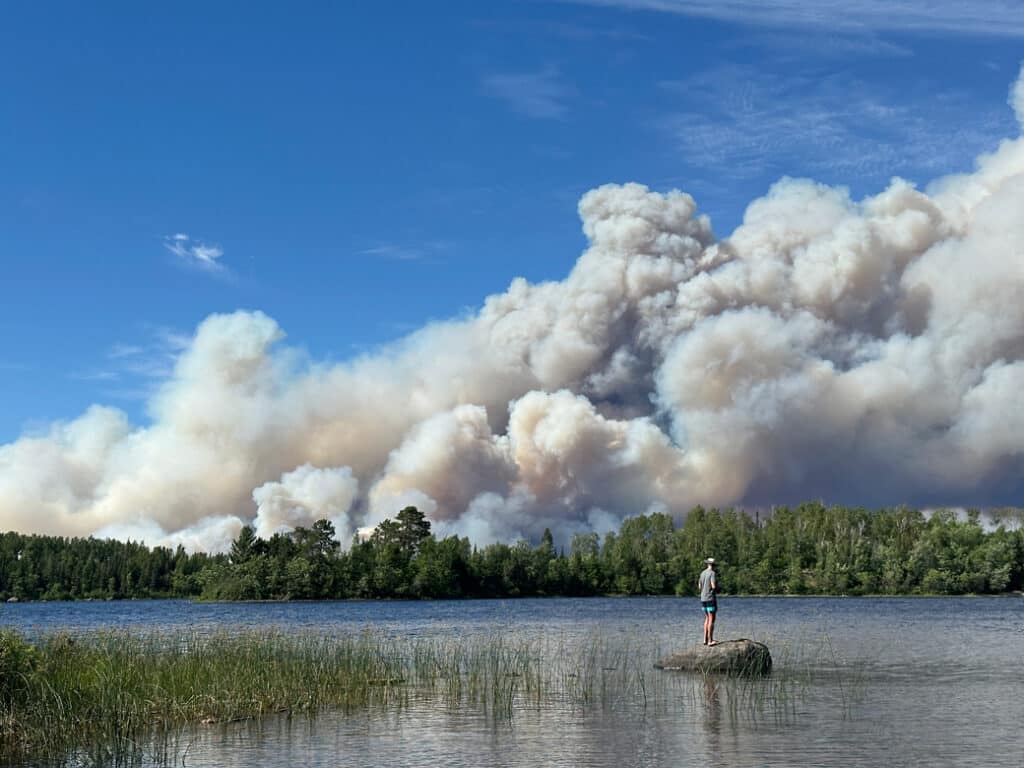
The Thumb Fire has grown to approximately 6,500 acres — a more than tenfold increase from Sunday — and the combined Dark Fire/Bear Trap Fire, south of Lac La Croix, is now approximately 2,000 acres with very active fire behavior, according to the Forest Service’s July 13 fact sheet. Aircraft are dropping water on both. The Wolfpack Fire is holding at about 80 acres, and the Sioux Fire, still burning toward the BWCAW, is approximately 300 acres. The forest reports 16 active wildfires — four inside the BWCAW — out of 20 total from the lightning event.
Evacuation preparedness has expanded. St. Louis County has READY and SET notices in areas around the Sioux Fire and the Marion Creek, Ridge, Beaver Tail, Coffin, and Echo 2 fires; residents can register for alerts through the county’s Everbridge system and monitor the sheriff’s wildfire page. Cook County has issued a READY notice for a northern portion of the Gunflint Trail area due to Ontario’s FOR028 wildfire; see the county’s Ready-Set-Go map.
Fire managers anticipate another very high fire danger day, with an Extreme Heat Warning, Red Flag Warning, and Fire Weather Watch all in effect — highs near 97 with gusts to 25 mph. Smoke columns are visible from nearby communities; Ontario fire information is available on the province’s interactive fire map.


Update: July 12, 2026 8:00 pm
Sunday’s heat and wind drove significant fire growth, according to the Forest Service. St. Louis County has raised its Ready-Set-Go evacuation status to SET for the Sioux Fire, which grew from 59 to 288 acres and is burning toward the BWCAW; the Forest Service is removing vehicles from the Little Indian Sioux North entry point (#14) parking lot. Residents can monitor the St. Louis County Sheriff’s wildfire page for evacuation information.
In the wilderness, the new Dark Fire, east of Dark Lake and south of Lac La Croix, merged with the Bear Trap Fire on Sunday afternoon — a combined 700 acres, burning toward Crooked Lake with very active fire behavior. The Thumb Fire is now 600 acres and the Wolfpack Fire 80 acres; aircraft are working all three. The forest reports 20 active wildfires, five inside the BWCAW.
The Camp, Fools Gold, Section 3 Pond, and Long 2 fires are contained and received their final reports. Monday’s forecast — a high of 100, gusts to 25 mph, an Extreme Heat Warning through July 14 — offers no relief.

Update: July 12, 2026 2:00 pm
The wilderness fires grew overnight amid hot, dry, windy conditions, according to the Forest Service’s July 12 fact sheet. The Thumb Fire is now 500 acres — up from 143 on July 11 — and the Bear Trap Fire has grown from 4 acres to 85. The Wolfpack Fire, southeast of Wolfpack Lake, is 61 acres. All three are in remote areas of the BWCAW with difficult access, with aircraft conducting water drops. Outside the wilderness, the Sioux Fire has grown to 59 acres and is active with wind-driven spotting.
A Red Flag Warning is in effect, with an Extreme Heat Warning and Fire Weather Watch through Tuesday. The Forest Service says increased temperatures, winds, lower humidity, and lack of recent precipitation are increasing fire behavior on some fires.
The forest reports 16 active wildfires, four inside the BWCAW. A Minnesota Incident Command System (MNICS) team under Incident Commander Mike Hill took command of ten of the fires on July 12: Creek, Chub, Camp 5/Duck, Coffin, Bug Creek, Ridge, Marion Creek, Beaver Tail, Echo 2, and Nine. In its first daily update, the team said firefighter and public safety are the highest priorities under Red Flag conditions, with a full suppression strategy used where conditions allow.
St. Louis County has implemented its Ready. Set. Go. evacuation notification system. No evacuations have been announced; residents are asked to monitor the county’s official channels for current information at the St. Louis County Sheriff’s wildfire page and can sign up for alerts through Northland Alert.
Status of the fires managed by Superior National Forest, as of the July 12 fact sheet:
In the BWCAW:
- Thumb Fire — 500 acres, between Thumb and Contentment lakes; aircraft dropping water; caused by lightning
- Bear Trap Fire — 85 acres, off the Bear Trap River, north of Sunday Lake; aircraft dropping water; caused by lightning
- Wolfpack Fire — 61 acres, southeast of Wolfpack Lake; remote; suppression underway
- Section 3 Pond Fire — 2.3 acres, on Section Pond, east of Lac La Croix; 100% contained, checked daily
Outside the BWCAW:
- Sioux Fire — 59 acres, north of the Echo Trail, east of Jeanette Campground; active with wind-driven spotting
- Rabbitt Fire — 12 acres, south of Ray in Koochiching State Forest
- 614 Fire — 7.3 acres, northwest of Ash Lake; about 50% contained
- Fools Gold Fire — 2.1 acres, west of Norway Road, south of Lake Jeanette; 60% contained
- Camp Fire — 1 acre, near Ely; now 100% contained
MNICS-managed fires:
- Beaver Tail Fire — 10 acres, west of the Vermilion River; dozer line around the entire perimeter, hose lines going in
- Chub Fire — 50 acres, north of Chub Lake, southwest of Crane Lake; active fire behavior; dozer and hose lines being extended
- Ridge Fire — 8 acres, east of the Vermilion River; active fire behavior; aircraft water drops, dozer line on the northern perimeter
- Creek Fire — 3.5 acres, northwest of Chub Lake; hose line around the perimeter, mop-up beginning
- Marion Creek Fire — 2 acres, west of the Vermilion River; minimal fire activity
- Nine Fire — 5 acres, south of Echo Lake; dozer, hand, and hose lines around the perimeter
- Echo 2 Fire — 0.1 acre, off Echo Rapids Road; firefighters patrolling for remaining heat
- Camp 5/Duck Fire — 1 acre, north of Elephant Lake; minimal activity, daily aerial monitoring
- Bug Creek Fire — 0.1 acre, south of Chub Lake; little to no activity, daily aerial monitoring
- Coffin Fire — 0.1 acre, northwest of Echo Lake; likely a duplicate fire, daily aerial monitoring
The Long 2 Fire remains 80% contained. The Newton Fire, declared controlled and contained July 11, is no longer listed in the daily fact sheet.
Phone information line:
The Forest Service has opened a dedicated fire information line for the July lightning event: 218-881-2091, staffed 8:00 am – 8:00 pm, or by email at 2026.JulyLightningEvent@firenet.gov.

July 11 update:
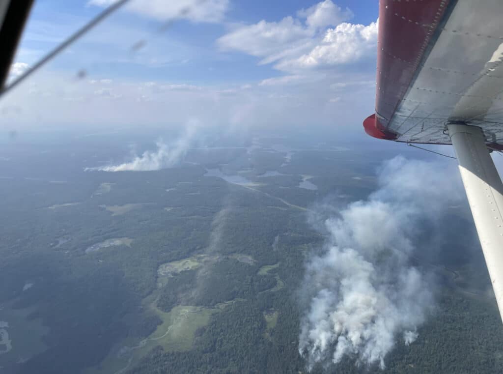
The Thumb Fire has grown to 143 acres, by far the largest of the wildfires burning on the Superior National Forest, according to the Forest Service’s July 11 fact sheet. The fire is in remote country between Thumb and Contentment lakes in the BWCAW, with difficult access; US and Canadian aircraft are conducting water drops.
The forest reports 17 active wildfires, four inside the BWCAW. A new fire, the Rabbitt Fire, was reported July 10 south of Ray in Koochiching State Forest, and the Coffin Fire has been removed from the list — a duplicate the agency was unable to locate on the landscape. Effective July 12, the Minnesota Incident Command System (MNICS) will take command of nine of the fires: Creek, Chub, Camp 5/Duck, Bug Creek, Ridge, Marion Creek, Beaver Tail, Echo 2, and Nine.
Firefighters have been making good progress, the agency says, and conditions are a concern: a heat advisory was in effect July 11, and an extreme heat watch is in effect Sunday, July 12, with a forecast high near 98 and southwest gusts to 25 mph.
Fire status as of the July 11 fact sheet (2:00 pm):
In the BWCAW:
- Thumb Fire — 143 acres, between Thumb and Contentment lakes; US and Canadian aircraft conducting water drops; caused by lightning
- Wolfpack Fire — 5 acres, southeast of Wolfpack Lake; remote; suppression underway
- Bear Trap Fire — 4 acres, off the Bear Trap River, north of Sunday Lake; minimal fire activity; aircraft dropping water; caused by lightning
- Section 3 Pond Fire — 2.3 acres, on Section Pond, east of Lac La Croix; 100% contained, crews demobilizing

Outside the BWCAW:
- Chub Fire — 25 acres, north of Chub Lake, southwest of Crane Lake; dozer line being built around the fire
- Beaver Tail Fire — 10 acres, west of the Vermilion River, in blowdown and dead balsam; hose line in place, aircraft assisting
- 614 Fire — 7.3 acres, northwest of Ash Lake, east of Highway 53; about 50% contained, perimeter hose line in place
- Sioux Fire — 6.5 acres, north of the Echo Trail, east of Jeanette Campground; direct suppression, working toward containment
- Ridge Fire — 6 acres, east of the Vermilion River; 75% contained, dozer working from the north
- Nine Fire — 5.4 acres, south of Echo Lake; dozer line around the fire, with indirect confinement firing on unburned pockets
- Rabbitt Fire — 3 acres, south of Ray in Koochiching State Forest; reported July 10
- Creek Fire — 3 acres, northwest of Chub Lake
- Fools Gold Fire — 2.1 acres, west of Norway Road, south of Lake Jeanette; 60% contained
- Camp Fire — 1 acre, 8 miles north/northeast of the Cloquet Line near Ely; 80% contained
- Echo 2 Fire — 0.25 acre, off Echo Rapids Road; 100% contained
- Marion Creek Fire — 0.1 acre, west of the Vermilion River; minimal fire activity
- Bug Creek Fire — 0.1 acre, south of Chub Lake; minimal fire activity
- Camp 5/Duck Fire — 0.1 acre, north of Elephant Lake; little to no fire activity, routine aerial checks
- Newton Fire (BWCAW) — controlled and contained

Get Fire Updates
Stay informed on recent wildfires, campfire bans, park closures, straight to your inbox.
July 10 update:
The Forest Service has issued an emergency closure order for three wildfire areas in the BWCAW and campfire restrictions within the wilderness, both effective July 11. See details here.
InciWeb is now tracking the fires as a single incident, “July 2026 Superior NF Wildfires.” As of Friday afternoon, it listed 17 active wildfires on the forest, four inside the BWCAW, with nine new fires reported July 9. A storm system moved through the area on the evening of July 6 with thunder, lightning, and little precipitation, and with warm, dry conditions, additional wildfires are being detected daily.
Fire details below are from InciWeb, current as of Friday afternoon. Firefighters are assessing conditions, working on access, and developing suppression plans for the new fires.
New fires reported July 8–9:
- Chub Fire — 10 acres, north of Chub Lake, southwest of Crane Lake
- 614 Fire — 7.3 acres, northwest of Ash Lake, east of Highway 53
- Sioux Fire — 6 acres, north of the Echo Trail, east of Jeanette Campground
- Ridge/Marion Creek Fire — 4.5 acres, east of the Vermilion River
- Nine Fire — 4 acres, south of Echo Lake
- Wolfpack Fire (BWCAW) — 2 acres, southeast of Wolfpack Lake
- Creek Fire — 1.5 acres, northwest of Chub Lake
- Beaver Tail Fire — 1 acre, west of the Vermilion River
- Bug Creek Fire — 0.1 acre, south of Chub Lake
- Camp 5/Duck Fire — 0.1 acre, north of Elephant Lake
- Coffin Fire — 0.1 acre, northwest of Echo Lake
Fires reported July 7–8:
- Thumb Fire (BWCAW) — 20 acres, between Thumb and Contentment lakes; aircraft conducting water drops
- Bear Trap Fire (BWCAW) — 2 acres, off the Bear Trap River, north of Sunday Lake; aircraft conducting water drops
- Section 3 Pond Fire (BWCAW) — 2 acres, on Section Pond, east of Lac La Croix; 100% contained
- Newton Fire (BWCAW) — 0.25 acre, west of Newton Lake; controlled and contained
- Fools Gold Fire — 1.5 acres, west of Norway Road, south of Lake Jeanette; 15% contained
- Camp Fire — 1 acre, 8 miles north/northeast of the Cloquet Line near Ely; 80% contained, mop-up underway
- Echo 2 Fire — 0.25 acre, off Echo Rapids Road, north of Echo Lake; 100% contained
Fish and Wildlife Service and Minnesota DNR are assisting with suppression on the forest; Quetico Provincial Park and Ontario also have numerous fires.
July 9 Update:
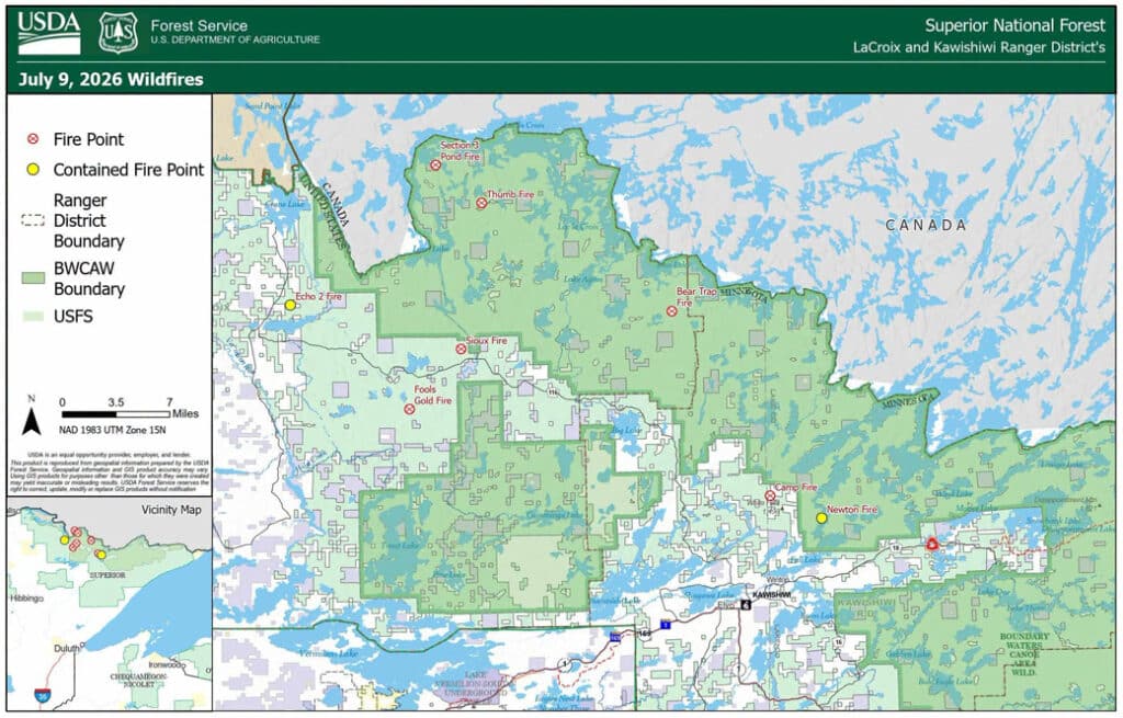
The U.S. Forest Service announced several new wildfires in the Superior National Forest on July 8, most of them inside the Boundary Waters Canoe Area Wilderness (BWCAW). The agency attributes at least three of the fires to lightning strikes; the causes of the others are listed as unknown or have not been reported.
The fires
Camp Fire (outside BWCAW) — 2 acres, approximately 8 miles north/northeast of Ely, burning in heavy timber with pockets of blowdown. Fire activity was creeping and smoldering, and two single-engine aircraft made multiple water drops to slow the spread. Three firefighters have worked their way into the fire, with more preparing to join them for full suppression. 0% contained.
Bear Trap Fire (BWCAW) — one-tenth of an acre, along the Bear Trap River north of Sunday Lake, in a remote primitive management area with very difficult access. Reported as a single-tree lightning strike with wispy smoke and minimal fire activity. Firefighters are assessing access and suppression options. 0% contained.
Thumb Fire (BWCAW) — one-tenth of an acre, by Thumb and Contentment lakes south of Lac La Croix, with difficult access. Reported as a single-tree lightning strike with minimal fire activity. Firefighters are strategizing access and suppression. 0% contained.
Section 3 Pond Fire (BWCAW) — three-quarters of an acre, on Section Pond east of Lac La Croix, just south of the Canadian border. Fire activity was reported as minimal; two firefighters are on scene using direct extinguishment, with two more joining them. 0% contained.
Newton Fire (BWCAW) — approximately one-quarter of an acre, west of Newton Lake near Jackfish Bay. Reported as a single-tree lightning strike; two firefighters are conducting direct suppression. 0% contained.
Echo 2 Fire — reported at 0.10 acre, located by aerial detection on July 8 on the LaCroix Ranger District. 100% contained as of July 9; firefighters will continue mop-up and cooling hot spots.
Fools Gold Fire — 1 acre, spotted by aerial detection on the afternoon of July 8. Firefighters and resources are on scene conducting suppression operations. 0% contained.
Causes
The Forest Service attributes the Bear Trap, Thumb, and Newton fires to lightning — each was reported as a single-tree lightning strike. The agency lists the causes of the Camp and Section 3 Pond fires as unknown; InciWeb also lists the Fools Gold Fire’s cause as unknown, and no cause has been listed for the Echo 2 Fire.
Closures
According to the Forest Service, there are currently no fire closures within the BWCAW, but the public is asked to stay out of the fire areas for their own safety and that of firefighters. The agency notes that unauthorized drone flights threaten firefighter safety and suppression efforts, are not allowed near the fire areas, and are illegal in federally designated wilderness.
Suppression efforts
According to the July 8 release, suppression in the BWCAW will use minimum-impact tactics whenever possible, with firefighters using natural features such as lowlands and shorelines for containment lines, hand tools, and water bags to cool hot spots when conditions allow.
Acreage figures reflect current estimates and may change as crews assess the fires. No information on evacuations was included in these reports.
We will update this story as the Forest Service releases new information.

More information:
- Superior National Forest Fire Information (USDA Forest Service)
- Superior National Forest Incident Information (USDA Forest Service)
- InciWeb Incident Page
- Superior National Forest Facebook Page
- Northern News Now: UPDATE: Seven wildfires reported in Superior National Forest
- WTIP: Firefighters continue suppression efforts on seven Superior National Forest wildfires