

“Hey, I finally have a signal,” I texted a friend from a pull-off along a forest road deep in the Superior National Forest. “Are you still up for a hike?”
I’d been looking forward to catching up with a good friend from Duluth all weekend. I generally try to avoid traveling between the Twin Cities and northeast Minnesota on weekends, but with this summer’s endless big projects, I needed to get home and back to work. While I find weekend traffic unnecessarily stressful, I was ecstatic to be traveling on the weekend so I could catch up with my friend.
He was ready and already had the hike planned. “This is the newest section of the Western Waterfront Trail,” he texted back with the coordinates.
“Oh. Thank you,” I replied. “I’ve always wanted to check out that trail. I should be there in two hours.”
Hiking Northeast Minnesota
I have hiked nearly every mile of trail in every Minnesota state park. Additionally, I’ve hiked nearly every trail in the Superior National Forest and a good portion of the Boundary Waters Canoe Area Wilderness (BWCAW). I’ve even thru-hiked the Superior Hiking Trail (SHT). All this considered, I find it amazing that I still have a growing list of trails in northeast Minnesota I want to hike. And of these trails, Waabizheshikana (waa-bah-zhay-shay-kuh-nuh)—The Marten Trail, also known as the Western Waterfront Trail—was at the top of my list.
The magnificent St. Louis River Estuary
As a Minnesota native, I have a deep appreciation for natural lakes. From Lake Superior to BWCAW hidden gems, northeast Minnesota lakes are my happy place. But then I discovered estuaries, and my appreciation of rivers and how they contribute to a healthy and thriving planet became a bit of an obsession. It wasn’t long after I began learning about estuaries that I discovered that one of the world’s largest freshwater estuaries starts right here in my home state, 13 miles east of Hoyt Lakes.
A traditional estuary is where freshwater from rivers mixes with saltwater from the ocean. Estuaries are home to unique animal and plant communities that have adapted to brackish water. You probably haven’t considered this while looking out over the Mississippi River in Minneapolis or St. Paul, but the health of the Mississippi, way up north here in Minnesota, affects the health of these communities way down south in the Gulf of Mexico.
Freshwater estuaries are unique ecosystems where a river meets a large freshwater lake, combining the unique physical and chemical characteristics of countless sources of freshwater. Consider this the next time you’re recreating in the Laurentian District of the Superior National Forest. The seemingly innocent act of bathing, washing dishes, or disposing of live bait in one of these waterways could affect life in Lake Superior over 190 miles away.
A great way to visualize the vastness of the St. Louis River is by hiking to the top of Ely’s Peak, where you’ll find unobscured overlooks of the vast waterways. Then I recommend hitting The Marten Trail to get up close and personal and experience just how massive this waterway actually is.
A work in progress
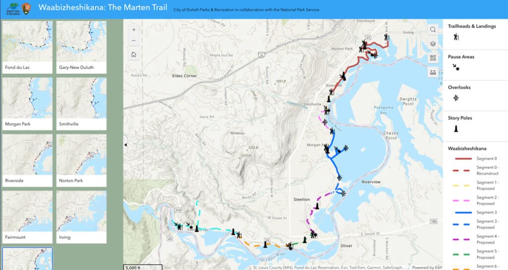
Commonly referred to as The Western Waterfront Trail, the trail was renamed in 2019 to Waabizheshikana (waa-bah-zhay-shay-kuh-nuh) or The Marten Trail in honor of the Marten Clan that settled in this part of the St. Louis River. The completion of the trail is an ongoing project that will eventually connect the Irving Park neighborhood in West Duluth to Chambers Grove Park in Fond du Lac, traversing 10 miles of the western shoreline of the river. This is a beautiful area of northeast Minnesota that sees very few visitors.
The best visual overview of the project can be found here. For reference, my friend and I walked the blue section from Morgan Park. At the time of writing, the final plans are under review, and construction could begin as early as fall 2025. They hope to have construction completed by the end of 2026.


Hiking the Marten (Western Waterfront) Trail
“I’m parked in Morgan Park,” I texted my friend once I’d safely navigated the heavy traffic leaving Minnesota’s North Shore and the construction along Interstate 35 through Duluth.
“Great!” he replied. “I’ll come up and get you.”
There’s a small, three-spot parking area at the end of Falcon Street that is still unknown to my navigation app. So we hopped in my truck and drove down to the lot so I could park next to him.
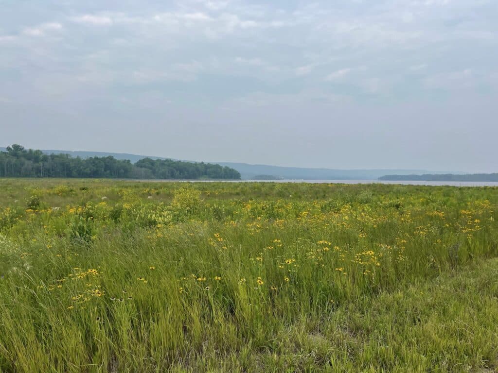
If you’ve read my other trip reports about hiking trails in northeast Minnesota, it’s clear that I love a good challenge. But there’s something to be said about a nice, easy trail where you can enjoy the views, take inventory of the wildflowers, and focus on getting caught up with friends. The Marten Trail is just that.
As we walked, he explained that this area was formerly occupied by U.S. Steel and part of the Superfund National Priorities List. He told me about all the cleanup and dredging that took place before this trail could take shape. While it’s disheartening to think about all that we humans have done—and continue to do—to degrade our priceless natural resources, I find glimmers of hope in places like this. I shared this thought, and then I told him about how, when I think about the doom and gloom, I remember the trumpeter swans. Nearly extinct by the early 20th century, trumpeter swans can be found in abundance throughout Minnesota and especially on our north country lakes.

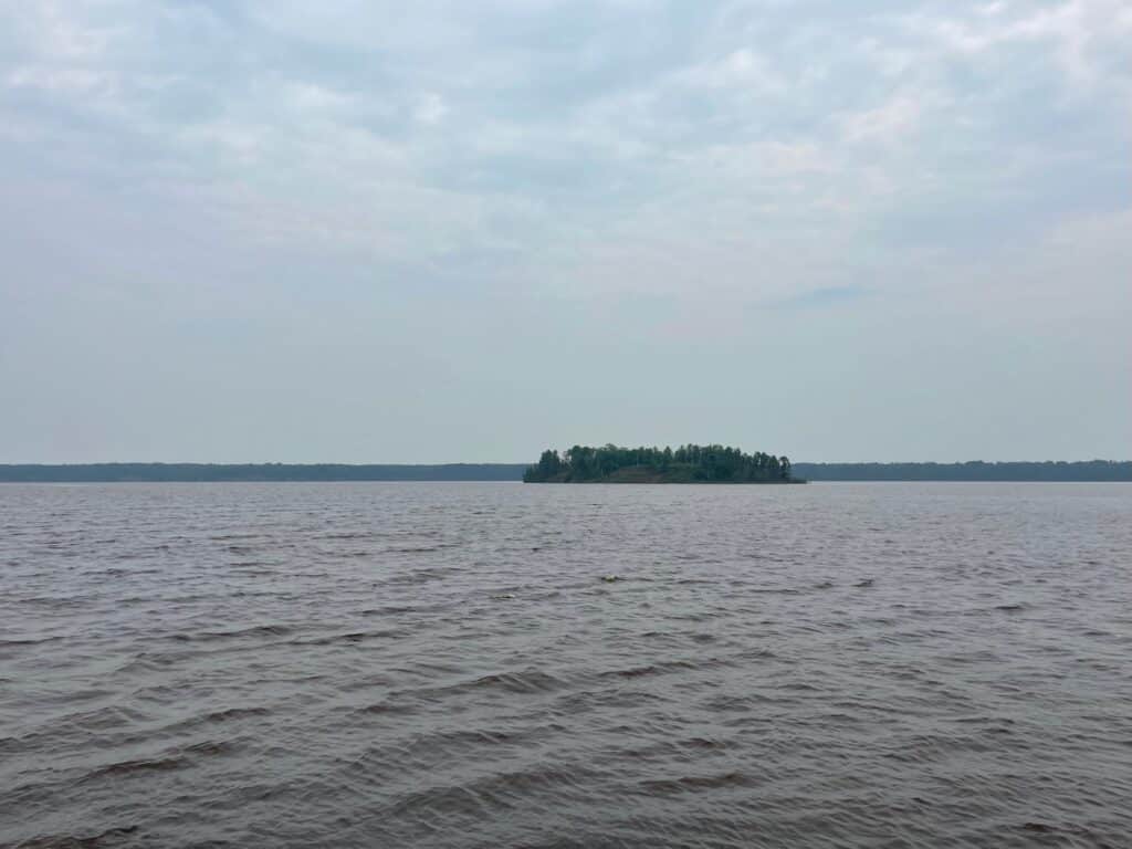
We walked to the southernmost point of the existing trail, marveling at the spectacular wildflowers in all their midsummer blooming perfection. He told me about how he’d been section kayaking the St. Louis River from Lake Superior, and I felt a tinge of envy that he called northeastern Minnesota home. He then led me out to the peninsula and pointed out where you can see the Bong Bridge on a clear day. Although the air was filled with heavy smoke from Canadian wildfires, it was still a beautiful sight.
We wrapped up our hike, finished getting caught up, and I was back on the road. While I’m perfectly content hiking alone, it was a real treat to have a local offer me a guided tour. It made every moment of Sunday traffic worth it. The next time you’re heading through Duluth, consider a walk along Waabizheshikana and think about all the fascinating stories that made their way through this very special watershed.
Planning Your Visit
Getting There: Park at the small three-spot lot at the end of Falcon Street in Morgan Park, Duluth. Note that this location may not appear on all navigation apps. Additional parking is available at Blackmer Park.
Trail Details: This is an easy, accessible trail perfect for enjoying views and wildflowers while having conversations. The trail is still under construction, with completion expected by the end of 2026.
What to Expect: Beautiful wildflowers (especially in midsummer), views of the St. Louis River estuary, and future educational opportunities about the history and freshwater ecosystems.
Best For: Easy walks, nature photography, and those interested in environmental restoration.
Learn More:
- Waabizheshikana Project Overview
- Waabizheshikana Interactive Map
- National Park Service Article – Waabizheshikana: The Marten Trail
- The Stories and Science of the St. Louis River Estuary