

August 7 Update via USDA Forest Service:
Current road closures
As of August 7th, sixteen roads are still closed due to damage from the June 18 storm. Throughout June and into July, the Forest Service issued numerous emergency closure orders for areas affected by the storms across the 3 million-acre wilderness.
- The LaCroix Ranger District reopened FR 203H (Elephant Lake Spur H) and FR 487A (Gold Mine Impoundment Road).
- The Laurentian Ranger District reopened FR 247 (Big Rice Lake Rd), FR 256 (Hulm/Pfeiffer Lake Road), FR 273 (Bates Road), FR 278 (Dewey Lake Rd), and FR 279 (Shannon Lake Road).
- The Kawishiwi Ranger District reopened FR 1027 (Big Lake Boat Access).
- The Tofte Ranger District reopened FR 377 (Tomahawk Rd) and FR 172 (Wanless Rd).
Superior National Forest Storm Damage Update – August 7, 2024 – USFS
July 1 Update via USDA Forest Service:
- Trout Lake Mechanical Portage #1 and #1A (reopened)
June 29 Update via USDA Forest Service:
- Trout Lake Mechanical Portage #1 and #1A
How do I know if an BWCAW Entry Point is open?
All other previously closed BWCAW entry points are open. Call your permit issue location or the Ranger Station closest to your Entry Point with questions. See the Alerts banner on Recreation.gov for the latest updates.
June 24 Update via USDA Forest Service:
- Trout Lake Overnight Motor Entry Point #1
- Trout Lake Day Use Motor Entry Point #A
- Slim Lake Entry Point #6
- Moose River North Entry Point #16
- Island River Entry Point #34
- Isabella Lake Entry Point #35
- Bog Lake Entry Point #67
- Pow Wow Trail Entry Point #86
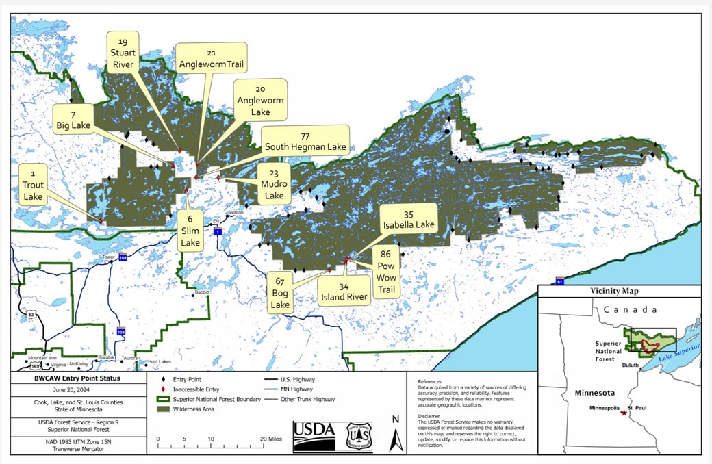
The following BWCAW entry points are now open:
- South Hegman Lake Entry Point #77
- Angleworm Lake Entry Point #20
- Angleworm Trail Entry Point #21
- Stuart River Entry Point #19
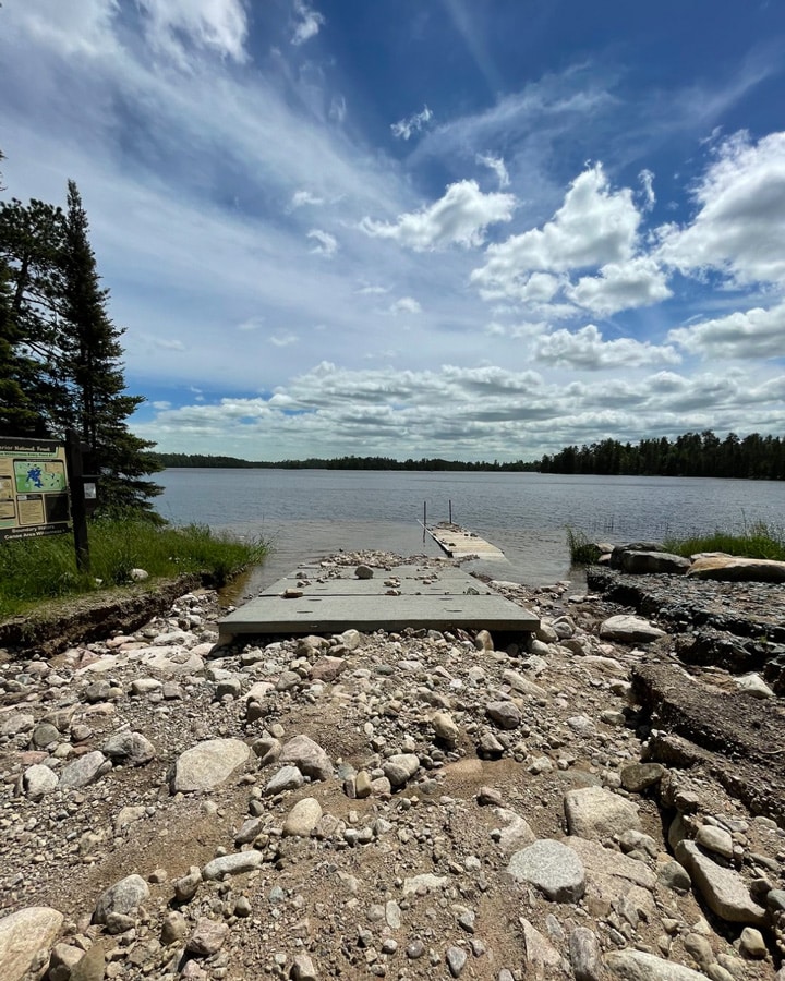
Visitors should use extreme caution on canoe routes throughout the BWCAW and the SNF. River and stream flows are fast-moving with swift water. They continue rising in some locations. Flooding may affect portages or make them more difficult to locate. Stay within your skill levels and ensure your safety and flexibility. If conditions exceed your group’s abilities, you should turn around and leave the area. Finally, please remember to wear your life jacket.
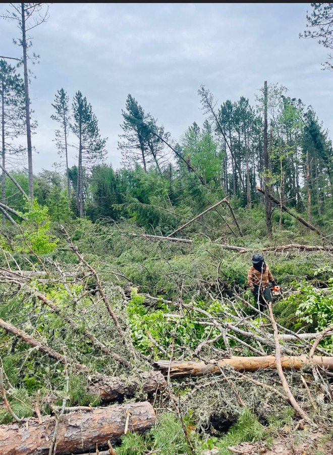
Blowdown areas
Some areas were affected by high winds from the recent storm. Areas of impact include the Gunflint and Tofte districts.
- Border Route Trail Entry Points #81-83. This area has 10–15-acre pockets from Gunflint Lake heading east.
- Areas north of Greenwood Lake, adjacent to the BWCAW, include pockets of blowdown ranging from approximately 10 to 25 acres in size. The blowdowns are scattered and generally not near portages.
- Significant pockets of blowdown are located in the Rose Lake area east towards Mountain Lake.
- The Tofte Ranger District has multiple pockets of 50+ acres of blow down along the Sawbill Trail and Kawishiwi Lake areas. Windy Lake, Clearwater, and Clara Lake areas also have blowdown acres.
- The Temperance River corridor has a lot of pockets of blowdown. Currently, tree fall is not blocking river access or across the trail, but conditions could change.
- The Lost Lake Road area has 10 to 20-acre blown-down patches.
- The Timber-Frear ATV Trail on the Tofte Ranger District has been heavily impacted by the blow down.
____________________________________________________________________________________________________________________________
June 22 Update via USDA Forest Service:
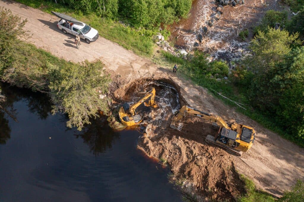
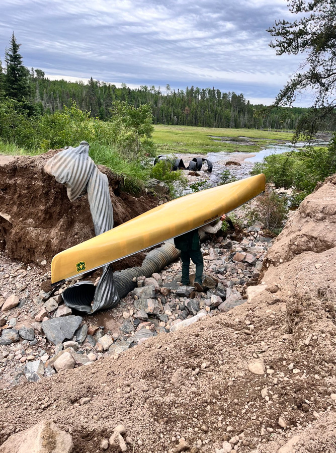
Temporary repairs allowed Boundary Waters Canoe Area Wilderness visitors at the Mudro Lake Entry Point to exit safely with their vehicles and gear. Several forest roads remain closed to public access as they could be washed out again at any time. As water levels start to drop, more permanent repairs can be completed, and safe access restored to affected areas. Temporary repairs are also underway at the Trout Lake Motorized Portage so that visitors can be safely portaged out of the BWCAW to Lake Vermilion. It is expected to remain closed this weekend and conditions reassessed on June 24, 2024.
June 21 Update:
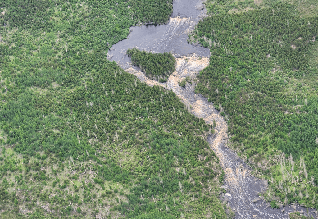
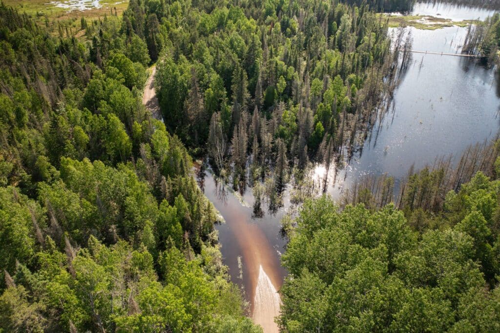
Severe thunderstorms with heavy rainfall caused extensive damage to roads and flooding within the Superior National Forest (SNF), including the Boundary Waters Canoe Area Wilderness (BWCAW). In response, the USFS – Superior National Forest has closed several entry points. As a result, the agency is notifying individuals who reserved BWCA permits through June 22, 2024, directly about the cancellation and refunding them.
The Forest Service is reassessing conditions and access routes daily to determine whether to extend the length of permit cancellations. In addition, local partners are actively working to repair roads and remove fallen trees. Rainfall amounts in the northern counties ranged from 5 to 9 inches, prompting a wilderness advisory to be issued.
Closed BWCA entry points
The USFS has temporarily closed the following BWCAW entry points:
- Entry Point #1: Trout Lake Overnight Motor and Day Use Motor. Note: Overnight paddle permits are still being issued and the canoe portage is open.
- Entry Point #6: Slim Lake
- Entry Point # 7: Big Lake
- Entry Point # 16: Moose River North Entry Point
- Entry Point # 19: Stuart River
- Entry Point # 20: Angleworm Lake
- Entry Point # 21: Angleworm Trail
- Entry Point #23: Mudro Lake
- Entry Point #34: Island River
- Entry Point #35: Isabella Lake
- Entry Point #67: Bog Lake
- Entry Point #77: South Hegman Lake
- Entry Point #86: Pow Wow Trail
Local agencies responding
Ranger districts continue to assess impacts on forest roads. First responders have also been actively assisting. “We deployed teams throughout the day [Wednesday] to check on trapped homeowners and offer evacuation. Many areas have not yet reached their peak, and more rain is expected by the end of the week. Local fire departments and ambulance services are handling numerous calls,” the St. Louis County Rescue reported on social media.
The MNDOT has closed some roads in northern Minnesota. In certain areas, vehicles may need to remain in places inaccessible by road. The USFS, along with local partners, are aware of the situation and are working to ensure the safe evacuation of residents and wilderness visitors. A comprehensive list of affected roads will be shared once it becomes available.
Wilderness travel advisory
Trees are susceptible to falling due to saturated ground. Recent rain events have caused high and fast-moving water throughout the SNF and BWCAW. Consequently, portage landings may be flooded, hard to identify, and be near swift-moving water. When planning travel routes, honestly assess your group’s skills and abilities. If conditions exceed your group’s skills, change your route or exit the wilderness promptly. Always wear a life jacket. Water temperatures are still cold.
Headed further north? Travelers planning trips to Quetico Provincial Park in Canada should contact local ranger stations beforehand. The park has observed high water levels in areas like the Maligne River.
Lastly, continued rain is expected in the upcoming days. For the latest updates on closed entry points, please follow the Superior National Forest at www.fs.usda.gov/superior or X/Twitter @SuperiorNF, on Facebook.
More info:
- Forest Roads and BWCAW Entry Points inaccessible due to washouts and flooding – USFS Superior National Forest
- Superior National Forest June 18 Storm Response – USFS Superior National Forest
- Heavy rain brings flooding to the North Shore, closes trails and roads – MPR News
- Nine-Year-Old Injured on Snipe Lake in BWCA During Severe Thunderstorm – Paddle and Portage

Wilderness guide and outdoorswoman Pam Wright has been exploring wild places since her youth. Remaining curious, she has navigated remote lakes in Canada by canoe, backpacked some of the highest mountains in the Sierra Nevada, and completed a thru-hike of the Superior Hiking Trail. Her professional roles include working as a wilderness guide in northern Minnesota and providing online education for outdoor enthusiasts.